Login
Register


04Y
Hawley Municipal Airport
Official FAA Data Effective 2024-04-18 0901Z
Chart Supplement

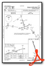
VFR Chart of 04Y
Sectional Charts at SkyVector.com
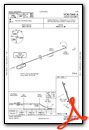
IFR Chart of 04Y
Enroute Charts at SkyVector.com
Location Information for 04Y
Coordinates: N46°53.03' / W96°21.04'Located 02 miles W of Hawley, Minnesota on 79 acres of land. View all Airports in Minnesota.
Surveyed Elevation is 1209 feet MSL.
Operations Data
|
|
Airport Communications
| FARGO APPROACH: | 120.4 377.15 |
|---|---|
| FARGO DEPARTURE: | 120.4 377.15 |
| UNICOM: | 122.800 |
| CTAF: | 122.800 |
| AWOS-3 at JKJ (13.1 W): | 120.0 218-287-5049 |
| ATIS at FAR (19.2 W): | 124.5 |
| ASOS at FAR (19.2 W): | 701-298-3877 |
Nearby Navigation Aids
|
| ||||||||||||||||||||||||||||||||||||||||||||||||||||||


Runway 16/34
| Dimensions: | 3398 x 75 feet / 1036 x 23 meters | |
|---|---|---|
| Surface: | Asphalt in Fair Condition | |
| Weight Limits: | S-12 | |
| Edge Lighting: | Medium Intensity | |
| Runway 16 | Runway 34 | |
| Coordinates: | N46°53.29' / W96°21.17' | N46°52.76' / W96°20.91' |
| Elevation: | 1209.7 | 1199.8 |
| Traffic Pattern: | Left | Left |
| Runway Heading: | 161° True | 341° True |
| Markings: | Non-Precision Instrument in fair condition. | Non-Precision Instrument in fair condition. |
| Glide Slope Indicator | P2L (3.00° Glide Path Angle) | P2L (3.00° Glide Path Angle) |
Services Available
| Fuel: | 100LL (blue) |
|---|---|
| Transient Storage: | Tiedowns |
| Airframe Repair: | NONE |
| Engine Repair: | NONE |
| Bottled Oxygen: | NONE |
| Bulk Oxygen: | NONE |
Ownership Information
| Ownership: | Publicly owned | |
|---|---|---|
| Owner: | CITY OF HAWLEY | |
| CITY HALL, PO BOX 69 | ||
| HAWLEY, MN 56549-0069 | ||
| 218-483-3331 | ||
| Manager: | ERICA POLLEY | |
| PO BOX 69 | ||
| HAWLEY, MN 56549-0069 | ||
| 218-483-3331 | ||
Operational Statistics
| Single Engine Aircraft Based on Field: | 32 | Statistics collected for 12 month period ending 2019-06-30 | |
|---|---|---|---|
| Multi-Engine Aircraft Based on Field: | none | Annual Commercial Operations: | none |
| Jet Aircraft Based on Field: | none | Annual Commuter Operations: | none |
| Helicopters Based on Field: | 1 | Annual Air Taxi Operations: | none |
| Military Aircraft Based on Field: | none | Annual Military Operations: | none |
| Gliders Based on Field: | none | Annual GA Local Operations: | 4600 |
| Ultralights Based on Field: | none | Annual GA Itinerant Operations: | 4000 |
Other Remarks
- ULTRALIGHTS ON & INVOF ARPT.
- FOR CD CTC FARGO APCH AT 701-235-8894.
- 0LL FUEL AVBL H24 VIA CREDIT CARD.
- ACTVT PAPI RWY 16 & 34; MIRL RWY 16/34 - CTAF.
Weather Minimums

Instrument Approach Procedure (IAP) Charts
Nearby Airports with Instrument Procedures
| ID | Name | Heading / Distance | ||
|---|---|---|---|---|
 |
KJKJ | Moorhead Municipal/Florence Klingensmith Field Airport | 258° | 13.2 |
|
KFAR | Hector International Airport | 276° | 19.3 |
|
KDTL | Detroit Lakes/Wething Field Airport | 100° | 19.6 |
|
D00 | Norman County Ada/Twin Valley Airport | 354° | 22.7 |
|
3N8 | Mahnomen County Airport | 037° | 28.5 |
|
K74 | Robert Odegaard Field Airport | 242° | 30.2 |
|
16D | Perham Municipal Airport | 117° | 34.8 |
|
5N8 | Casselton Robert Miller Regional Airport | 267° | 35.3 |
|
KFFM | Fergus Falls Municipal/Einar Mickelson Field Airport | 167° | 36.9 |
|
KBWP | Harry Stern Airport | 195° | 39.8 |
|
D14 | Fertile Municipal Airport | 003° | 40.2 |
|
3H4 | Hillsboro Municipal Airport | 314° | 40.8 |
Airport Images
Do you have a recent image of this airport? Upload it here!


