Login
Register


06N
Randall Airport
Official FAA Data Effective 2024-04-18 0901Z
Chart Supplement

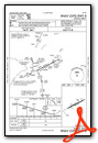
VFR Chart of 06N
Sectional Charts at SkyVector.com
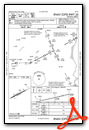
IFR Chart of 06N
Enroute Charts at SkyVector.com
Location Information for 06N
Coordinates: N41°25.91' / W74°23.49'Located 02 miles SE of Middletown, New York on 77 acres of land. View all Airports in New York.
Surveyed Elevation is 522 feet MSL.
Operations Data
|
|
Airport Communications
| NEW YORK APPROACH: | 132.75 363.1 |
|---|---|
| NEW YORK DEPARTURE: | 132.75 363.1 |
| UNICOM: | 122.800 |
| CTAF: | 122.800 |
| ASOS at MGJ (7.4 NE): | 119.275 845-457-1486 |
| ATIS at SWF (13.6 E): | 124.575 |
| ASOS at FWN (17.5 SW): | 118.525 973-875-0859 |
Nearby Navigation Aids
|
| ||||||||||||||||||||||||||||||||||||||||||||||||||||||||||||


Runway 08/26
| Dimensions: | 2810 x 60 feet / 856 x 18 meters | |
|---|---|---|
| Surface: | Asphalt in Fair Condition SW STRENGTH IS 12.5 | |
| Weight Limits: | S-25 | |
| Edge Lighting: | Medium Intensity SEVERAL RWY AND TWY LGTS OTS INDEFLY. | |
| Runway 08 | Runway 26 | |
| Coordinates: | N41°25.81' / W74°23.77' | N41°26.02' / W74°23.22' |
| Elevation: | 503.0 | 520.7 |
| Traffic Pattern: | Left | Left |
| Runway Heading: | 63° True | 243° True |
| Displaced Threshold: | 563 Feet | |
| Markings: | Non-Precision Instrument in poor condition. | Non-Precision Instrument in poor condition. |
| Glide Slope Indicator | P2L (4.00° Glide Path Angle) | P2R (4.00° Glide Path Angle) OTS INDEFLY. |
| Obstacles: | 16 ft Road 200 ft from runway, 72 ft right of center RWY 08 APCH SLOPE 16:1 DUE TO 65 FT TREE 1040 FT FM DTHR. +16FT ROAD, 0-200FT FRM RWY, 72FT RIGHT; +25FT TO +40FT TREES, 0-75FT FRM RWY, 120-140FT RT; +4FT FENCE, 0-200FT FRM RWY, 50 FT RT |
48 ft Trees 344 ft from runway, 104 ft left of center RISING TERRAIN, +0FT TO +17FT HIGH, 0-200FT FRM RWY, 0-250FT RT; +25 FT TREES, 0-200FT FRM RWY, 175-200 FT LT. |
Services Available
| Fuel: | NONE |
|---|---|
| Transient Storage: | Tiedowns |
| Airframe Repair: | NONE |
| Engine Repair: | NONE |
| Bottled Oxygen: | NONE |
| Bulk Oxygen: | NONE |
| Other Services: | GLIDER SERVICE,GLIDER TOWING SERVICES |
Ownership Information
| Ownership: | Privately Owned | |
|---|---|---|
| Owner: | AERODROME DEV CORP | |
| PO BOX 3062, 100 AIRPORT RD | ||
| MIDDLETOWN, NY 10940 | ||
| 845-343-5965 | ||
| Manager: | CHARLES BRODIE | |
| P O BOX 3062, 100 AIRPORT RD | ||
| MIDDLETOWN, NY 10940 | ||
| 845-343-5965 | ||
Operational Statistics
| Single Engine Aircraft Based on Field: | 15 | Statistics collected for 12 month period ending 2021-08-12 | |
|---|---|---|---|
| Multi-Engine Aircraft Based on Field: | none | Annual Commercial Operations: | none |
| Jet Aircraft Based on Field: | none | Annual Commuter Operations: | none |
| Helicopters Based on Field: | none | Annual Air Taxi Operations: | none |
| Military Aircraft Based on Field: | none | Annual Military Operations: | none |
| Gliders Based on Field: | 20 | Annual GA Local Operations: | 17000 |
| Ultralights Based on Field: | none | Annual GA Itinerant Operations: | 5500 |
Other Remarks
- HVY GLIDER & HANG GLIDER ACT ON WKENDS & HOLS.
- ULTRA-LIGHT ON AND INVOF ARPT.
- FOR CD CTC NEW YORK APCH AT 516-683-2448
- RUNWAY MARKINGS VERY BADLY FADED
- ACTVT MIRL RWY 08/26 - CTAF.
Weather Minimums
Instrument Approach Procedure (IAP) Charts
Nearby Airports with Instrument Procedures
| ID | Name | Heading / Distance | ||
|---|---|---|---|---|
 |
KMGJ | Orange County Airport | 050° | 7.5 |
|
N82 | Wurtsboro/Sullivan County Airport | 343° | 10.4 |
|
KSWF | New York Stewart International Airport | 071° | 13.6 |
|
KFWN | Sussex Airport | 217° | 17.4 |
|
N89 | Joseph Y Resnick Airport | 002° | 17.8 |
|
4N1 | Greenwood Lake Airport | 173° | 18.3 |
|
KMSV | Sullivan County International Airport | 311° | 24.3 |
|
KPOU | Hudson Valley Regional Airport | 062° | 25.7 |
|
N07 | Lincoln Park Airport | 173° | 29.2 |
|
12N | Aeroflex/Andover Airport | 211° | 29.8 |
|
44N | Sky Acres Airport | 060° | 33.8 |
|
KCDW | Essex County Airport | 171° | 33.8 |
Airport Images
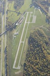
By: chealy


