Login
Register


0B5
Turners Falls Airport
Official FAA Data Effective 2024-04-18 0901Z
Chart Supplement

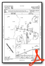
VFR Chart of 0B5
Sectional Charts at SkyVector.com
IFR Chart of 0B5
Enroute Charts at SkyVector.com
Location Information for 0B5
Coordinates: N42°35.50' / W72°31.38'Located 03 miles N of Montague, Massachusetts on 333 acres of land. View all Airports in Massachusetts.
Surveyed Elevation is 358 feet MSL.
Operations Data
|
|
Airport Communications
| UNICOM: | 123.000 |
|---|---|
| CTAF: | 123.000 |
| ASOS at ORE (10.5 E): | 135.675 978-544-6774 |
| AWOS-3PT at EEN (21.5 NE): | 119.025 603-358-6424 |
| ATIS at CEF (23.9 S): | 127.525 |
- APCH/DEP SVC PRVDD BY BOSTON ARTCC ON FREQS 123.75/338.2 (GARDNER RCAG).
Nearby Navigation Aids
|
| ||||||||||||||||||||||||||||||||||||||||||||||||||||||||||||


Runway 16/34
| Dimensions: | 3200 x 75 feet / 975 x 23 meters | |
|---|---|---|
| Surface: | Asphalt in Excellent Condition | |
| Weight Limits: | S-30 | |
| Edge Lighting: | Medium Intensity | |
| Runway 16 | Runway 34 | |
| Coordinates: | N42°35.71' / W72°31.60' | N42°35.29' / W72°31.16' |
| Elevation: | 352.7 | 358.7 |
| Traffic Pattern: | Left | Left |
| Runway Heading: | 143° True | 323° True |
| Displaced Threshold: | 550 Feet | |
| Markings: | Basic in good condition. | Basic in good condition. |
| Glide Slope Indicator | P4L (3.00° Glide Path Angle) | |
| REIL: | Yes | |
| Obstacles: | 20 ft Trees 600 ft from runway, 130 ft left of center | 30 ft Trees 800 ft from runway, 150 ft right of center |
Services Available
| Fuel: | 100LL (blue), Jet A-1 |
|---|---|
| Transient Storage: | Hangars,Tiedowns |
| Airframe Repair: | MAJOR |
| Engine Repair: | MAJOR |
| Bottled Oxygen: | NONE |
| Bulk Oxygen: | NONE |
| Other Services: | AIR FREIGHT SERVICES,AVIONICS,PILOT INSTRUCTION,AIRCRAFT RENTAL |
Ownership Information
| Ownership: | Publicly owned | |
|---|---|---|
| Owner: | TOWN OF MONTAGUE | |
| 1 AVENUE A | ||
| TURNERS FALLS, MA 01376 | ||
| 413-863-0044 | ||
| Manager: | BRYAN CAMDEN | |
| C/O TOWN OF MONTAGUE, 1 AVENUE A | ||
| TURNERS FALLS, MA 01376 | ||
| 413-863-0044 | AMGR CTC 24 HRS CELL 978-305-2452. | |
Operational Statistics
| Single Engine Aircraft Based on Field: | 32 | Statistics collected for 12 month period ending 2022-03-14 | |
|---|---|---|---|
| Multi-Engine Aircraft Based on Field: | 1 | Annual Commercial Operations: | none |
| Jet Aircraft Based on Field: | none | Annual Commuter Operations: | none |
| Helicopters Based on Field: | 2 | Annual Air Taxi Operations: | 95 |
| Military Aircraft Based on Field: | none | Annual Military Operations: | 150 |
| Gliders Based on Field: | none | Annual GA Local Operations: | 15000 |
| Ultralights Based on Field: | none | Annual GA Itinerant Operations: | 6000 |
Other Remarks
- RWY 16 IS CALM WIND RWY.
- WILDLIFE & BIRDS INVOF ARPT.
- FOR CD CTC BOSTON ARTCC AT 603-879-6859.
- COLD TEMPERATURE AIRPORT. ALTITUDE CORRECTION REQUIRED AT OR BELOW -26C.
- FUEL CART CTC AMGR.
- ACTVT REIL RWY 16; MIRL RWY 16/34 - CTAF.
Weather Minimums
Instrument Approach Procedure (IAP) Charts
Nearby Airports with Instrument Procedures
| ID | Name | Heading / Distance | ||
|---|---|---|---|---|
 |
KORE | Orange Municipal Airport | 097° | 10.5 |
|
7B2 | Northampton Airport | 193° | 16.3 |
|
KEEN | Dillant/Hopkins Airport | 031° | 21.5 |
|
KGDM | Gardner Municipal Airport | 096° | 22.6 |
|
KCEF | Westover Arb/Metro Airport | 181° | 23.9 |
|
KAFN | Jaffrey Airfield Silver Ranch Airport | 060° | 26.3 |
|
KBAF | Westfield-Barnes Regional Airport | 198° | 27.4 |
|
KAQW | Harriman-and-West Airport | 282° | 29.4 |
|
KFIT | Fitchburg Municipal Airport | 093° | 33.9 |
|
KORH | Worcester Regional Airport | 123° | 34.7 |
|
KPSF | Pittsfield Municipal Airport | 254° | 35.5 |
|
3B0 | Southbridge Municipal Airport | 143° | 36.5 |
Airport Images
Do you have a recent image of this airport? Upload it here!


