Login
Register


12N
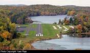
Aeroflex/Andover Airport
Official FAA Data Effective 2024-04-18 0901Z
Chart Supplement

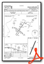
VFR Chart of 12N
Sectional Charts at SkyVector.com
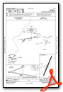
IFR Chart of 12N
Enroute Charts at SkyVector.com
Location Information for 12N
Coordinates: N41°0.52' / W74°44.28'Located 03 miles N of Andover, New Jersey on 12 acres of land. View all Airports in New Jersey.
Estimated Elevation is 582 feet MSL.
Operations Data
|
|
Airport Communications
| ASOS: | Tel. 917-786-7221 |
|---|---|
| NEW YORK APPROACH: | 127.6 379.9 |
| NEW YORK DEPARTURE: | 127.6 379.9 |
| CTAF: | 122.800 |
| UNICOM: | 122.800 |
| ASOS at FWN (12.5 NE): | 118.525 973-875-0859 |
| ATIS at MMU (19.3 SE): | 124.25 |
| AWOS-3 at MMU (19.4 SE): | 973-290-0135 |
Nearby Navigation Aids
|
| ||||||||||||||||||||||||||||||||||||||||||||||||||||||||||||


Runway 03/21
| Dimensions: | 1981 x 50 feet / 604 x 15 meters | |
|---|---|---|
| Surface: | Asphalt in Good Condition | |
| Edge Lighting: | Medium Intensity | |
| Runway 03 | Runway 21 | |
| Coordinates: | N41°0.37' / W74°44.36' | N41°0.67' / W74°44.20' |
| Elevation: | 582.4 | 582.5 |
| Traffic Pattern: | Right | Left |
| Runway Heading: | 21° True | 201° True |
| Markings: | Non-Precision Instrument in good condition. | Basic in good condition. |
| Obstacles: | 108 ft Trees 504 ft from runway, 256 ft left of center RWY 03 80 FT TREE AT RWY END 167 FT LEFT OF CNTRLN. |
64 ft Tree 580 ft from runway, 150 ft right of center RY 21 15 FT ROAD AT THLD. |
Services Available
| Fuel: | 100LL (blue) |
|---|---|
| Transient Storage: | Tiedowns |
| Airframe Repair: | MAJOR |
| Engine Repair: | MAJOR |
| Bottled Oxygen: | NONE |
| Bulk Oxygen: | NONE |
| Other Services: | PILOT INSTRUCTION |
Ownership Information
| Ownership: | Publicly owned | |
|---|---|---|
| Owner: | NJ ST FOREST FIRE SVC | |
| PO BOX 404 | ||
| TRENTON, NJ 08625 | ||
| 609-292-2977 | ||
| Manager: | JOHN T FLYNTZ | |
| AEROFLEX-ANDOVER ARPT, P.O. BOX 709 | ||
| ANDOVER, NJ 07821 | ||
| 973-786-5100 | ||
Operational Statistics
| Single Engine Aircraft Based on Field: | 35 | Statistics collected for 12 month period ending 2022-12-31 | |
|---|---|---|---|
| Multi-Engine Aircraft Based on Field: | 1 | Annual Commercial Operations: | none |
| Jet Aircraft Based on Field: | none | Annual Commuter Operations: | none |
| Helicopters Based on Field: | 1 | Annual Air Taxi Operations: | none |
| Military Aircraft Based on Field: | none | Annual Military Operations: | none |
| Gliders Based on Field: | none | Annual GA Local Operations: | 18750 |
| Ultralights Based on Field: | none | Annual GA Itinerant Operations: | 13800 |
Other Remarks
- THIS AIRPORT HAS BEEN SURVEYED BY THE NATIONAL GEODETIC SURVEY.
- AVOID OVERFLYING LAKE LENAPE WHILE ON DOWNWIND.
- FOR CD CTC NEW YORK APCH AT 800-645-3206.
- DEER & BIRDS ON & INVOF ARPT.
- DIRT SVC ROAD TO TRML AREA IN FRONT OF RWY 03 THLD.
- PARALLEL TURF RWY RESTRICTED USE ONLY.
- ARPT RESTRICTED TO APCH CATAGORY A ACFT ONLY.
- NO TGL.
- RY 03/21 LAKES AT BOTH APCH ENDS.
- NOISE ABATEMENT PROCEDURES IN EFFECT. CTC AMGR 973-786-5100.
- PPR REQUIRED FOR NIGHT TRANSIENTS CTC AMGR 973-786-5100.
- ACTVT MIRL RWY 03/21 - CTAF.
Weather Minimums
Instrument Approach Procedure (IAP) Charts
Nearby Airports with Instrument Procedures
| ID | Name | Heading / Distance | ||
|---|---|---|---|---|
 |
1N7 | Blairstown Airport | 259° | 12.0 |
|
KFWN | Sussex Airport | 024° | 12.6 |
|
4N1 | Greenwood Lake Airport | 067° | 19.2 |
|
KMMU | Morristown Municipal Airport | 130° | 19.3 |
|
N07 | Lincoln Park Airport | 100° | 19.6 |
|
KCDW | Essex County Airport | 110° | 22.3 |
|
KSMQ | Somerset Airport | 172° | 23.2 |
|
N51 | Solberg/Hunterdon Airport | 179° | 25.5 |
|
N43 | Braden Airpark Airport | 235° | 28.0 |
|
N85 | Alexandria Airport | 207° | 28.3 |
|
N40 | Sky Manor Airport | 202° | 28.7 |
|
47N | Central Jersey Regional Airport | 167° | 29.7 |
Airport Images

By: davecarr
By: davecarr


