Login
Register


15J
Cook County Airport
Official FAA Data Effective 2024-04-18 0901Z
Chart Supplement

VFR Chart of 15J
Sectional Charts at SkyVector.com
IFR Chart of 15J
Enroute Charts at SkyVector.com
Location Information for 15J
Coordinates: N31°8.21' / W83°27.25'Located 01 miles W of Adel, Georgia on 368 acres of land. View all Airports in Georgia.
Surveyed Elevation is 235 feet MSL.
Operations Data
|
|
Airport Communications
| VALDOSTA APPROACH: | 126.6 ;EAST OF VAD 360-VAD 180 132.375 ;WEST OF VAD R-360 RADIAL 285.6 ;EAST OF VAD 360-VAD 180 |
|---|---|
| VALDOSTA DEPARTURE: | 126.6 ;EAST OF VAD 360-VAD 180 132.375 ;WEST OF VAD R-360 RADIAL 285.6 ;EAST OF VAD 360-VAD 180 |
| IC: | 126.6 ;EAST OF VAD 360-VAD 180 285.6 ;EAST OF VAD 360-VAD 180 |
| UNICOM: | 122.800 |
| CTAF: | 122.800 |
| ATIS at VAD (16.8 SE): | 273.5 |
| AWOS-3PT at TMA (17.6 N): | 118.525 229-386-8937 |
| AWOS-3PT at MGR (18.2 W): | 118.925 229-890-5320 |
- APCH/DEP SVC PRVDD BY JACKSONVILLE ARTCC ON FREQS 133.7/323.3(VALDOSTA RCAG) WHEN VALDOSTA APCH CTL CLSD.
Nearby Navigation Aids
|
| ||||||||||||||||||||||||||||||||||||||||||||||||||||||||||||


Runway 05/23
| Dimensions: | 5501 x 100 feet / 1677 x 30 meters | |
|---|---|---|
| Surface: | Asphalt in Good Condition | |
| Weight Limits: | S-30, D-30 | |
| Edge Lighting: | Medium Intensity | |
| Runway 05 | Runway 23 | |
| Coordinates: | N31°7.79' / W83°27.72' | N31°8.40' / W83°26.95' |
| Elevation: | 232.9 | 234.7 |
| Traffic Pattern: | Left | Left |
| Runway Heading: | 47° True | 227° True |
| Displaced Threshold: | 500 Feet | |
| Declared Distances: | TORA:5501 TODA:5501 ASDA:5501 LDA:5000 | TORA:5501 TODA:5501 ASDA:5501 LDA:5501 |
| Markings: | Non-Precision Instrument in good condition. | Non-Precision Instrument in good condition. |
| Glide Slope Indicator | P2L (3.00° Glide Path Angle) | P2L (3.00° Glide Path Angle) |
| Obstacles: | 12 ft Other 224 ft from runway PLOWED FLD 224 FT FROM EOR. 12 FT FARM EQPT POSS. |
15 ft Road 350 ft from runway, 262 ft right of center |
Runway 15/33
| Dimensions: | 3999 x 100 feet / 1219 x 30 meters | |
|---|---|---|
| Surface: | Asphalt in Good Condition | |
| Weight Limits: | S-30, D-30 | |
| Runway 15 | Runway 33 | |
| Coordinates: | N31°8.63' / W83°27.36' | N31°8.09' / W83°26.92' |
| Elevation: | 234.7 | 234.5 |
| Traffic Pattern: | Left | Left |
| Runway Heading: | 145° True | 325° True |
| Displaced Threshold: | 599 Feet | 349 Feet |
| Declared Distances: | TORA:3999 TODA:3999 ASDA:3859 LDA:3259 | TORA:3999 TODA:3999 ASDA:3999 LDA:3650 |
| Markings: | Basic in good condition. | Basic in good condition. |
| Obstacles: | 15 ft Road 400 ft from runway, 140 ft right of center RWY 15 APCH RATIO 20:1 TO DSPLCD THR. |
15 ft Road 260 ft from runway RWY 33 APCH RATIO 12:1 TO DSPLCD THR. |
Services Available
| Fuel: | 100LL (blue), Jet A+ |
|---|---|
| Transient Storage: | Tiedowns |
| Airframe Repair: | MAJOR |
| Engine Repair: | MAJOR |
| Bottled Oxygen: | NONE |
| Bulk Oxygen: | NONE |
| Other Services: | PILOT INSTRUCTION,AIRCRAFT RENTAL |
Ownership Information
| Ownership: | Publicly owned | |
|---|---|---|
| Owner: | COOK COUNTY | |
| 1200 SO. HUTCHISON | ||
| ADEL, GA 31620 | ||
| 229-896-2266 | ||
| Manager: | JERRY CONNELL | |
| 160 AIRPORT RD. | ||
| ADEL, GA 31620 | ||
| (229) 507-1340 | ||
Operational Statistics
| Single Engine Aircraft Based on Field: | 28 | Statistics collected for 12 month period ending 2022-12-01 | |
|---|---|---|---|
| Multi-Engine Aircraft Based on Field: | 1 | Annual Commercial Operations: | none |
| Jet Aircraft Based on Field: | 2 | Annual Commuter Operations: | none |
| Helicopters Based on Field: | none | Annual Air Taxi Operations: | none |
| Military Aircraft Based on Field: | none | Annual Military Operations: | 3600 |
| Gliders Based on Field: | none | Annual GA Local Operations: | 6120 |
| Ultralights Based on Field: | none | Annual GA Itinerant Operations: | 4080 |
Other Remarks
- FOR CD CTC VALDOSTA APCH AT 229-257-2207, WHEN APCH CLSD CTC JACKSONVILLE ARTCC AT 904-845-1592.
- UNICOM IS UNMON.
- ACTVT PAPI RWY 05 & 23; MIRL RWY 05/23 - CTAF.
Weather Minimums

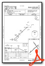
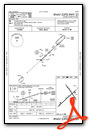
Instrument Approach Procedure (IAP) Charts
Nearby Airports with Instrument Procedures
| ID | Name | Heading / Distance | ||
|---|---|---|---|---|
 |
4J2 | Berrien County Airport | 068° | 12.6 |
|
KVAD | Moody AFB Airport | 126° | 16.8 |
|
KTMA | Henry Tift Myers Airport | 354° | 17.6 |
|
KMGR | Moultrie Municipal Airport | 260° | 18.2 |
|
4J5 | Quitman Brooks County Airport | 199° | 21.0 |
|
KVLD | Valdosta Regional Airport | 156° | 23.2 |
|
KTVI | Thomasville Regional Airport | 237° | 26.1 |
|
KFZG | Fitzgerald Municipal Airport | 015° | 34.1 |
|
75J | Turner County Airport | 344° | 34.2 |
|
KHOE | Homerville Airport | 097° | 35.3 |
|
KDQH | Douglas Municipal Airport | 056° | 36.7 |
|
70J | Cairo-Grady County Airport | 247° | 39.1 |
Airport Images
Do you have a recent image of this airport? Upload it here!


