Login
Register


1A9
Prattville/Grouby Field Airport
Official FAA Data Effective 2024-04-18 0901Z
Chart Supplement

VFR Chart of 1A9
Sectional Charts at SkyVector.com
IFR Chart of 1A9
Enroute Charts at SkyVector.com
Location Information for 1A9
Coordinates: N32°26.32' / W86°30.76'Located 03 miles SW of Prattville, Alabama on 82 acres of land. View all Airports in Alabama.
Surveyed Elevation is 224 feet MSL.
Operations Data
|
|
Airport Communications
| AWOS-3P: | 118.025 Tel. 334-358-0919 |
|---|---|
| MONTGOMERY APPROACH: | 121.2 269.05 |
| MONTGOMERY DEPARTURE: | 121.2 269.05 |
| CTAF: | 122.800 |
| UNICOM: | 122.800 |
| ATIS at MXF (8.2 SE): | 269.9 |
| ASOS at MGM (10.2 SE): | 334-288-0445 |
| ATIS at MGM (10.2 SE): | 120.675 |
- APCH/DEP SVC PRVDD BY ATLANTA ARTCC ON FREQS 120.55/270.25 (MONTGOMERY RCAG) WHEN APCH CTL CLSD.
Nearby Navigation Aids
|
| ||||||||||||||||||||||||||||||||||||||||||||||||||||||||||||


Runway 09/27
| Dimensions: | 5400 x 100 feet / 1646 x 30 meters | |
|---|---|---|
| Surface: | Asphalt in Excellent Condition | |
| Weight Limits: | S-30 | |
| Edge Lighting: | Medium Intensity | |
| Runway 09 | Runway 27 | |
| Coordinates: | N32°26.32' / W86°31.29' | N32°26.33' / W86°30.24' |
| Elevation: | 224.8 | 198.0 |
| Traffic Pattern: | Left | Left |
| Runway Heading: | 89° True | 269° True |
| Markings: | Non-Precision Instrument in good condition. | Non-Precision Instrument in good condition. |
| Glide Slope Indicator | P4L (4.00° Glide Path Angle) OTS INDEFLY. | P4L (3.00° Glide Path Angle) |
| REIL: | Yes | Yes |
| Obstacles: | 114 ft Trees 1397 ft from runway, 300 ft right of center | 12 ft Brush 233 ft from runway, 150 ft right of center |
Services Available
| Fuel: | 100LL (blue), Jet A+ |
|---|---|
| Transient Storage: | Tiedowns |
| Airframe Repair: | NONE |
| Engine Repair: | NONE |
| Bottled Oxygen: | NONE |
| Bulk Oxygen: | NONE |
| Other Services: | PILOT INSTRUCTION,AIRCRAFT RENTAL |
Ownership Information
| Ownership: | Publicly owned | |
|---|---|---|
| Owner: | PRATTVILLE ARPT AUTH. | |
| 1450 AVIATION WAY | ||
| PRATTVILLE, AL 36067 | ||
| 334-361-0060 | ||
| Manager: | PAUL GARDNER | |
| 1450 AVIATION WAY | ||
| PRATTVILLE, AL 36067 | ||
| 334-361-0060 | AFT HRS PHONE 334-730-3458 | |
Operational Statistics
| Single Engine Aircraft Based on Field: | 29 | Statistics collected for 12 month period ending 2019-06-28 | |
|---|---|---|---|
| Multi-Engine Aircraft Based on Field: | 5 | Annual Commercial Operations: | none |
| Jet Aircraft Based on Field: | none | Annual Commuter Operations: | none |
| Helicopters Based on Field: | none | Annual Air Taxi Operations: | 113 |
| Military Aircraft Based on Field: | none | Annual Military Operations: | 163 |
| Gliders Based on Field: | none | Annual GA Local Operations: | 6327 |
| Ultralights Based on Field: | none | Annual GA Itinerant Operations: | 15193 |
Other Remarks
- GCO AVBL ON FREQ 121.725.
- FOR CD IF UNA VIA GCO CTC ATLANTA ARTCC AT 770-210-7692.
- FBO PHONE 334-361-0060
- 0LL 100LL FUEL 24 HR CREDIT CARD SVC AVBL.
- JET A+ FUEL 24 HR CREDIT CARD SVC AVBL
- ACTVT REIL 9 & 27; MIRL RWY 09/27- CTAF.
Weather Minimums

Instrument Approach Procedure (IAP) Charts
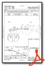
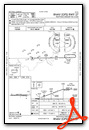
Nearby Airports with Instrument Procedures
| ID | Name | Heading / Distance | ||
|---|---|---|---|---|
 |
KMXF | Maxwell AFB Airport | 114° | 8.2 |
|
KMGM | Montgomery Regional (Dannelly Field) Airport | 143° | 10.2 |
|
08A | Wetumpka Municipal Airport | 060° | 10.6 |
|
KSEM | Craig Field Airport | 256° | 24.8 |
|
02A | Chilton County Airport | 348° | 25.2 |
|
KPRN | Mac Crenshaw Memorial Airport | 188° | 35.9 |
|
KALX | Thomas C Russell Field Airport | 044° | 39.8 |
|
0A8 | Bibb County Airport | 315° | 41.8 |
|
06A | Moton Field Municipal Airport | 088° | 42.3 |
|
KTOI | Troy Municipal At N Kenneth Campbell Field Airport | 143° | 43.0 |
|
A08 | Vaiden Field Airport | 275° | 44.5 |
|
KSCD | Merkel Field Sylacauga Municipal Airport | 013° | 45.1 |
Airport Images

By: rvnavy


