Login
Register


2S8
Wilbur Airport
Official FAA Data Effective 2024-04-18 0901Z
Chart Supplement

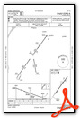
VFR Chart of 2S8
Sectional Charts at SkyVector.com
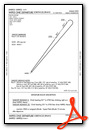
IFR Chart of 2S8
Enroute Charts at SkyVector.com
Location Information for 2S8
Coordinates: N47°45.20' / W118°44.64'Located 02 miles SW of Wilbur, Washington on 107 acres of land. View all Airports in Washington.
Surveyed Elevation is 2183 feet MSL.
Operations Data
|
|
Airport Communications
| AWOS-2: | 124.175 Tel. 509-647-0337 |
|---|---|
| GRANT COUNTY APPROACH: | 126.4 379.95 |
| GRANT COUNTY DEPARTURE: | 126.4 379.95 |
| IC: | 126.4 379.95 |
| CTAF: | 122.900 |
| AWOS-3PT at 3W7 (16.8 NW): | 128.325 509-631-8955 |
| ASOS at MWH (40.2 SW): | 119.05 509-762-5082 |
| ATIS at MWH (40.2 SW): | 119.05 |
- APCH/DEP CTL SVC PRVDD BY SEATTLE ARTCC (ZSE) ON FREQS 126.1/291.6 (MARLIN RCAG) WHEN GRANT COUNTY APCH CTL (MWH) CLSD.
Nearby Navigation Aids
|
| ||||||||||||||||||||||||||||||||||||||||||||||||


Runway 02/20
| Dimensions: | 3851 x 60 feet / 1174 x 18 meters | |
|---|---|---|
| Surface: | Asphalt in Excellent Condition | |
| Weight Limits: | S-15 | |
| Edge Lighting: | Medium Intensity | |
| Runway 02 | Runway 20 | |
| Coordinates: | N47°44.95' / W118°44.91' | N47°45.46' / W118°44.36' |
| Elevation: | 2165.4 | 2183.1 |
| Traffic Pattern: | Left | Left |
| Runway Heading: | 36° True | 216° True |
| Markings: | Non-Precision Instrument in good condition. | Basic in good condition. |
| Glide Slope Indicator | P2L (3.00° Glide Path Angle) | |
| REIL: | Yes | |
Services Available
| Fuel: | 100LL (blue), Jet-A |
|---|---|
| Transient Storage: | Tiedowns PILOTS BRING OWN ROPES. |
| Airframe Repair: | MINOR |
| Engine Repair: | MINOR |
| Bottled Oxygen: | NONE |
| Bulk Oxygen: | NONE |
| Other Services: | CROP DUSTING SERVICES |
Ownership Information
| Ownership: | Publicly owned | |
|---|---|---|
| Owner: | TOWN OF WILBUR | |
| PO BOX 214 | ||
| WILBUR, WA 99185 | ||
| 509-647-5821 | ||
| Manager: | KEVIN LEYVA | |
| PO BOX 87 | ||
| WILBUR, WA 99185 | ||
| 509-641-2079 | ||
Operational Statistics
| Single Engine Aircraft Based on Field: | 21 | Statistics collected for 12 month period ending 2021-12-31 | |
|---|---|---|---|
| Multi-Engine Aircraft Based on Field: | none | Annual Commercial Operations: | none |
| Jet Aircraft Based on Field: | none | Annual Commuter Operations: | none |
| Helicopters Based on Field: | none | Annual Air Taxi Operations: | none |
| Military Aircraft Based on Field: | none | Annual Military Operations: | none |
| Gliders Based on Field: | none | Annual GA Local Operations: | 2200 |
| Ultralights Based on Field: | none | Annual GA Itinerant Operations: | 3500 |
Other Remarks
- CHECK NOTAMS FOR FIRE FIGHTING OPERATIONS IN SUMMER MONTHS.
- WILDLIFE INVOF RUNWAY.
- FOR CD CTC SEATTLE ARTCC AT 253-351-3694.
- ACTVT MIRL RY 02/20 - CTAF. PAPI RY 20 OPER CONTINUOUSLY.
Weather Minimums
Instrument Approach Procedure (IAP) Charts
Departure Procedure Obstacles (DPO) Charts
Nearby Airports with Instrument Procedures
| ID | Name | Heading / Distance | ||
|---|---|---|---|---|
 |
KMWH | Grant County International Airport | 215° | 40.2 |
|
KEPH | Ephrata Municipal Airport | 229° | 41.3 |
|
KSKA | Fairchild AFB Airport | 100° | 44.9 |
|
KGEG | Spokane International Airport | 098° | 49.7 |
|
KOMK | Omak Airport | 324° | 52.8 |
|
KDEW | Deer Park Airport | 075° | 54.7 |
|
KSFF | Felts Field Airport | 093° | 57.7 |
|
KEAT | Pangborn Memorial Airport | 250° | 63.1 |
|
KCOE | Coeur D'Alene/Pappy Boyington Field Airport | 088° | 77.9 |
|
KELN | Bowers Field Airport | 239° | 84.6 |
|
KRLD | Richland Airport | 195° | 89.9 |
|
KPUW | Pullman/Moscow Regional Airport | 131° | 90.2 |
Airport Images
Do you have a recent image of this airport? Upload it here!


