Login
Register


4A4
Polk County/Cornelius Moore Field Airport
Official FAA Data Effective 2024-04-18 0901Z
Chart Supplement

VFR Chart of 4A4
Sectional Charts at SkyVector.com
IFR Chart of 4A4
Enroute Charts at SkyVector.com
Location Information for 4A4
Coordinates: N34°1.11' / W85°8.69'Located 05 miles E of Cedartown, Georgia on 121 acres of land. View all Airports in Georgia.
Surveyed Elevation is 973 feet MSL.
Operations Data
|
|
Airport Communications
| UNICOM: | 122.800 |
|---|---|
| CTAF: | 122.800 |
| AWOS-3 at PUJ (11.3 SE): | 126.225 770-445-3870 |
| AWOS-3PT at VPC (15.8 E): | 120.525 770-607-7782 |
| ASOS at RMG (20.0 N): | 119.925 706-235-3335 |
- APCH/DEP SVC PRVDD BY ATLANTA ARTCC ON FREQS 124.5/270.325 (GADSDEN RCAG).
Nearby Navigation Aids
|
| ||||||||||||||||||||||||||||||||||||||||||||||||||||||||||||


Runway 10/28
| Dimensions: | 5060 x 75 feet / 1542 x 23 meters | |
|---|---|---|
| Surface: | Asphalt in Fair Condition | |
| Weight Limits: | S-20 | |
| Edge Lighting: | Medium Intensity | |
| Runway 10 | Runway 28 | |
| Coordinates: | N34°1.16' / W85°9.18' | N34°1.06' / W85°8.19' |
| Elevation: | 971.2 | 938.1 |
| Traffic Pattern: | Left | Left |
| Runway Heading: | 97° True | 277° True |
| Markings: | Non-Precision Instrument in good condition. | Non-Precision Instrument in good condition. |
| Glide Slope Indicator | P2L (3.00° Glide Path Angle) | P2L (3.00° Glide Path Angle) |
| Obstacles: | 26 ft Trees 356 ft from runway, 227 ft right of center | |
Services Available
| Fuel: | 100LL (blue), Jet-A |
|---|---|
| Transient Storage: | Tiedowns |
| Airframe Repair: | NONE |
| Engine Repair: | NONE |
| Bottled Oxygen: | NONE |
| Bulk Oxygen: | NONE |
| Other Services: | PARACHUTE JUMP ACTIVITY |
Ownership Information
| Ownership: | Publicly owned | |
|---|---|---|
| Owner: | POLK COUNTY | |
| 216 MAIN ST | ||
| CEDARTOWN, GA 30125 | ||
| 770-749-2100 | ||
| Manager: | CHUCK BEAVERS | |
| 500 AIRPORT ROAD, 144 WEST AVE | ||
| CEDARTOWN, GA 30125 | ||
| 770-684-7136 | FBO 770-684-7136. | |
Operational Statistics
| Single Engine Aircraft Based on Field: | 45 | Statistics collected for 12 month period ending 2022-12-31 | |
|---|---|---|---|
| Multi-Engine Aircraft Based on Field: | 4 | Annual Commercial Operations: | none |
| Jet Aircraft Based on Field: | none | Annual Commuter Operations: | none |
| Helicopters Based on Field: | 8 | Annual Air Taxi Operations: | none |
| Military Aircraft Based on Field: | none | Annual Military Operations: | 50 |
| Gliders Based on Field: | none | Annual GA Local Operations: | 11000 |
| Ultralights Based on Field: | 1 | Annual GA Itinerant Operations: | 4000 |
Other Remarks
- DEER & BIRDS ON & INVOF OF ARPT.
- EXTENSIVE PARACHUTE ACTIVITY ON WEEKENDS - AVOID OVERFLIGHTS OF ARPT.
- FOR CD CTC ATLANTA ARTCC AT 770-210-7692.
- MNT CTAF FREQ AND FRQLY BCST LCTN AND INTNS FOR RWY USE DUE TO NO LINE OF SIGHT BTN RWY ENDS.
- RWY 10 IS THE PREFERRED DEP RWY DURG CALM WINDS.
- NO LINE OF SIGHT BTN RWY ENDS.
- ACTVT PAPI RWY 10 & 28; MIRL RWY 10/28 - CTAF.
Weather Minimums

Instrument Approach Procedure (IAP) Charts
Nearby Airports with Instrument Procedures
| ID | Name | Heading / Distance | ||
|---|---|---|---|---|
 |
KPUJ | Paulding Northwest Atlanta Airport | 121° | 12.0 |
|
KVPC | Cartersville Airport | 066° | 16.0 |
|
KRMG | Richard B Russell Regional - J H Towers Field Airport | 358° | 19.9 |
|
KCTJ | West Georgia Regional - O V Gray Field Airport | 180° | 23.2 |
|
KPYP | Centre-Piedmont-Cherokee County Regional Airport | 280° | 23.6 |
|
KRYY | Cobb County International/Mccollum Field Airport | 090° | 27.3 |
|
KCZL | Tom B David Field Airport | 021° | 28.1 |
|
KMGE | Dobbins Arb Airport | 101° | 32.1 |
|
KFTY | Fulton County Exec/Charlie Brown Field Airport | 114° | 34.3 |
|
4A9 | Isbell Field Airport | 313° | 39.6 |
|
KCNI | Cherokee County Regional Airport | 063° | 40.0 |
|
9A5 | Barwick Lafayette Airport | 349° | 40.8 |
Airport Images
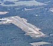
By: Big Orange Bird


