Login
Register


4A5
Searcy County Airport
Official FAA Data Effective 2024-04-18 0901Z
Chart Supplement

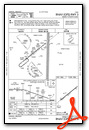
VFR Chart of 4A5
Sectional Charts at SkyVector.com
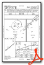
IFR Chart of 4A5
Enroute Charts at SkyVector.com
Location Information for 4A5
Coordinates: N35°53.92' / W92°39.38'Located 01 miles SW of Marshall, Arkansas on 129 acres of land. View all Airports in Arkansas.
Surveyed Elevation is 963 feet MSL.
Operations Data
|
|
Airport Communications
| CTAF: | 122.900 |
|---|---|
| AWOS-3 at CCA (20.9 SE): | 118.725 501-745-5000 |
| AWOS-3PT at FLP (23.9 N): | 132.075 870-453-2380 |
| ASOS at BPK (29.6 N): | 133.975 870-481-5946 |
- APCH/DEP SVC PRVDD BY MEMPHIS ARTCC (ZME) ON FREQ 126.850/281.550 (BRINKLEY & HARRISON RCAG).
Nearby Navigation Aids
|
| ||||||||||||||||||||||||||||||||||||||||||||||||||||||||||||


Runway 05/23
| Dimensions: | 4003 x 75 feet / 1220 x 23 meters | |
|---|---|---|
| Surface: | Asphalt in Good Condition | |
| Weight Limits: | S-12 | |
| Edge Lighting: | Medium Intensity | |
| Runway 05 | Runway 23 | |
| Coordinates: | N35°53.71' / W92°39.70' | N35°54.13' / W92°39.06' |
| Elevation: | 923.7 | 963.5 |
| Traffic Pattern: | Right | |
| Runway Heading: | 51° True | 231° True |
| Markings: | Non-Precision Instrument in good condition. | Non-Precision Instrument in good condition. |
| Glide Slope Indicator | P2L (3.25° Glide Path Angle) PAPI UNUSBL 9 DEGS EACH SIDE OF CNTRLN. | P2L (3.25° Glide Path Angle) PAPI UNUSBL BYD 7 DEGS RIGHT OF CNTRLN. |
| REIL: | Yes OTS INDEFLY. | Yes OTS INDEFLY. |
Services Available
| Fuel: | 100LL (blue) |
|---|---|
| Transient Storage: | Hangars,Tiedowns |
| Airframe Repair: | NOT AVAILABLE |
| Engine Repair: | NOT AVAILABLE |
| Bottled Oxygen: | NOT AVAILABLE |
| Bulk Oxygen: | NOT AVAILABLE |
Ownership Information
| Ownership: | Publicly owned | |
|---|---|---|
| Owner: | SEARCY COUNTY | |
| PO BOX 1370 | ||
| MARSHALL, AR 72650 | ||
| 870-448-3554 | ||
| Manager: | JOE WILSON, CHAIRMAN | |
| P.O. BOX 1033 | ||
| MARSHALL, AR 72650 | ||
| 512-618-5331 | ||
Operational Statistics
| Single Engine Aircraft Based on Field: | 10 | Statistics collected for 12 month period ending 2021-11-30 | |
|---|---|---|---|
| Multi-Engine Aircraft Based on Field: | none | Annual Commercial Operations: | none |
| Jet Aircraft Based on Field: | none | Annual Commuter Operations: | none |
| Helicopters Based on Field: | none | Annual Air Taxi Operations: | none |
| Military Aircraft Based on Field: | none | Annual Military Operations: | none |
| Gliders Based on Field: | none | Annual GA Local Operations: | 1200 |
| Ultralights Based on Field: | none | Annual GA Itinerant Operations: | 1000 |
Other Remarks
- LGTD TWR 2059 FT MSL/299 FT AGL ON MT TOP 1 MI E OF ARPT.
- DEER ON & INVOF ARPT.
- FOR CD CTC MEMPHIS ARTCC AT 901-368-8453/8449.
- 0LL SELF SVC AVBL H24 WITH CREDIT CARD.
- ACTVT REIL RWY 05 & 23; MIRL RWY 05/23 - CTAF.
Weather Minimums

Instrument Approach Procedure (IAP) Charts
Nearby Airports with Instrument Procedures
| ID | Name | Heading / Distance | ||
|---|---|---|---|---|
 |
2A2 | Holley Mountain Airpark Airport | 140° | 19.3 |
|
KCCA | Clinton Municipal Airport | 150° | 20.6 |
|
KFLP | Marion County Regional Airport | 007° | 23.7 |
|
7M2 | Mountain View Wilcox Memorial Field Airport | 094° | 27.7 |
|
KBPK | Baxter County Airport | 017° | 29.6 |
|
KHRO | Boone County Airport | 312° | 32.6 |
|
KHBZ | Heber Springs Municipal Airport | 126° | 39.1 |
|
42A | Melbourne Municipal - John E Miller Field Airport | 075° | 41.5 |
|
KRUE | Russellville Regional Airport | 209° | 43.9 |
|
H35 | Clarksville Municipal Airport | 235° | 45.6 |
|
KBDQ | Morrilton Municipal Airport | 183° | 45.8 |
|
KBBG | Branson Airport | 325° | 46.2 |
Airport Images

By: Big Orange Bird


