Login
Register


4M1
Carroll County Airport
Official FAA Data Effective 2024-04-18 0901Z
Chart Supplement

VFR Chart of 4M1
Sectional Charts at SkyVector.com
IFR Chart of 4M1
Enroute Charts at SkyVector.com
Location Information for 4M1
Coordinates: N36°22.88' / W93°37.47'Located 03 miles W of Berryville, Arkansas on 51 acres of land. View all Airports in Arkansas.
Surveyed Elevation is 1205 feet MSL.
Operations Data
|
|
Airport Communications
| RAZORBACK APPROACH: | 126.6 305.2 |
|---|---|
| RAZORBACK DEPARTURE: | 126.6 305.2 |
| CTAF: | 122.900 |
| AWOS-3PT at FWB (21.9 NE): | 119.725 417-272-3922 |
| AWOS-3 at BBG (22.4 NE): | 124.625 417-334-0218 |
| ATIS at BBG (22.4 NE): | 124.625 |
- APCH/DEP SVC PRVDD BY MEMPHIS ARTCC ON FREQS 126.1/269.0 (FAYETTEVILLE RCAG) WHEN RAZORBACK APCH CTL CLSD.
Nearby Navigation Aids
|
| ||||||||||||||||||||||||||||||||||||||||||||||||||||||


Runway 07/25
| Dimensions: | 3555 x 75 feet / 1084 x 23 meters | |
|---|---|---|
| Surface: | Asphalt in Good Condition | |
| Weight Limits: | S-12 | |
| Edge Lighting: | Medium Intensity | |
| Runway 07 | Runway 25 | |
| Coordinates: | N36°22.80' / W93°37.82' | N36°22.96' / W93°37.13' |
| Elevation: | 1166.9 | 1205.1 |
| Traffic Pattern: | Left | Left |
| Runway Heading: | 73° True | 253° True |
| Markings: | Non-Precision Instrument in good condition. | Non-Precision Instrument in good condition. |
| Glide Slope Indicator | P2L (3.00° Glide Path Angle) | P2L (3.00° Glide Path Angle) |
| REIL: | Yes | Yes |
| Obstacles: | 30 ft Trees 1250 ft from runway, 175 ft left of center | 17 ft Trees 580 ft from runway, 100 ft left of center |
Services Available
| Fuel: | 100LL (blue) |
|---|---|
| Transient Storage: | Hangars,Tiedowns |
| Airframe Repair: | MAJOR |
| Engine Repair: | MAJOR |
| Bottled Oxygen: | NONE |
| Bulk Oxygen: | NONE |
| Other Services: | PILOT INSTRUCTION |
Ownership Information
| Ownership: | Publicly owned | |
|---|---|---|
| Owner: | CARROLL COUNTY | |
| 210 WEST CHURCH ST. | ||
| BERRYVILLE, AR 72616 | ||
| 870-423-2967 | ||
| Manager: | DAVE TEIGEN | |
| 518 COUNTY ROAD 308 | ||
| BERRYVILLE, AR 72616 | ||
| 870-423-8393 | ||
Operational Statistics
| Single Engine Aircraft Based on Field: | 33 | Statistics collected for 12 month period ending 2020-06-30 | |
|---|---|---|---|
| Multi-Engine Aircraft Based on Field: | 4 | Annual Commercial Operations: | none |
| Jet Aircraft Based on Field: | 1 | Annual Commuter Operations: | none |
| Helicopters Based on Field: | none | Annual Air Taxi Operations: | none |
| Military Aircraft Based on Field: | none | Annual Military Operations: | 100 |
| Gliders Based on Field: | none | Annual GA Local Operations: | 2000 |
| Ultralights Based on Field: | none | Annual GA Itinerant Operations: | 3000 |
Other Remarks
- NO LINE OF SIGHT BTN RY ENDS.
- ULTRALIGHT ACTIVITY ON & INVOF ARPT.
- DEER, TURKEY ON & INVOF ARPT.
- FOR CD CTC RAZORBACK APCH 479-649-2416, WHEN APCH CLSD CTC MEMPHIS ARTCC AT 901-368-8453/8449.
- 0LL FUEL AVBL 24 HR SELF SERVE WITH CREDIT CARD.
- ACTVT REIL RWY 07 & 25; PAPI RWY 07 & 25, MIRL RWY 07/25; TWY LGTS - CTAF.
Weather Minimums

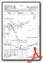
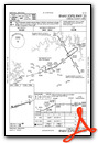
Instrument Approach Procedure (IAP) Charts
Nearby Airports with Instrument Procedures
| ID | Name | Heading / Distance | ||
|---|---|---|---|---|
 |
H34 | Huntsville Municipal Airport | 199° | 19.2 |
|
KFWB | Branson West Municipal - Emerson Field Airport | 029° | 21.8 |
|
KBBG | Branson Airport | 066° | 22.4 |
|
94K | Cassville Municipal Airport | 324° | 23.2 |
|
KROG | Rogers Exec - Carter Field Airport | 268° | 23.4 |
|
KHRO | Boone County Airport | 107° | 23.9 |
|
KPLK | M Graham Clark Downtown Airport | 052° | 24.1 |
|
KASG | Springdale Municipal Airport | 243° | 27.0 |
|
KVBT | Bentonville Municipal/Louise M Thaden Field Airport | 265° | 28.9 |
|
KXNA | Northwest Arkansas Ntl Airport | 259° | 33.7 |
|
KFYV | Drake Field Airport | 229° | 34.8 |
|
2H2 | Jerry Sumners Sr Aurora Municipal Airport | 354° | 35.0 |
Airport Images
Do you have a recent image of this airport? Upload it here!


