Login
Register


4V0
Rangely Airport
Official FAA Data Effective 2024-03-21 0901Z
Chart Supplement

VFR Chart of 4V0
Sectional Charts at SkyVector.com
IFR Chart of 4V0
Enroute Charts at SkyVector.com
Location Information for 4V0
Coordinates: N40°5.64' / W108°45.78'Located 02 miles E of Rangely, Colorado on 327 acres of land. View all Airports in Colorado.
Surveyed Elevation is 5278 feet MSL.
Operations Data
|
|
Airport Communications
| AWOS-3PT: | 119.025 Tel. 970-878-3979 |
|---|---|
| UNICOM: | 122.800 |
| CTAF: | 122.800 |
| ASOS at VEL (40.2 NW): | 118.125 435-781-1224 |
| ASOS at EEO (40.4 E): | 135.525 970-878-5036 |
| ASOS at RIL (58.9 SE): | 135.275 970-625-2206 |
- APCH/DEP CTL SVC PRVDD BY DENVER ARTCC (ZDV) ON 134.5/327.8 GRAND MESA/B/ RCAG.
Nearby Navigation Aids
|
| ||||||||||||||||||||||||||||||||||||

Runway 07/25
| Dimensions: | 6409 x 75 feet / 1953 x 23 meters | |
|---|---|---|
| Surface: | Asphalt in Fair Condition | |
| Weight Limits: | 28 /F/C/X/T, S-28, D-28 | |
| Edge Lighting: | Medium Intensity | |
| Runway 07 | Runway 25 | |
| Coordinates: | N40°5.52' / W108°46.45' | N40°5.75' / W108°45.11' |
| Elevation: | 5237.4 | 5277.8 |
| Traffic Pattern: | Right | Left |
| Runway Heading: | 77° True | 257° True |
| Markings: | Non-Precision Instrument in good condition. | Non-Precision Instrument in good condition. |
| Glide Slope Indicator | P2L (3.00° Glide Path Angle) | |
| REIL: | Yes | Yes |
| Obstacles: | 18 ft Road 788 ft from runway | 21 ft Road 665 ft from runway |
Services Available
| Fuel: | 100LL (blue) |
|---|---|
| Transient Storage: | Tiedowns |
| Airframe Repair: | NONE MINOR EMERGENCY SERVICES UPON REQUEST. |
| Engine Repair: | NONE |
| Bottled Oxygen: | NONE |
| Bulk Oxygen: | NONE |
| Other Services: | PILOT INSTRUCTION |
Ownership Information
| Ownership: | Publicly owned | |
|---|---|---|
| Owner: | RIO BLANCO COUNTY | |
| CO COURTHOUSE PO BOX 599 | ||
| MEEKER, CO 81641 | ||
| 970-878-4001 | ||
| Manager: | WESLEY MILHIM | |
| 2248 E MAIN | ||
| RANGELY, CO 81648 | ||
| 970-675-2316 | ||
Operational Statistics
| Single Engine Aircraft Based on Field: | 14 | Statistics collected for 12 month period ending 2021-12-31 | |
|---|---|---|---|
| Multi-Engine Aircraft Based on Field: | 2 | Annual Commercial Operations: | none |
| Jet Aircraft Based on Field: | none | Annual Commuter Operations: | none |
| Helicopters Based on Field: | none | Annual Air Taxi Operations: | 100 |
| Military Aircraft Based on Field: | none | Annual Military Operations: | 15 |
| Gliders Based on Field: | none | Annual GA Local Operations: | 42000 |
| Ultralights Based on Field: | none | Annual GA Itinerant Operations: | 5000 |
Other Remarks
- THREE FLASHING HAZ BCNS OUTLINE OBSTN HILLS E.
- COLD TEMP ARPT. ALT COR RQRD AT OR BELOW -18C.
- DEER PERIODICALLY ON & INVOF ARPT.
- TWY MARKED WITH BLUE REFLECTORS.
- RWY 07/25 SHOULDERS SOFT WHEN WET.
- RWY 07 HAS 8 FT FENCE LINE 520 FT FM THLD OB, 66 FT TREES 2500 FT FM THLD 600 FT LEFT OF CNTRLN.
- RWY 25 HAS 10 FT FENCE LINE 615 FT FM THLD OB.
- FOR CD IF UNA TO CTC ON FSS FREQ, CTC DENVER ARTCC AT 303-651-4257.
- 0LL SELF SVC FUEL AVBL WITH CREDIT CARD.
- ACTVT REIL RWY 07 & 25; MIRL RWY 07/25 - CTAF. PAPI RWY 07 OPER 24 HRS.
- AUTOMATED UNICOM.
Weather Minimums
Instrument Approach Procedure (IAP) Charts
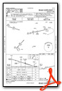
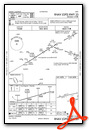
Departure Procedure Obstacles (DPO) Charts
Nearby Airports with Instrument Procedures
| ID | Name | Heading / Distance | ||
|---|---|---|---|---|
 |
KVEL | Vernal Regional Airport | 301° | 40.0 |
|
KEEO | Meeker Coulter Field Airport | 093° | 40.5 |
|
KRIL | Rifle Garfield County Airport | 125° | 58.7 |
|
KGJT | Grand Junction Regional Airport | 169° | 59.3 |
|
74V | Roosevelt Municipal Airport | 280° | 60.3 |
|
KCAG | Craig-Moffat Airport | 066° | 61.9 |
|
KHDN | Yampa Valley Airport | 071° | 74.7 |
|
KDWX | Dixon Airport | 045° | 81.1 |
|
KAJZ | Blake Field Airport | 157° | 84.9 |
|
KEGE | Eagle County Regional Airport | 106° | 89.5 |
|
KSBS | Steamboat Springs/Bob Adams Field Airport | 073° | 90.7 |
|
KRKS | Southwest Wyoming Regional Airport | 351° | 91.0 |
Airport Images
Do you have a recent image of this airport? Upload it here!


