Login
Register


6M2
Horseshoe Bend Airport
Official FAA Data Effective 2024-04-18 0901Z
Chart Supplement

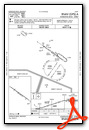
VFR Chart of 6M2
Sectional Charts at SkyVector.com
IFR Chart of 6M2
Enroute Charts at SkyVector.com
Location Information for 6M2
Coordinates: N36°13.28' / W91°45.33'Located 01 miles NE of Horseshoe Bend, Arkansas on 115 acres of land. View all Airports in Arkansas.
Estimated Elevation is 781 feet MSL.
Operations Data
|
|
Airport Communications
| CTAF: | 122.800 |
|---|---|
| UNICOM: | 122.800 |
| AWOS-3PT at 42A (9.7 S): | 121.575 870-916-2768 |
| AWOS-3PT at BVX (30.2 S): | 126.375 870-251-1369 |
| ASOS at BPK (35.7 W): | 133.975 870-481-5946 |
- APCH/DEP SVC PRVDD BY MEMPHIS ARTCC (ZME) ON 120.075/289.4 (WALNUT RIDGE RCAG).
Nearby Navigation Aids
|
| ||||||||||||||||||||||||||||||||||||||||||||||||||||||


Runway 13/31
| Dimensions: | 4502 x 60 feet / 1372 x 18 meters | |
|---|---|---|
| Surface: | Asphalt in Good Condition | |
| Weight Limits: | S-4 | |
| Edge Lighting: | Medium Intensity | |
| Runway 13 | Runway 31 | |
| Coordinates: | N36°13.50' / W91°45.70' | N36°13.07' / W91°44.96' |
| Elevation: | 781.8 | 777.4 |
| Traffic Pattern: | Left | Left |
| Runway Heading: | 125° True | 305° True |
| Displaced Threshold: | 994 Feet | |
| Markings: | Basic in good condition. | Non-Precision Instrument in good condition. |
| Glide Slope Indicator | P2L (3.00° Glide Path Angle) | |
| Obstacles: | 110 ft Trees 1200 ft from runway RAPIDLY RISING TRRN WITH TREES FNA RWY 13. TRRN RISES 681 FT BTN 200-1100 FT FM RWY END. |
32 ft Tree 400 ft from runway, 225 ft right of center |
Services Available
| Fuel: | 100LL (blue) |
|---|---|
| Transient Storage: | Tiedowns |
| Airframe Repair: | MAJOR |
| Engine Repair: | MAJOR |
| Bottled Oxygen: | NOT AVAILABLE |
| Bulk Oxygen: | NOT AVAILABLE |
Ownership Information
| Ownership: | Publicly owned | |
|---|---|---|
| Owner: | CITY OF HORSEHOE BEND | |
| CITY HALL - 704 W COMMERCE | ||
| HORSESHOE BEND, AR 72512 | ||
| 870-670-5113 | ||
| Manager: | ERIC SECRETAN | |
| 704 W COMMERCE | ||
| HORSESHOE BEND, AR 72512 | ||
| 304-268-3666 | ||
Operational Statistics
| Single Engine Aircraft Based on Field: | 14 | Statistics collected for 12 month period ending 2022-01-31 | |
|---|---|---|---|
| Multi-Engine Aircraft Based on Field: | 1 | Annual Commercial Operations: | none |
| Jet Aircraft Based on Field: | none | Annual Commuter Operations: | none |
| Helicopters Based on Field: | none | Annual Air Taxi Operations: | none |
| Military Aircraft Based on Field: | none | Annual Military Operations: | 200 |
| Gliders Based on Field: | none | Annual GA Local Operations: | 2000 |
| Ultralights Based on Field: | none | Annual GA Itinerant Operations: | 3500 |
Other Remarks
- RWY 13 TKOF RCMDD DUE TO RAPIDLY RISING TRRN NW OF ARPT.
- DEER ON & INVOF ARPT.
- FOR CD CTC MEMPHIS ARTCC AT 901-368-8453/8449.
- 0LL SELF SERVE FUEL H24 WITH CREDIT CARD.
- DUSK-DAWN ACTVT MIRL RWY 13/31 - CTAF. PAPI RWY 31 OPR CONSLY.
Weather Minimums

Instrument Approach Procedure (IAP) Charts
Nearby Airports with Instrument Procedures
| ID | Name | Heading / Distance | ||
|---|---|---|---|---|
 |
KCVK | Sharp County Regional Airport | 074° | 9.7 |
|
42A | Melbourne Municipal - John E Miller Field Airport | 201° | 9.7 |
|
7M2 | Mountain View Wilcox Memorial Field Airport | 217° | 26.9 |
|
KBVX | Batesville Regional Airport | 169° | 30.1 |
|
KBPK | Baxter County Airport | 284° | 35.8 |
|
M70 | Pocahontas Municipal Airport | 087° | 38.9 |
|
KUNO | West Plains Regional Airport | 349° | 40.0 |
|
KFLP | Marion County Regional Airport | 276° | 40.7 |
|
KARG | Walnut Ridge Regional Airport | 097° | 40.8 |
|
KHBZ | Heber Springs Municipal Airport | 196° | 44.3 |
|
M19 | Newport Regional Airport | 140° | 44.9 |
|
KMNF | Mountain View Airport | 002° | 46.3 |
Airport Images
Do you have a recent image of this airport? Upload it here!


