Login
Register


6M7
Marianna/Lee County-Steve Edwards Field Airport
Official FAA Data Effective 2024-04-18 0901Z
Chart Supplement

VFR Chart of 6M7
Sectional Charts at SkyVector.com
IFR Chart of 6M7
Enroute Charts at SkyVector.com
Location Information for 6M7
Coordinates: N34°46.97' / W90°48.60'Located 03 miles W of Marianna, Arkansas on 55 acres of land. View all Airports in Arkansas.
Surveyed Elevation is 219 feet MSL.
Operations Data
|
|
Airport Communications
| CTAF: | 122.800 |
|---|---|
| UNICOM: | 122.800 |
| AWOS-3 at DRP (20.3 N): | 120.0 870-630-8144 |
| AWOS-3 at UTA (23.5 E): | 118.075 662-363-1652 |
| AWOS-3 at CKM (32.5 SE): | 120.675 662-624-9777 |
- APCH/DEP SVC PRVDD BY MEMPHIS ARTCC ON FREQS 135.3/335.8 (BRINKLEY RCAG).
Nearby Navigation Aids
|
| ||||||||||||||||||||||||||||||||||||||||||||||||||||||||||||


Runway 18/36
| Dimensions: | 4021 x 75 feet / 1226 x 23 meters | |
|---|---|---|
| Surface: | Asphalt in Fair Condition | |
| Edge Lighting: | Medium Intensity | |
| Runway 18 | Runway 36 | |
| Coordinates: | N34°47.30' / W90°48.59' | N34°46.63' / W90°48.60' |
| Elevation: | 218.6 | 219.0 |
| Runway Heading: | 181° True | 1° True |
| Markings: | Non-Precision Instrument in fair condition. | Non-Precision Instrument in fair condition. |
| Glide Slope Indicator | P2L (3.00° Glide Path Angle) | P2L (3.00° Glide Path Angle) |
| REIL: | Yes | Yes |
| Obstacles: | 75 ft Tree 825 ft from runway, 500 ft right of center | 30 ft Tree 1250 ft from runway, 525 ft left of center |
Services Available
| Fuel: | 100LL (blue) |
|---|---|
| Transient Storage: | Tiedowns |
| Airframe Repair: | NOT AVAILABLE |
| Engine Repair: | NOT AVAILABLE |
| Bottled Oxygen: | NONE |
| Bulk Oxygen: | NONE |
| Other Services: | CROP DUSTING SERVICES |
Ownership Information
| Ownership: | Publicly owned | |
|---|---|---|
| Owner: | CITY OF MARIANNA | |
| 35 SOUTH POPLAR | ||
| MARIANNA, AR 72360 | ||
| 870-295-6089 | ||
| Manager: | DOUG GIBSON | |
| BOX 478 | ||
| MARIANNA, AR 72360 | ||
| 870-295-3485 | ||
Operational Statistics
| Single Engine Aircraft Based on Field: | 9 | Statistics collected for 12 month period ending 2021-08-31 | |
|---|---|---|---|
| Multi-Engine Aircraft Based on Field: | 2 | Annual Commercial Operations: | none |
| Jet Aircraft Based on Field: | none | Annual Commuter Operations: | none |
| Helicopters Based on Field: | none | Annual Air Taxi Operations: | none |
| Military Aircraft Based on Field: | none | Annual Military Operations: | 50 |
| Gliders Based on Field: | none | Annual GA Local Operations: | 21000 |
| Ultralights Based on Field: | none | Annual GA Itinerant Operations: | 4000 |
Other Remarks
- RY 36 75 FT UNLGTD PLINE 2300 FT SOUTH OF THLD.
- NUMEROUS AGRICULTURE OPS FEB-OCT.
- FOR CD CTC MEMPHIS ARTCC AT 901-368-8453/8449.
- 0LL FOR FUEL OTHER HRS CALL 870-295-3485.
- ACTVT REIL RWY 18 & 36; PAPI RWY 18 & 36; MIRL RWY 18/36 - CTAF.
Weather Minimums

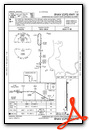
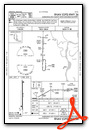
Instrument Approach Procedure (IAP) Charts
Nearby Airports with Instrument Procedures
| ID | Name | Heading / Distance | ||
|---|---|---|---|---|
 |
KHEE | Thompson-Robbins Airport | 151° | 14.0 |
|
M36 | Frank Federer Memorial Airport | 287° | 19.0 |
|
KDRP | Delta Regional Airport | 357° | 20.2 |
|
KUTA | Tunica Municipal Airport | 104° | 23.6 |
|
KCKM | Fletcher Field Airport | 152° | 32.5 |
|
KAWM | West Memphis Municipal Airport | 053° | 35.4 |
|
M60 | Woodruff County Airport | 322° | 37.1 |
|
M73 | Almyra Municipal Airport | 235° | 39.3 |
|
KSGT | Stuttgart Municipal Carl Humphrey Field Airport | 254° | 39.4 |
|
5M1 | Dewitt Municipal/Whitcomb Field Airport | 218° | 39.8 |
|
KMMS | Selfs Airport | 141° | 41.9 |
|
KMEM | Memphis International Airport | 069° | 44.0 |
Airport Images
Do you have a recent image of this airport? Upload it here!


