Login
Register


7D3
Baldwin Municipal Airport
Official FAA Data Effective 2024-04-18 0901Z
Chart Supplement

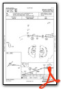
VFR Chart of 7D3
Sectional Charts at SkyVector.com
IFR Chart of 7D3
Enroute Charts at SkyVector.com
Location Information for 7D3
Coordinates: N43°52.53' / W85°50.52'Located 02 miles S of Baldwin, Michigan on 135 acres of land. View all Airports in Michigan.
Estimated Elevation is 828 feet MSL.
Operations Data
|
|
Airport Communications
| CTAF: | 122.900 |
|---|---|
| AWOS-3P at RQB (17.3 SE): | 125.875 231-796-0884 |
| AWOS-3 at LDM (25.1 W): | 119.925 231-843-0459 |
| AWOS-AV at C04 (25.3 SW): | 122.7 231-861-7415 |
- APCH/DEP SVC PRVDD BY MINNEAPOLIS ARTCC ON FREQS 120.85/322.35 (WHITE CLOUD RCAG).
Nearby Navigation Aids
|
| ||||||||||||||||||||||||||||||||||||||||||||||||||||||||||||


Runway 09/27
| Dimensions: | 3800 x 75 feet / 1158 x 23 meters | |
|---|---|---|
| Surface: | Asphalt in Fair Condition | |
| Weight Limits: | S-10 | |
| Runway 09 | Runway 27 | |
| Coordinates: | N43°52.53' / W85°50.76' | N43°52.48' / W85°49.90' |
| Elevation: | 818.0 | 828.0 |
| Traffic Pattern: | Left | Left |
| Runway Heading: | 94° True | 274° True |
| Markings: | Basic in good condition. | Basic in good condition. |
| Obstacles: | 80 ft Trees 1382 ft from runway, 300 ft right of center | |
Runway 05/23
| Dimensions: | 2800 x 100 feet / 853 x 30 meters | |
|---|---|---|
| Surface: | Turf in Fair Condition | |
| Runway 05 | Runway 23 | |
| Coordinates: | N43°52.41' / W85°51.03' | N43°52.73' / W85°50.56' |
| Elevation: | 816.0 | 822.0 |
| Traffic Pattern: | Left | Left |
| Runway Heading: | 47° True | 227° True |
| Displaced Threshold: | 800 Feet | 800 Feet |
| Obstacles: | 63 ft Trees 470 ft from runway, 140 ft left of center | 15 ft Road 267 ft from runway, 77 ft left of center |
Services Available
| Fuel: | NONE |
|---|---|
| Transient Storage: | Tiedowns PILOTS MUST SUP ROPES. |
| Airframe Repair: | NONE |
| Engine Repair: | NONE |
| Bottled Oxygen: | NONE |
| Bulk Oxygen: | NONE |
Ownership Information
| Ownership: | Publicly owned | |
|---|---|---|
| Owner: | VILLAGE OF BALDWIN | |
| PO BOX 339 | ||
| BALDWIN, MI 49304-0339 | ||
| 231-745-3587 | ||
| Manager: | MAC L MCCLELLAN | |
| 7668 S M-37 | ||
| BALDWIN, MI 49304 | ||
| 231-745-7815 | CELL 231-250-2551. | |
Operational Statistics
| Single Engine Aircraft Based on Field: | 2 | Statistics collected for 12 month period ending 2019-12-31 | |
|---|---|---|---|
| Multi-Engine Aircraft Based on Field: | none | Annual Commercial Operations: | none |
| Jet Aircraft Based on Field: | none | Annual Commuter Operations: | none |
| Helicopters Based on Field: | none | Annual Air Taxi Operations: | none |
| Military Aircraft Based on Field: | none | Annual Military Operations: | none |
| Gliders Based on Field: | none | Annual GA Local Operations: | none |
| Ultralights Based on Field: | none | Annual GA Itinerant Operations: | 320 |
Other Remarks
- THIS AIRPORT HAS BEEN SURVEYED BY THE NATIONAL GEODETIC SURVEY.
- DEER ON & INVOF ARPT.
- UAS OPS ADJ TO RWY 09/27.
- GATE 5-3-2-1.
- FOR CD CTC MINNEAPOLIS ARTCC AT 651-463-5588.
- ARPT CLSD WHEN SNOW COVD - NO SNOW REMOVAL.
- RWY & DTHR MKD WITH 3 FT YELLOW CONES.
- RWY & DTHR MKD WITH 3 FT YELLOW CONES.
Weather Minimums

Instrument Approach Procedure (IAP) Charts
Nearby Airports with Instrument Procedures
| ID | Name | Heading / Distance | ||
|---|---|---|---|---|
 |
KRQB | Roben-Hood Airport | 121° | 17.3 |
|
KLDM | Mason County Airport | 282° | 25.1 |
|
C04 | Oceana County Airport | 236° | 25.4 |
|
KFFX | Fremont Municipal Airport | 194° | 27.0 |
|
KMBL | Manistee County/Blacker Airport | 323° | 29.6 |
|
KCAD | Wexford County Airport | 037° | 30.2 |
|
13C | Lakeview/Griffith Field Airport | 135° | 35.7 |
|
8D4 | Paul C Miller/Sparta Airport | 170° | 45.4 |
|
KMKG | Muskegon County Airport | 202° | 45.8 |
|
KFKS | Frankfort Dow Memorial Field Airport | 341° | 47.6 |
|
48D | Clare Municipal Airport | 092° | 47.9 |
|
KMOP | Mount Pleasant Municipal Airport | 107° | 50.4 |
Airport Images
Do you have a recent image of this airport? Upload it here!


