Login
Register


7M1
Mc Gehee Municipal Airport
Official FAA Data Effective 2024-04-18 0901Z
Chart Supplement

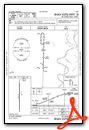
VFR Chart of 7M1
Sectional Charts at SkyVector.com
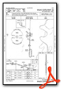
IFR Chart of 7M1
Enroute Charts at SkyVector.com
Location Information for 7M1
Coordinates: N33°37.21' / W91°21.89'Located 02 miles E of Mc Gehee, Arkansas on 84 acres of land. View all Airports in Arkansas.
Surveyed Elevation is 141 feet MSL.
Operations Data
|
|
Airport Communications
| CTAF: | 122.900 |
|---|---|
| ASOS at LLQ (19.3 W): | 133.325 870-367-1019 |
| ASOS at GLH (20.7 SE): | 125.525 662-332-0863 |
| AWOS-3PT at RNV (31.5 E): | 124.175 662-843-3021 |
- APCH/DEP SVC PRVDD BY MEMPHIS ARTCC ON FREQS 135.875/269.35 (GREENVILLE RCAG & PINE BLUFF RCAG).
Nearby Navigation Aids
|
| ||||||||||||||||||||||||||||||||||||||||||||||||||||||||||||


Runway 18/36
| Dimensions: | 4007 x 75 feet / 1221 x 23 meters | |
|---|---|---|
| Surface: | Asphalt in Fair Condition | |
| Weight Limits: | S-12 | |
| Edge Lighting: | Medium Intensity | |
| Runway 18 | Runway 36 | |
| Coordinates: | N33°37.54' / W91°21.88' | N33°36.88' / W91°21.90' |
| Elevation: | 141.0 | 141.0 |
| Traffic Pattern: | Left | Left |
| Runway Heading: | 181° True | 1° True |
| Markings: | Non-Precision Instrument in fair condition. | Non-Precision Instrument in fair condition. |
| Obstacles: | 33 ft Trees 600 ft from runway, 300 ft right of center DITCH 100 FT B0TH SIDES OF EXTDD CNTRLN APRXLY 3 FT DEEP. |
EROSION FM END OF CULVERT TOWARD CNTR, BOTH SIDES 6 FT LONG 1-3 FT DEEP. |
Services Available
| Fuel: | 100LL (blue), Jet-A |
|---|---|
| Transient Storage: | Tiedowns |
| Airframe Repair: | NOT AVAILABLE |
| Engine Repair: | NOT AVAILABLE |
| Bottled Oxygen: | NONE |
| Bulk Oxygen: | NONE |
| Other Services: | CROP DUSTING SERVICES |
Ownership Information
| Ownership: | Publicly owned | |
|---|---|---|
| Owner: | CITY OF MC GEHEE | |
| P.O. BOX 612 | ||
| MC GEHEE, AR 71654 | ||
| 870-222-3160 | ||
| Manager: | BILL SIMMONS | |
| P.O. BOX 612 | ||
| MC GEHEE, AR 71654 | ||
| 870-919-5172 | ||
Operational Statistics
| Single Engine Aircraft Based on Field: | 10 | Statistics collected for 12 month period ending 2022-04-30 | |
|---|---|---|---|
| Multi-Engine Aircraft Based on Field: | none | Annual Commercial Operations: | none |
| Jet Aircraft Based on Field: | none | Annual Commuter Operations: | none |
| Helicopters Based on Field: | none | Annual Air Taxi Operations: | none |
| Military Aircraft Based on Field: | none | Annual Military Operations: | 100 |
| Gliders Based on Field: | none | Annual GA Local Operations: | 20000 |
| Ultralights Based on Field: | none | Annual GA Itinerant Operations: | 5000 |
Other Remarks
- THIS AIRPORT HAS BEEN SURVEYED BY THE NATIONAL GEODETIC SURVEY.
- RY 36 TURNAROUND HAS 3-4 FT DROP-OFF ON EAST & NORTH SIDE.
- NUMEROUS AGRICULTURE ACFT OPS FROM FEB-NOV 500 FT AGL AND BELOW.
- FOR CD CTC MEMPHIS ARTCC AT 901-368-8453/8449.
- LAND PURCHASED
- 0LL 24 HR SELF SERVICE FUEL AVBL WITH CREDIT CARD.
Weather Minimums

Instrument Approach Procedure (IAP) Charts
Nearby Airports with Instrument Procedures
| ID | Name | Heading / Distance | ||
|---|---|---|---|---|
 |
M32 | Lake Village Municipal Airport | 171° | 16.6 |
|
0M0 | Billy Free Municipal Airport | 331° | 18.0 |
|
KLLQ | Monticello Municipal/Ellis Field Airport | 273° | 19.4 |
|
KGLH | Greenville Mid-Delta Airport | 112° | 20.7 |
|
KRNV | Cleveland Municipal Airport | 074° | 31.6 |
|
KIDL | Indianola Municipal Airport | 102° | 35.3 |
|
3M9 | Warren Municipal Airport | 264° | 36.3 |
|
KCRT | Z M Jack Stell Field Airport | 224° | 37.0 |
|
5M1 | Dewitt Municipal/Whitcomb Field Airport | 004° | 38.6 |
|
M37 | Ruleville-Drew Airport | 077° | 43.1 |
|
KPBF | Pinebluff Regional/Grider Field Airport | 319° | 43.8 |
|
M73 | Almyra Municipal Airport | 354° | 47.7 |
Airport Images
Do you have a recent image of this airport? Upload it here!


