Login
Register


8D1
New Holstein Municipal Airport
Official FAA Data Effective 2024-04-18 0901Z
Chart Supplement

VFR Chart of 8D1
Sectional Charts at SkyVector.com
IFR Chart of 8D1
Enroute Charts at SkyVector.com
Location Information for 8D1
Coordinates: N43°56.65' / W88°6.89'Located 01 miles W of New Holstein, Wisconsin on 267 acres of land. View all Airports in Wisconsin.
Surveyed Elevation is 992 feet MSL.
Operations Data
|
|
Airport Communications
| MILWAUKEE APPROACH: | 127.0 263.075 |
|---|---|
| MILWAUKEE DEPARTURE: | 127.0 263.075 |
| UNICOM: | 123.000 |
| CTAF: | 123.000 |
| ASOS at SBM (15.5 SE): | 118.425 920-467-0744 |
| ASOS at OSH (19.2 W): | 920-426-1644 |
| ASOS at FLD (19.2 SW): | 134.0 920-922-4444 |
Nearby Navigation Aids
|
| ||||||||||||||||||||||||||||||||||||||||||||||||||||||||||||


Runway 14/32
| Dimensions: | 3600 x 75 feet / 1097 x 23 meters | |
|---|---|---|
| Surface: | Asphalt in Excellent Condition | |
| Weight Limits: | S-20 | |
| Edge Lighting: | Medium Intensity | |
| Runway 14 | Runway 32 | |
| Coordinates: | N43°56.89' / W88°7.06' | N43°56.42' / W88°6.55' |
| Elevation: | 976.6 | 976.5 |
| Traffic Pattern: | Left | Left |
| Runway Heading: | 141° True | 321° True |
| Markings: | Non-Precision Instrument in fair condition. | Non-Precision Instrument in fair condition. |
| Glide Slope Indicator | P2L (3.20° Glide Path Angle) | P2L (3.00° Glide Path Angle) |
| REIL: | Yes | Yes |
| Obstacles: | 65 ft Trees 1240 ft from runway, 385 ft right of center | |
Runway 04/22
NOT PLOWED, CFM CONDS WITH AMGR. | ||
| Dimensions: | 2951 x 250 feet / 899 x 76 meters | |
|---|---|---|
| Surface: | Turf in Fair Condition | |
| Runway 04 | Runway 22 | |
| Coordinates: | N43°56.45' / W88°7.21' | N43°56.82' / W88°6.77' |
| Elevation: | 992.1 | 973.6 |
| Traffic Pattern: | Left | Right |
| Runway Heading: | 41° True | 221° True |
| Markings: | None | None |
| Obstacles: | 63 ft Trees 935 ft from runway, 200 ft left of center | |
Services Available
| Fuel: | 100LL (blue) |
|---|---|
| Transient Storage: | Hangars,Tiedowns |
| Airframe Repair: | MAJOR |
| Engine Repair: | MAJOR |
| Bottled Oxygen: | NOT AVAILABLE |
| Bulk Oxygen: | NOT AVAILABLE |
Ownership Information
| Ownership: | Publicly owned | |
|---|---|---|
| Owner: | CITY OF NEW HOLSTEIN | |
| 2110 WASHINGTON ST | ||
| NEW HOLSTEIN, WI 53061 | ||
| 920-898-5766 | ||
| Manager: | PERRY WELCH | |
| 2110 WASHINGTON ST | ||
| NEW HOLSTEIN, WI 53061 | ||
| 920-219-0015 | ||
Operational Statistics
| Single Engine Aircraft Based on Field: | 21 | Statistics collected for 12 month period ending 2023-06-15 | |
|---|---|---|---|
| Multi-Engine Aircraft Based on Field: | none | Annual Commercial Operations: | none |
| Jet Aircraft Based on Field: | none | Annual Commuter Operations: | none |
| Helicopters Based on Field: | none | Annual Air Taxi Operations: | 200 |
| Military Aircraft Based on Field: | none | Annual Military Operations: | 200 |
| Gliders Based on Field: | none | Annual GA Local Operations: | 4000 |
| Ultralights Based on Field: | none | Annual GA Itinerant Operations: | 3500 |
Other Remarks
- NUMEROUS BIRDS INVOF ARPT.
- FOR CD CTC CHICAGO ARTCC AT 630-906-8921.
- MKD WITH ORANGE/WHITE A-FRAMES.
- MKD WITH ORANGE/WHITE A-FRAMES.
- 0LL 24 HR SELF SVC FUEL WITH CREDIT CARD.
- TO INCR INTST & ACTVT REIL RWY 14/32; PAPI RWY 14/32; MIRL RWY 14/32 PRESET TO LOW SS-SR - CTAF.
Weather Minimums
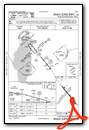
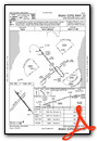
Instrument Approach Procedure (IAP) Charts
Nearby Airports with Instrument Procedures
| ID | Name | Heading / Distance | ||
|---|---|---|---|---|
 |
KSBM | Sheboygan County Memorial Airport | 132° | 15.5 |
|
KFLD | Fond Du Lac County Airport | 237° | 19.3 |
|
KOSH | Wittman Regional Airport | 277° | 19.3 |
|
KMTW | Manitowoc County Airport | 059° | 21.8 |
|
KATW | Appleton International Airport | 317° | 25.7 |
|
KETB | West Bend Municipal Airport | 181° | 31.3 |
|
KGRB | Green Bay/Austin Straubel International Airport | 358° | 32.4 |
|
KHXF | Hartford Municipal Airport | 198° | 37.6 |
|
KUNU | Dodge County Airport | 219° | 40.3 |
|
KPCZ | Waupaca Municipal Airport | 301° | 45.5 |
|
KCLI | Clintonville Municipal Airport | 326° | 48.1 |
|
KMWC | Lawrence J Timmerman Airport | 175° | 50.1 |
Airport Images

By: Big Orange Bird


