Login
Register


9A5
Barwick Lafayette Airport
Official FAA Data Effective 2024-04-18 0901Z
Chart Supplement

VFR Chart of 9A5
Sectional Charts at SkyVector.com
IFR Chart of 9A5
Enroute Charts at SkyVector.com
Location Information for 9A5
Coordinates: N34°41.30' / W85°17.42'Located 01 miles S of Lafayette, Georgia on 20 acres of land. View all Airports in Georgia.
Surveyed Elevation is 776 feet MSL.
Operations Data
|
|
Airport Communications
| AWOS-3: | 119.775 Tel. 706-639-1976 |
|---|---|
| CHATTANOOGA APPROACH: | 125.1 379.1 |
| CHATTANOOGA DEPARTURE: | 125.1 379.1 |
| UNICOM: | 122.800 |
| CTAF: | 122.800 |
| AWOS-3PT at DNN (20.8 E): | 127.65 706-278-7010 |
| ASOS at CHA (21.2 N): | 119.85 423-499-5973 |
| ATIS at CHA (21.3 N): | 119.85 |
- APCH/DEP SVC PRVDD BY ATLANTA ARTCC ON FREQS 124.5/270.325 (GADSDEN RCAG) WHEN CHATTANOOGA APCH CTL CLSD.
Nearby Navigation Aids
|
| ||||||||||||||||||||||||||||||||||||||||||||||||||||||


Runway 02/20
| Dimensions: | 5415 x 75 feet / 1650 x 23 meters | |
|---|---|---|
| Surface: | Asphalt in Fair Condition | |
| Weight Limits: | S-20 | |
| Edge Lighting: | Medium Intensity | |
| Runway 02 | Runway 20 | |
| Coordinates: | N34°40.88' / W85°17.60' | N34°41.72' / W85°17.24' |
| Elevation: | 769.2 | 774.1 |
| Traffic Pattern: | Left | Left |
| Runway Heading: | 20° True | 199° True |
| Displaced Threshold: | 65 Feet | 449 Feet |
| Declared Distances: | TORA:5415 TODA:5415 ASDA:5415 LDA:5350 | TORA:5415 TODA:5415 ASDA:5415 LDA:4966 |
| Markings: | Non-Precision Instrument in poor condition. | Non-Precision Instrument in poor condition. |
| Glide Slope Indicator | P2R (3.75° Glide Path Angle) | P2R (3.75° Glide Path Angle) |
| Obstacles: | 37 ft Trees 311 ft from runway, 264 ft right of center | 32 ft Building 264 ft from runway, 157 ft right of center 0:1 AT DSPLCD THR - RR TRACK -150 FT RIGHT. 4 FT BERM 90 FT LEFT OF CNTRLN FROM DSPLCD THR TO 200 FT FROM EOR. |
Services Available
| Fuel: | 100LL (blue) |
|---|---|
| Transient Storage: | Tiedowns |
| Airframe Repair: | MAJOR |
| Engine Repair: | MAJOR |
| Bottled Oxygen: | HIGH/LOW |
| Bulk Oxygen: | NONE |
| Other Services: | PILOT INSTRUCTION |
Ownership Information
| Ownership: | Publicly owned | |
|---|---|---|
| Owner: | CITY OF LAFAYETTE | |
| P.O. BOX 89 | ||
| LAFAYETTE, GA 30728 | ||
| (706) 638-7071 | ||
| Manager: | VERNON BARNETT | |
| 141 GASQUE DR | ||
| LAFAYETTE, GA 30728 | ||
| (706) 638-7071 | ||
Operational Statistics
| Single Engine Aircraft Based on Field: | 33 | Statistics collected for 12 month period ending 2022-12-31 | |
|---|---|---|---|
| Multi-Engine Aircraft Based on Field: | 3 | Annual Commercial Operations: | none |
| Jet Aircraft Based on Field: | none | Annual Commuter Operations: | none |
| Helicopters Based on Field: | none | Annual Air Taxi Operations: | none |
| Military Aircraft Based on Field: | none | Annual Military Operations: | 100 |
| Gliders Based on Field: | none | Annual GA Local Operations: | 3650 |
| Ultralights Based on Field: | none | Annual GA Itinerant Operations: | 4000 |
Other Remarks
- RR TRACKS PARL W SIDE OF RWY 115 FT FROM CNTRLN.
- DEER AND OTHER WILDLIFE ON & INVOF RWY & ARPT.
- RWY 02/20 IS DESIGNED FOR AIRCRAFT WITH WINGSPAN LESS THAN 49 FEET (GROUP A-I AND SMALLER).
- FOR CD CTC CHATTANOOGA APCH AT 423-855-6478, WHEN APCH CLSD CTC ATLANTA ARTCC AT 770-210-7692.
- MARKINGS FADED BADLY.
- MARKINGS FADED BADLY.
- MIRL RWY 02/20 PRESET MED INTST. TO INCR INTST & ACTVT PAPI RWY 02; MIRL RWY 02/20 - CTAF.
Weather Minimums

Instrument Approach Procedure (IAP) Charts
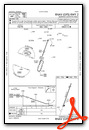
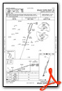
Nearby Airports with Instrument Procedures
| ID | Name | Heading / Distance | ||
|---|---|---|---|---|
 |
KDNN | Dalton Municipal Airport | 084° | 20.9 |
|
KCHA | Lovell Field Airport | 011° | 21.2 |
|
KRMG | Richard B Russell Regional - J H Towers Field Airport | 162° | 21.3 |
|
KCZL | Tom B David Field Airport | 128° | 22.3 |
|
4A9 | Isbell Field Airport | 239° | 24.9 |
|
KAPT | Marion County/Brown Field Airport | 326° | 26.6 |
|
4A6 | Scottsboro Municipal-Word Field Airport | 270° | 35.4 |
|
49A | Gilmer County Airport | 095° | 38.0 |
|
KPYP | Centre-Piedmont-Cherokee County Regional Airport | 203° | 39.2 |
|
KRZR | Cleveland Regional Jetport Airport | 037° | 39.6 |
|
KVPC | Cartersville Airport | 146° | 40.3 |
|
4A4 | Polk County/Cornelius Moore Field Airport | 169° | 40.8 |


