Login
Register


AAS
Taylor County Airport
Official FAA Data Effective 2024-04-18 0901Z
Chart Supplement

VFR Chart of KAAS
Sectional Charts at SkyVector.com
IFR Chart of KAAS
Enroute Charts at SkyVector.com
Location Information for KAAS
Coordinates: N37°21.50' / W85°18.57'Located 02 miles NE of Campbellsville, Kentucky on 106 acres of land. View all Airports in Kentucky.
Surveyed Elevation is 920 feet MSL.
Operations Data
|
|
Airport Communications
| AWOS-3: | 121.125 Tel. 270-789-1985 |
|---|---|
| UNICOM: | 122.700 |
| CTAF: | 122.700 |
| AWOS-3P at 6I2 (16.9 N): | 119.725 859-336-0340 |
| AWOS-3 at K24 (23.1 SE): | 119.6 270-343-5556 |
| AWOS-3 at BRY (28.5 N): | 119.925 502-348-1867 |
- APCH/DEP SVC PRVDD BY INDIANAPOLIS ARTCC ON FREQS 121.175/353.65 (NEW HOPE RCAG).
Nearby Navigation Aids
|
| ||||||||||||||||||||||||||||||||||||||||||||||||||||||||||||


Runway 05/23
TREES BOTH SIDES OF RWY VIOLATE 7:1 TRSNL SFC. | ||
| Dimensions: | 5003 x 75 feet / 1525 x 23 meters | |
|---|---|---|
| Surface: | Asphalt in Good Condition | |
| Weight Limits: | 14 /F/D/X/T, S-37, D-49 | |
| Edge Lighting: | Medium Intensity | |
| Runway 05 | Runway 23 | |
| Coordinates: | N37°21.23' / W85°18.96' | N37°21.76' / W85°18.17' |
| Elevation: | 870.7 | 920.5 |
| Traffic Pattern: | Left | Left |
| Runway Heading: | 50° True | 230° True |
| Markings: | Non-Precision Instrument in good condition. | Non-Precision Instrument in good condition. |
| Glide Slope Indicator | P4L (3.50° Glide Path Angle) | P4L (3.25° Glide Path Angle) |
| REIL: | Yes | Yes |
| Obstacles: | 61 ft Trees 1143 ft from runway, 374 ft left of center | 111 ft Trees 3472 ft from runway, 867 ft left of center |
Services Available
| Fuel: | 100LL (blue), Jet A+ |
|---|---|
| Transient Storage: | Hangars,Tiedowns |
| Airframe Repair: | MINOR |
| Engine Repair: | MINOR |
| Bottled Oxygen: | NOT AVAILABLE |
| Bulk Oxygen: | NOT AVAILABLE |
Ownership Information
| Ownership: | Publicly owned | |
|---|---|---|
| Owner: | AIRPORT BOARD | JOHN KERR |
| PO BOX 1093 | ||
| CAMPBELLSVILLE, KY 42719 | ||
| 270-403-4135 | ||
| Manager: | CARL WATSON | |
| 360 AIRPORT ROAD | ||
| CAMPBELLSVILLE, KY 42718 | ||
| 270-789-4182 | ||
Operational Statistics
| Single Engine Aircraft Based on Field: | 14 | Statistics collected for 12 month period ending 2018-04-04 | |
|---|---|---|---|
| Multi-Engine Aircraft Based on Field: | none | Annual Commercial Operations: | none |
| Jet Aircraft Based on Field: | none | Annual Commuter Operations: | none |
| Helicopters Based on Field: | none | Annual Air Taxi Operations: | 1410 |
| Military Aircraft Based on Field: | none | Annual Military Operations: | 870 |
| Gliders Based on Field: | none | Annual GA Local Operations: | 3320 |
| Ultralights Based on Field: | none | Annual GA Itinerant Operations: | 4730 |
Other Remarks
- FOR CD CTC INDIANAPOLIS ARTCC AT 317-247-2411.
- 0LL AVBL AFT HR WITH CREDIT CARD.
- ACVT REIL RWY 05 & 23; PAPI RWY 05 & 23- CTAF; MIRL RWY 05/23 PRESET ON LOW INTST; INCR INTST - CTAF.
Weather Minimums
Instrument Approach Procedure (IAP) Charts
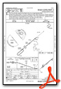
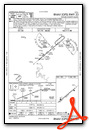
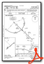
Nearby Airports with Instrument Procedures
| ID | Name | Heading / Distance | ||
|---|---|---|---|---|
 |
6I2 | Lebanon Springfield-George Hoerter Field Airport | 011° | 16.8 |
|
K24 | Russell County Airport | 154° | 23.1 |
|
KBRY | Samuels Field Airport | 341° | 28.8 |
|
KDVK | Stuart Powell Field Airport | 062° | 28.9 |
|
KEKX | Addington Field Airport | 303° | 35.3 |
|
KGLW | Glasgow Municipal Airport | 237° | 36.6 |
|
KEKQ | Wayne County Airport | 144° | 37.2 |
|
KSME | Lake Cumberland Regional Airport | 118° | 37.9 |
|
KTZV | Tompkinsville/Monroe County Airport | 203° | 41.1 |
|
M20 | Leitchfield-Grayson County Airport | 273° | 45.6 |
|
KFTK | Godman AAF Airport | 316° | 45.6 |
|
KRGA | Central Kentucky Regional Airport | 070° | 49.4 |
Airport Images

By: 2flaps

By: 2flaps


Comments
Taxiway extension
Both online maps applications and the chart supplement diagram as of Oct. 2023 are out of date, showing a taxiway that formerly ended short of Rwy 23 with a somwhat complicated intersection. These appear to be old images predating an airport improvement for which a $500,000 grant was awarded in 2020. For most of 2023, at least, the airport has had an extended and simplified taxiway configuration allowing taxi to and from the very end of Rwy 23. This is visible on the 2 pix I have posted.