Login
Register


ABQ
Albuquerque International Sunport Airport
Official FAA Data Effective 2024-04-18 0901Z
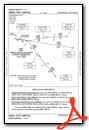
From the Flight Deck
Chart Supplement

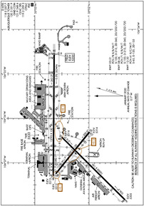
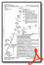
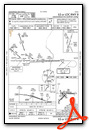
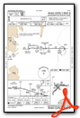
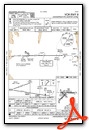
KABQ Airport Diagram
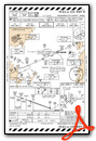
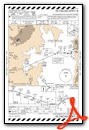
VFR Chart of KABQ
Sectional Charts at SkyVector.com
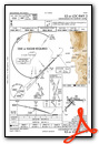
IFR Chart of KABQ
Enroute Charts at SkyVector.com
Location Information for KABQ
Coordinates: N35°2.34' / W106°36.50'Located 03 miles SE of Albuquerque, New Mexico on 2039 acres of land. View all Airports in New Mexico.
Surveyed Elevation is 5354 feet MSL.
Operations Data
|
|
Airport Communications
| D-ATIS: | 118.0 (505-856-4928) 257.7 (505-856-4928) |
|---|---|
| ASOS: | Tel. 505-242-4044 |
| ALBUQUERQUE TOWER: | 120.3 123.775 351.9 |
| ALBUQUERQUE GROUND: | 121.9 348.6 |
| ALBUQUERQUE APPROACH: | 123.9 ;SOUTH OF V12 126.3 127.4 ;ON OR NORTH OF V12 253.5 ;ON OR NORTH OF V12 354.1 ;SOUTH OF V12 |
| ALBUQUERQUE DEPARTURE: | 123.9 ;SOUTH OF V12 127.4 ;ON OR NORTH OF V12 253.5 ;ON OR NORTH OF V12 354.1 ;SOUTH OF V12 |
| IC: | 123.9 ;SOUTH OF V12 354.1 ;SOUTH OF V12 |
| CLEARANCE DELIVERY: | 119.2 259.3 |
| EMERG: | 121.5 243.0 |
| CLASS C: | 123.9 ;SOUTH OF V12 127.4 ;ON OR NORTH OF V12 253.5 ;ON OR NORTH OF V12 354.1 ;SOUTH OF V12 |
| CURLY STAR: | 127.4 253.5 |
| MIERA STAR: | 123.9 354.1 |
| PTD: | 372.2 |
| LAVAN STAR: | 123.9 354.1 |
| UNICOM: | 122.950 |
| PMSV METRO: | 342.3 |
| AWOS-3PT at AEG (11.2 NW): | 505-842-2009 |
| ATIS at AEG (11.2 NW): | 119.025 |
| AWOS-3PT at BRG (26.1 SW): | 118.55 505-864-4375 |
- OTHER OPNS CALLS ARE KING/JOLLY/SAVE AND TAM OPERATED BY ANG AND NAVY.
- PMSV OTS UFN - LTD BLW 10000 FT, 010-070.
- PTD OTS UFN.
Nearby Navigation Aids
|
| ||||||||||||||||||||||||||||||||||||||||||


Runway 08/26
| Dimensions: | 13793 x 150 feet / 4204 x 46 meters | |
|---|---|---|
| Surface: | Concrete / Grooved in Good Condition RWY 08/26, 03/21 & 12/30 GROOVED 130 FT WIDE. | |
| Weight Limits: | 71 /R/B/W/T, S-100, D-210, ST-360, DT-720 | |
| Edge Lighting: | High Intensity | |
| Runway 08 | Runway 26 | |
| Coordinates: | N35°2.66' / W106°37.30' | N35°2.64' / W106°34.53' |
| Elevation: | 5311.9 | 5354.9 |
| Traffic Pattern: | Right | Left |
| Runway Heading: | 90° True | 270° True |
| Displaced Threshold: | 1000 Feet | |
| Declared Distances: | TORA:13793 TODA:13793 ASDA:13793 LDA:12793 | TORA:13793 TODA:13793 ASDA:13793 LDA:13793 |
| Markings: | Precision Instrument in good condition. | Precision Instrument in good condition. |
| Glide Slope Indicator | V6L (2.95° Glide Path Angle) | P4L (3.00° Glide Path Angle) PAPI DOES NOT PROVIDE OBST CLEARANCE BYD 3.5 NM FROM THR, UNUSBL BYD 3.5 NM. |
| RVR Equipment | Touchdown | Rollout |
| Approach Lights: | MALSR 1,400 Foot Medium-intensity Approach Lighting System with runway alignment indicator lights. | |
| REIL: | Yes | |
| Centerline Lights: | Yes | Yes |
Runway 03/21
| Dimensions: | 10000 x 150 feet / 3048 x 46 meters | |
|---|---|---|
| Surface: | Concrete / Grooved in Good Condition | |
| Weight Limits: | 78 /R/B/W/T, S-100, D-210, ST-360, DT-720 | |
| Edge Lighting: | High Intensity | |
| Runway 03 | Runway 21 | |
| Coordinates: | N35°1.33' / W106°37.84' | N35°2.50' / W106°36.42' |
| Elevation: | 5305.1 | 5316.1 |
| Traffic Pattern: | Right | Left |
| Runway Heading: | 45° True | 225° True |
| Declared Distances: | TORA:10000 TODA:10000 ASDA:10000 LDA:10000 | TORA:10000 TODA:10000 ASDA:10000 LDA:10000 |
| Markings: | Precision Instrument in good condition. | Precision Instrument in good condition. |
| Glide Slope Indicator | P4L (3.00° Glide Path Angle) | P4L (3.00° Glide Path Angle) |
| RVR Equipment | Touchdown Rollout | Touchdown Rollout |
| Approach Lights: | MALSR 1,400 Foot Medium-intensity Approach Lighting System with runway alignment indicator lights. | |
| REIL: | Yes | |
| Centerline Lights: | Yes | Yes |
Runway 12/30
| Dimensions: | 6000 x 150 feet / 1829 x 46 meters | |
|---|---|---|
| Surface: | Concrete / Grooved in Good Condition | |
| Weight Limits: | 41 /R/C/W/T, S-65, D-120, ST-155 | |
| Edge Lighting: | Medium Intensity | |
| Runway 12 | Runway 30 | |
| Coordinates: | N35°2.61' / W106°37.25' | N35°1.99' / W106°36.31' |
| Elevation: | 5312.4 | 5313.6 |
| Traffic Pattern: | Right | Left |
| Runway Heading: | 129° True | 309° True |
| Declared Distances: | TORA:6000 TODA:6000 ASDA:6000 LDA:6000 | TORA:6000 TODA:6000 ASDA:6000 LDA:6000 |
| Markings: | Basic in good condition. | Basic in good condition. |
| Glide Slope Indicator | P4L (3.00° Glide Path Angle) | |
| RVR Equipment | Rollout | Touchdown |
| REIL: | Yes | |
Services Available
| Fuel: | 100LL (blue), Jet-A, Jet A-1, Jet A-1+ |
|---|---|
| Transient Storage: | Hangars,Tiedowns |
| Airframe Repair: | MAJOR |
| Engine Repair: | MAJOR |
| Bottled Oxygen: | HIGH/LOW |
| Bulk Oxygen: | HIGH/LOW |
| Other Services: | AIR AMBULANCE SERVICES,AVIONICS,CARGO HANDLING SERVICES,CHARTER SERVICE,PILOT INSTRUCTION,AIRCRAFT RENTAL,AIRCRAFT SALES,ANNUAL SURVEYING |
Ownership Information
| Ownership: | Publicly owned | |
|---|---|---|
| Owner: | CITY OF ALBUQUERQUE | |
| PO BOX 1293 | ||
| ALBUQUERQUE, NM 87103 | ||
| 505-768-3000 | ||
| Manager: | RICHARD MCCURLEY | RICHARD MCCURLEY |
| PO BOX 9948 | ||
| ALBUQUERQUE, NM 87119 | ||
| 505-244-7700 | ||
Operational Statistics
| Single Engine Aircraft Based on Field: | 38 | Statistics collected for 12 month period ending 2023-02-28 | |
|---|---|---|---|
| Multi-Engine Aircraft Based on Field: | 52 | Annual Commercial Operations: | 45724 |
| Jet Aircraft Based on Field: | 55 | Annual Commuter Operations: | none |
| Helicopters Based on Field: | 21 | Annual Air Taxi Operations: | 24909 |
| Military Aircraft Based on Field: | 34 | Annual Military Operations: | 19120 |
| Gliders Based on Field: | none | Annual GA Local Operations: | 16813 |
| Ultralights Based on Field: | none | Annual GA Itinerant Operations: | 36073 |
Other Remarks
- AIR CARRIER GND HANDLING NOT AVBL BTN THE HRS OF 0100-0430.
- BIRD HAZARD OCT-DEC & MAR-MAY.
- TWY H MILITARY USE ONLY.
- FTR ACFT DEP S ONLY.
- DEPS ON RWY 03 ARE RSTRD AND RQR PRIOR COORDN WITH ATCT.
- TWY E5 CLSD
- SERVICE-FUEL: A++(MIL), A++100(MIL).
- MIL WX SVC AVBL 1100-2300Z++ MON, TUE-FRI 1300-2300Z++. CLSD WKNDS & HOL/MIL DOWN DAYS. MSN WX SUPPORT BRIEFINGS FOR AIRCREW AVBL VIA THE 25 OWS/DAVIS-MONTHAN AFB DUR MIL WX FLT CLSD HR, DSN 228-6604M /C520-228-6604. WX FCST BY NWS KABQ. DSN 246-9707 AND C505-846-9707. H24 OBSN BY FAA C505-246-4200.
- RWY 08 AND 12 APCH ENDS ARE DE-COUPLED. COMMON HOLD SHORT LINE IS SHARED. RWY 12 FOR TAKEOFF IS ONLY AVBL VIA TXY E. FULL LENGTH AVBL VIA BACK TAXI. RWY 30 LANDINGS, LAST AVBL EXIT IS TXY E, EXIT VIA E1 IS NOT POSSIBLE.
- HVY STUDENT COPTER TFC; CTL FIRING AREA S OF ARPT.
- ARFF PROVIDED BY USAF.
Weather Minimums

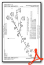
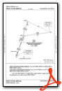
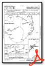
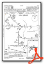
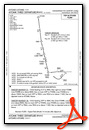
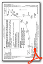
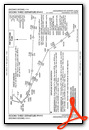
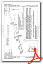
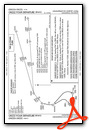
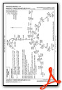
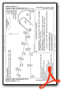
Standard Terminal Arrival (STAR) Charts
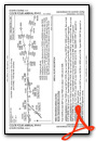

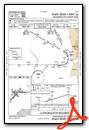
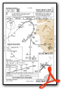
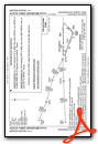
Instrument Approach Procedure (IAP) Charts
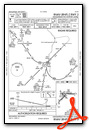
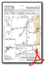

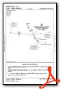
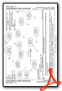
Departure Procedure (DP) Charts

Nearby Airports with Instrument Procedures
| ID | Name | Heading / Distance | ||
|---|---|---|---|---|
 |
KAEG | Double Eagle II Airport | 304° | 11.2 |
|
KBRG | Belen Regional Airport | 205° | 26.1 |
|
0E0 | Moriarty Municipal Airport | 096° | 30.2 |
|
KSAF | Santa Fe Regional Airport | 036° | 43.0 |
|
KLAM | Los Alamos Airport | 018° | 53.0 |
|
KONM | Socorro Municipal Airport | 193° | 62.6 |
|
KGNT | Grants-Milan Municipal Airport | 277° | 64.2 |
|
KLVS | Las Vegas Municipal Airport | 062° | 80.8 |
|
KSKX | Taos Regional Airport | 028° | 96.2 |
|
KAXX | Angel Fire Airport | 037° | 104.9 |
|
KSRR | Sierra Blanca Regional Airport | 150° | 108.7 |
|
KGUP | Gallup Municipal Airport | 285° | 110.8 |
Fuel Providers

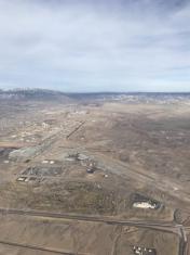
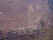
Airport Images
By: Jmckay10
By: Dave


Comments
Charts Not Appearing for KABQ
As of 26 AUG 2016, KABQ only displays 4 non-RNAV STARs while using the primary graphic interface. This has been the case for some time.
All charts are available on the airport data page though.