Login
Register


ABY
Southwest Georgia Regional Airport
Official FAA Data Effective 2024-04-18 0901Z
Chart Supplement

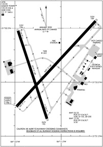
KABY Airport Diagram
VFR Chart of KABY
Sectional Charts at SkyVector.com
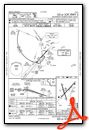
IFR Chart of KABY
Enroute Charts at SkyVector.com
Location Information for KABY
Coordinates: N31°32.13' / W84°11.67'Located 03 miles SW of Albany, Georgia on 980 acres of land. View all Airports in Georgia.
Surveyed Elevation is 196 feet MSL.
Operations Data
|
|
Airport Communications
| ATIS: | 133.05 |
|---|---|
| ASOS: | Tel. 229-434-7494 |
| ALBANY TOWER: | 120.25 336.4 |
| ALBANY GROUND: | 121.9 348.6 |
| UNICOM: | 122.950 |
| CTAF: | 120.250 |
| AWOS-3T at CXU (19.5 S): | 118.675 229-336-0744 |
| AWOS-3PT at MGR (33.7 SE): | 118.925 229-890-5320 |
| AWOS-3 at ACJ (34.5 N): | 128.375 770-847-7993 |
- APCH/DEP SVC PRVDD BY JACKSONVILLE ARTCC ON FREQS 125.75/363.075 (ALBANY RCAG).
Nearby Navigation Aids
|
| ||||||||||||||||||||||||||||||||||||||||||||||||||||||||||||


Runway 05/23
| Dimensions: | 6601 x 148 feet / 2012 x 45 meters | |
|---|---|---|
| Surface: | Asphalt / Grooved in Good Condition | |
| Weight Limits: | 57 /F/A/X/T, S-80, D-135, ST-230 | |
| Edge Lighting: | High Intensity | |
| Runway 05 | Runway 23 | |
| Coordinates: | N31°31.78' / W84°11.98' | N31°32.58' / W84°11.13' |
| Elevation: | 195.7 | 188.9 |
| Traffic Pattern: | Right | Left |
| Runway Heading: | 42° True | 222° True |
| Declared Distances: | TORA:6601 TODA:6601 ASDA:6601 LDA:6601 | TORA:6601 TODA:6601 ASDA:6601 LDA:6601 |
| Markings: | Precision Instrument in good condition. | Precision Instrument in good condition. |
| Glide Slope Indicator | P4L (3.00° Glide Path Angle) PAPI UNUSBL BYD 8 DEGS RIGHT OF CNTRLN. | P4L (3.00° Glide Path Angle) |
| RVR Equipment | Touchdown | Rollout |
| Approach Lights: | MALSR 1,400 Foot Medium-intensity Approach Lighting System with runway alignment indicator lights. | |
| REIL: | Yes | |
| Obstacles: | 79 ft Trees 3175 ft from runway, 550 ft right of center | 67 ft Antenna 2800 ft from runway, 800 ft left of center |
Runway 17/35
| Dimensions: | 5219 x 148 feet / 1591 x 45 meters | |
|---|---|---|
| Surface: | Asphalt / Grooved in Fair Condition | |
| Weight Limits: | 29 /F/A/X/T, S-30 | |
| Edge Lighting: | Medium Intensity | |
| Runway 17 | Runway 35 | |
| Coordinates: | N31°32.48' / W84°11.97' | N31°31.66' / W84°11.65' |
| Elevation: | 194.1 | 195.0 |
| Traffic Pattern: | Right | Left |
| Runway Heading: | 162° True | 342° True |
| Markings: | Non-Precision Instrument in good condition. | Non-Precision Instrument in good condition. |
| Glide Slope Indicator | V4L (3.00° Glide Path Angle) | V4L (3.00° Glide Path Angle) |
| REIL: | Yes | Yes |
| Obstacles: | 42 ft Tree 1200 ft from runway, 400 ft left of center | 54 ft Trees 1700 ft from runway, 482 ft left of center |
Services Available
| Fuel: | 100LL (blue), Jet-A |
|---|---|
| Transient Storage: | Hangars,Tiedowns |
| Airframe Repair: | MINOR |
| Engine Repair: | MINOR |
| Bottled Oxygen: | LOW |
| Bulk Oxygen: | NONE |
| Other Services: | AIR FREIGHT SERVICES,CROP DUSTING SERVICES,AIR AMBULANCE SERVICES,AVIONICS,CARGO HANDLING SERVICES,CHARTER SERVICE,PILOT INSTRUCTION,AIRCRAFT RENTAL,AIRCRAFT SALES |
Ownership Information
| Ownership: | Publicly owned | |
|---|---|---|
| Owner: | CITY OF ALBANY | ARPT OPERATED BY ALBANY-DOUGHERTY CO AVIATION COMMISSION. |
| 3905 NEWTON ROAD, SUITE 100 | ||
| ALBANY, GA 31701-7356 | ||
| 229-302-1500 | ||
| Manager: | MR. DAVID HAMILTON | FBO FREQ 129.8 |
| 3905 NEWTON RD., SUITE 100 | ||
| ALBANY, GA 31701 | ||
| 229-302-1500 | ||
Operational Statistics
| Single Engine Aircraft Based on Field: | 24 | Statistics collected for 12 month period ending 2022-11-30 | |
|---|---|---|---|
| Multi-Engine Aircraft Based on Field: | 7 | Annual Commercial Operations: | 2006 |
| Jet Aircraft Based on Field: | 4 | Annual Commuter Operations: | none |
| Helicopters Based on Field: | 2 | Annual Air Taxi Operations: | 2826 |
| Military Aircraft Based on Field: | none | Annual Military Operations: | 3761 |
| Gliders Based on Field: | none | Annual GA Local Operations: | 2174 |
| Ultralights Based on Field: | none | Annual GA Itinerant Operations: | 7473 |
Other Remarks
- FOR CD IF UNA TO CTC ON FSS FREQ, CTC JACKSONVILLE ARTCC AT 904-845-1592.
- LOW FLYNG ACFT 3 MILES SOUTHEAST.
- ACFT BYD 3 NM AND BLO 2000 FT ON APCH TO RWY 17 BRG 325-040 FROM ARPT NOT VISIBLE FM ATCT DUE TO TREES.
- NUMEROUS BIRDS ON & WITHIN 5 NM OF ARPT SEP-FEB.
- TWY H SOUTH OF CARGO RAMP OTS INDEFLY.
- PERSONNEL AND EQUIPMENT MOWING GRASS ADJACENT TO ALL RUNWAYS AND TAXIWAYS APRIL 1- OCTOBER 30TH.
- ACFT GTR THAN 350000 LBS GWT ARE RSTRD FM USING RWY 5/23 EXC 24HR PPR CALL AMGR 229-302-1500.
- CTAF FREQ 120.25 UNREL FOR GROUND TO GROUND TWO WAY COM USE CAUTION ON CTAF.
- FUEL AVBL AFTER HOURS CALL 229-434-8787.
- WHEN ATCT CLSD, ACTVT MALSR RWY 05; REIL RWY 35; PAPI RWY 23; HIRL RWY 05/23; MIRL RWY 17/35 - CTAF.
Weather Minimums

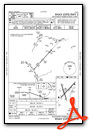
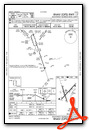
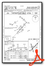
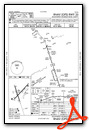
Instrument Approach Procedure (IAP) Charts

Nearby Airports with Instrument Procedures
| ID | Name | Heading / Distance | ||
|---|---|---|---|---|
 |
KCXU | Camilla-Mitchell County Airport | 186° | 19.4 |
|
75J | Turner County Airport | 072° | 30.2 |
|
KMGR | Moultrie Municipal Airport | 143° | 33.6 |
|
KACJ | Jimmy Carter Regional Airport | 000° | 34.4 |
|
KCKF | Crisp County-Cordele Airport | 038° | 34.6 |
|
KTMA | Henry Tift Myers Airport | 099° | 36.7 |
|
KBIJ | Early County Airport | 257° | 36.9 |
|
70J | Cairo-Grady County Airport | 176° | 38.8 |
|
KBGE | Decatur County Industrial Air Park Airport | 214° | 40.7 |
|
KTVI | Thomasville Regional Airport | 156° | 41.2 |
|
15J | Cook County Airport | 121° | 44.9 |
|
53A | Dr C P Savage Sr Airport | 011° | 46.9 |
Airport Images
Do you have a recent image of this airport? Upload it here!


