Login
Register


ACV
California Redwood Coast-Humboldt County Airport
Official FAA Data Effective 2024-04-18 0901Z
Chart Supplement

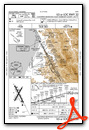
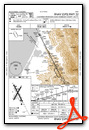
VFR Chart of KACV
Sectional Charts at SkyVector.com
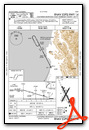
IFR Chart of KACV
Enroute Charts at SkyVector.com
Location Information for KACV
Coordinates: N40°58.67' / W124°6.51'Located 07 miles N of Arcata/Eureka, California on 745 acres of land. View all Airports in California.
Surveyed Elevation is 222 feet MSL.
Operations Data
|
|
Airport Communications
| ASOS: | 118.525 Tel. 707-839-7429 |
|---|---|
| CTAF: | 123.000 |
| UNICOM: | 123.000 |
| AWOS-3 at FOT (25.5 S): | 133.8 707-725-2909 |
| ASOS at CEC (48.7 N): | 119.925 707-465-5458 |
| AWOS-2 at O16 (55.3 S): | 133.0 707-923-4291 |
- APCH/DEP CTL SVC PRVDD BY SEATTLE ARTCC (ZSE) ON FREQS 124.85/306.3 (ARCATA RCAG).
Nearby Navigation Aids
|
| ||||||||||||||||||||||||||||||||||||||||||


Runway 14/32
| Dimensions: | 6046 x 150 feet / 1843 x 46 meters | |
|---|---|---|
| Surface: | Asphalt / Grooved in Good Condition | |
| Weight Limits: | 23 /F/D/X/U, S-60, D-155, ST-280 | |
| Edge Lighting: | High Intensity | |
| Runway 14 | Runway 32 | |
| Coordinates: | N40°59.12' / W124°6.79' | N40°58.23' / W124°6.19' |
| Elevation: | 182.9 | 222.3 |
| Traffic Pattern: | Right | Left |
| Runway Heading: | 153° True | 333° True |
| Displaced Threshold: | 245 Feet | 200 Feet |
| Declared Distances: | TORA:6046 TODA:6046 ASDA:5846 LDA:5601 | TORA:6046 TODA:6046 ASDA:6046 LDA:5846 |
| Markings: | Precision Instrument in good condition. | Precision Instrument in good condition. |
| Glide Slope Indicator | P4L (3.00° Glide Path Angle) | P4L (3.00° Glide Path Angle) |
| RVR Equipment | Touchdown Rollout | Touchdown Rollout |
| Approach Lights: | MALSR 1,400 Foot Medium-intensity Approach Lighting System with runway alignment indicator lights. | |
| REIL: | Yes | |
| Centerline Lights: | Yes | |
| Obstacles: | 91 ft Tree 2625 ft from runway, 875 ft right of center | |
Runway 01/19
| Dimensions: | 4501 x 150 feet / 1372 x 46 meters | |
|---|---|---|
| Surface: | Asphalt / Grooved in Good Condition | |
| Weight Limits: | 5 /F/D/X/U, S-60, D-95, ST-170 | |
| Edge Lighting: | Medium Intensity | |
| Runway 01 | Runway 19 | |
| Coordinates: | N40°58.34' / W124°6.78' | N40°58.99' / W124°6.29' |
| Elevation: | 187.4 | 208.3 |
| Traffic Pattern: | Left | Right |
| Runway Heading: | 30° True | 210° True |
| Declared Distances: | TORA:4501 TODA:4501 ASDA:4501 LDA:4501 | TORA:4501 TODA:4501 ASDA:4501 LDA:4501 |
| Markings: | Non-Precision Instrument in fair condition. | Non-Precision Instrument in fair condition. |
| Glide Slope Indicator | V4L (3.00° Glide Path Angle) | |
| REIL: | Yes | |
| Obstacles: | 142 ft Trees 3450 ft from runway | |
Services Available
| Fuel: | 100LL (blue), Jet-A |
|---|---|
| Transient Storage: | Tiedowns |
| Airframe Repair: | NONE |
| Engine Repair: | NONE |
| Bottled Oxygen: | NONE |
| Bulk Oxygen: | NONE |
| Other Services: | CARGO HANDLING SERVICES |
Ownership Information
| Ownership: | Publicly owned | |
|---|---|---|
| Owner: | HUMBOLDT COUNTY | |
| 1106 SECOND ST | ||
| EUREKA, CA 95501 | ||
| (707) 496-0102 | ||
| Manager: | CODY ROGGATZ | |
| 3561 BOEING AVE. | ||
| MCKINLEYVILLE, CA 95519 | ||
| 707-839-5401 | ||
Operational Statistics
| Single Engine Aircraft Based on Field: | 18 | Statistics collected for 12 month period ending 2019-05-31 | |
|---|---|---|---|
| Multi-Engine Aircraft Based on Field: | 3 | Annual Commercial Operations: | 5840 |
| Jet Aircraft Based on Field: | none | Annual Commuter Operations: | none |
| Helicopters Based on Field: | 3 | Annual Air Taxi Operations: | none |
| Military Aircraft Based on Field: | 3 | Annual Military Operations: | 25750 |
| Gliders Based on Field: | none | Annual GA Local Operations: | 4830 |
| Ultralights Based on Field: | none | Annual GA Itinerant Operations: | 5754 |
Other Remarks
- FOR CD IF UNA TO CTC ON FSS FREQ, CTC SEATTLE ARTCC AT 253-351-3694.
- 0LL FUEL AVBL 0400-2400 LOCAL, AND AFTER HOURS WITH ADVANCED NOTICE.
- ACTVT MALSR RWY 32; TDZL RWY 32; C/L LGTS RWY 32; REIL RWY 14; PAPI RWY 14 & 32; HIRL RWY 14/32 - CTAF. MIRL RWY 01/19, REIL RWY 01, AND VASI RWY 01 PPR CTC 707-382-2551 OR 707-496-0102.
Weather Minimums
Instrument Approach Procedure (IAP) Charts

Departure Procedure (DP) Charts
Nearby Airports with Instrument Procedures
| ID | Name | Heading / Distance | ||
|---|---|---|---|---|
 |
KEKA | Murray Field Airport | 181° | 10.5 |
|
KFOT | Rohnerville Airport | 182° | 25.4 |
|
KCEC | Jack Mc Namara Field Airport | 353° | 48.5 |
|
KBOK | Brookings Airport | 352° | 66.2 |
|
O46 | Weed Airport | 067° | 80.7 |
|
O85 | Benton Field Airport | 106° | 81.2 |
|
KRDD | Redding Regional Airport | 108° | 87.4 |
|
4S1 | Gold Beach Municipal Airport | 350° | 87.4 |
|
3S8 | Grants Pass Airport | 019° | 97.4 |
|
O28 | Ells Field/Willits Municipal Airport | 159° | 97.6 |
|
KRBL | Red Bluff Municipal Airport | 119° | 98.3 |
|
KMFR | Rogue Valley International - Medford Airport | 033° | 100.5 |
Airport Images
Do you have a recent image of this airport? Upload it here!


