Login
Register


ADH
Ada Regional Airport
Official FAA Data Effective 2024-03-21 0901Z
Chart Supplement

VFR Chart of KADH
Sectional Charts at SkyVector.com
IFR Chart of KADH
Enroute Charts at SkyVector.com
Location Information for KADH
Coordinates: N34°48.26' / W96°40.27'Located 02 miles N of Ada, Oklahoma on 770 acres of land. View all Airports in Oklahoma.
Surveyed Elevation is 1015 feet MSL.
Operations Data
|
|
Airport Communications
| AWOS-3: | 118.725 Tel. 580-332-6222 |
|---|---|
| UNICOM: | 122.800 |
| CTAF: | 122.800 |
| AWOS-3 at PVJ (27.8 W): | 118.675 405-238-4452 |
| AWOS-3 at SRE (28.2 N): | 118.625 405-382-0111 |
| AWOS-3 at ADM (34.5 SW): | 125.6 580-389-5078 |
- APCH/DEP CTL SVC PRVDD BY FORT WORTH ARTCC (ZFW) ON FREQS 132.2/338.35 (MC ALESTER RCAG).
Nearby Navigation Aids
|
| ||||||||||||||||||||||||||||||||||||||||||||||||||||||||||||


Runway 18/36
| Dimensions: | 6203 x 100 feet / 1891 x 30 meters | |
|---|---|---|
| Surface: | Asphalt in Fair Condition | |
| Weight Limits: | S-50, D-140, ST-224 | |
| Edge Lighting: | Medium Intensity | |
| Runway 18 | Runway 36 | |
| Coordinates: | N34°48.80' / W96°40.32' | N34°47.77' / W96°40.32' |
| Elevation: | 1015.9 | 979.4 |
| Traffic Pattern: | Left | Left |
| Runway Heading: | 180° True | 360° True |
| Displaced Threshold: | 100 Feet | |
| Markings: | Non-Precision Instrument in good condition. | Non-Precision Instrument in good condition. |
| Glide Slope Indicator | P4L (3.00° Glide Path Angle) | P4L (3.00° Glide Path Angle) UNUSBL BYD 7 DEGS RIGHT OF CNTRLN. |
| Approach Lights: | ODALS Omnidirectional Approach Lighting System | |
| REIL: | Yes | |
| Obstacles: | 31 ft Trees 1039 ft from runway, 54 ft left of center CLNC SLP TO DISP THLD 22:1. |
62 ft Trees 1249 ft from runway, 335 ft left of center |
Runway 13/31
| Dimensions: | 2717 x 50 feet / 828 x 15 meters | |
|---|---|---|
| Surface: | Asphalt-Concrete in Poor Condition SVR CRACKING & RAVELING ASPH PTN. | |
| Weight Limits: | S-50, D-171, ST-280 | |
| Runway 13 | Runway 31 | |
| Coordinates: | N34°48.35' / W96°40.36' | N34°48.03' / W96°39.97' |
| Elevation: | 1004.0 | 978.6 |
| Traffic Pattern: | Left | Left |
| Runway Heading: | 135° True | 315° True |
| Markings: | Basic in poor condition. | Basic in poor condition. |
Helipad H1
| Dimensions: | 40 x 40 feet / 12 x 12 meters | |
|---|---|---|
| Surface: | Concrete in Excellent Condition | |
| Edge Lighting: | Perimeter | |
| Coordinates: | N34°48.22' / W96°40.52' | N0°0.00' / E0°0.00' |
| Elevation: | 1002.0 | |
| Markings: | Non-Standard in good condition. | |
Services Available
| Fuel: | 100LL (blue), Jet A+ |
|---|---|
| Transient Storage: | Hangars,Tiedowns |
| Airframe Repair: | MAJOR |
| Engine Repair: | MAJOR |
| Bottled Oxygen: | NOT AVAILABLE |
| Bulk Oxygen: | HIGH/LOW |
| Other Services: | AIR AMBULANCE SERVICES,AIRCRAFT RENTAL,ANNUAL SURVEYING |
Ownership Information
| Ownership: | Publicly owned | |
|---|---|---|
| Owner: | CITY OF ADA | |
| 231 S TOWNSEND, 512 N. STOCKTON | ||
| ADA, OK 74820 | ||
| 580-436-6300 | ||
| Manager: | CHRIS SOMERS | |
| 300 RAY STOUT BLVD, SUITE A | ||
| ADA, OK 74820 | ||
| 580-436-8190 | ||
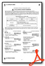
Operational Statistics
| Single Engine Aircraft Based on Field: | 42 | Statistics collected for 12 month period ending 2023-09-22 | |
|---|---|---|---|
| Multi-Engine Aircraft Based on Field: | 5 | Annual Commercial Operations: | none |
| Jet Aircraft Based on Field: | 2 | Annual Commuter Operations: | none |
| Helicopters Based on Field: | 2 | Annual Air Taxi Operations: | none |
| Military Aircraft Based on Field: | none | Annual Military Operations: | 100 |
| Gliders Based on Field: | none | Annual GA Local Operations: | 4100 |
| Ultralights Based on Field: | none | Annual GA Itinerant Operations: | 8200 |
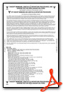
Other Remarks
- FOR CD CTC FORT WORTH ARTCC AT 817-858-7584.
- MARKINGS SVRLY FADED.
- MARKINGS SVRLY FADED.
- 0LL AFT HR FUEL - 580-235-5279.
- ACTVT ODALS RWY 18; REILS RWY 36; MIRL RWY 18/36 - CTAF. PAPI RWY 18 & 36 ON CONSLY.
Weather Minimums
Instrument Approach Procedure (IAP) Charts
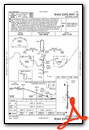
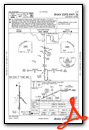
Nearby Airports with Instrument Procedures
| ID | Name | Heading / Distance | ||
|---|---|---|---|---|
 |
F99 | Holdenville Municipal Airport | 036° | 21.0 |
|
KPVJ | Pauls Valley Municipal Airport | 258° | 27.9 |
|
KSRE | Seminole Municipal Airport | 359° | 28.2 |
|
KADM | Ardmore Municipal Airport | 210° | 34.6 |
|
KSNL | Shawnee Regional Airport | 338° | 35.7 |
|
1F4 | Madill Municipal Airport | 190° | 40.4 |
|
O47 | Prague Municipal Airport | 356° | 40.6 |
|
KMLC | Mc Alester Regional Airport | 083° | 44.1 |
|
1K4 | David Jay Perry Airport | 298° | 44.7 |
|
1F0 | Ardmore Downtown Exec Airport | 209° | 45.3 |
|
KOUN | University of Oklahoma Westheimer Airport | 304° | 47.5 |
|
F10 | Henryetta Municipal Airport | 041° | 48.4 |
Airport Images
Do you have a recent image of this airport? Upload it here!


