Login
Register


AGO
Ralph C Weiser Field Airport
Official FAA Data Effective 2024-04-18 0901Z
Chart Supplement

VFR Chart of KAGO
Sectional Charts at SkyVector.com
IFR Chart of KAGO
Enroute Charts at SkyVector.com
Location Information for KAGO
Coordinates: N33°13.65' / W93°13.02'Located 03 miles SE of Magnolia, Arkansas on 272 acres of land. View all Airports in Arkansas.
Surveyed Elevation is 319 feet MSL.
Operations Data
|
|
Airport Communications
| AWOS-3: | 118.05 Tel. 870-901-3532 |
|---|---|
| CTAF: | 122.800 |
| UNICOM: | 122.800 |
| ASOS at ELD (20.3 E): | 118.325 870-862-3090 |
| AWOS-3 at CDH (32.9 NE): | 125.2 870-574-1011 |
| AWOS-3PT at MNE (35.3 S): | 119.325 318-371-7874 |
- APCH/DEP CTL SVC PRVDD BY FORT WORTH ARTCC (ZFW) ON FREQS 128.2/269.1 (EL DORADO RCAG).
Nearby Navigation Aids
|
| ||||||||||||||||||||||||||||||||||||||||||||||||||||||||||||


Runway 18/36
| Dimensions: | 5007 x 100 feet / 1526 x 30 meters | |
|---|---|---|
| Surface: | Asphalt in Fair Condition | |
| Weight Limits: | S-50, D-75, ST-130 | |
| Edge Lighting: | Medium Intensity | |
| Runway 18 | Runway 36 | |
| Coordinates: | N33°14.06' / W93°13.00' | N33°13.24' / W93°13.03' |
| Elevation: | 300.9 | 319.4 |
| Traffic Pattern: | Left | Left |
| Runway Heading: | 182° True | 2° True |
| Markings: | Non-Precision Instrument in fair condition. | Non-Precision Instrument in fair condition. |
| Glide Slope Indicator | P2L (3.00° Glide Path Angle) | P2L (4.00° Glide Path Angle) |
| REIL: | Yes | Yes |
| Obstacles: | 45 ft Trees 2100 ft from runway | |
Services Available
| Fuel: | 100LL (blue), Jet-A |
|---|---|
| Transient Storage: | Hangars,Tiedowns |
| Airframe Repair: | NOT AVAILABLE |
| Engine Repair: | NOT AVAILABLE |
| Bottled Oxygen: | NONE |
| Bulk Oxygen: | NONE |
| Other Services: | CROP DUSTING SERVICES,PILOT INSTRUCTION |
Ownership Information
| Ownership: | Publicly owned | |
|---|---|---|
| Owner: | CITY OF MAGNOLIA | |
| CITY HALL, P.O. BOX 1126 | ||
| MAGNOLIA, AR 71754 | ||
| 870-234-1375 | ||
| Manager: | BRAD HAM | |
| 212 AIRPORT 980 | ||
| MAGNOLIA, AR 71753 | ||
| (870) 904-6731 | ||
Operational Statistics
| Single Engine Aircraft Based on Field: | 11 | Statistics collected for 12 month period ending 2022-02-28 | |
|---|---|---|---|
| Multi-Engine Aircraft Based on Field: | 1 | Annual Commercial Operations: | none |
| Jet Aircraft Based on Field: | none | Annual Commuter Operations: | none |
| Helicopters Based on Field: | none | Annual Air Taxi Operations: | none |
| Military Aircraft Based on Field: | none | Annual Military Operations: | 100 |
| Gliders Based on Field: | none | Annual GA Local Operations: | 3000 |
| Ultralights Based on Field: | none | Annual GA Itinerant Operations: | 2500 |
Other Remarks
- FOR CD CTC FORT WORTH ARTCC AT 817-858-7584.
- 0LL SELF SERVE FUEL AVBL 24 HRS WITH CREDIT CARD. FOR SVC AFT HRS CALL 870-904-6731
- PAPI RWYS 18 & 36 ON 24/7. ACTVT REIL & MIRL RWY 18/36 CTAF.
Weather Minimums

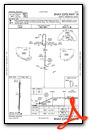
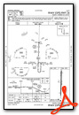
Instrument Approach Procedure (IAP) Charts
Nearby Airports with Instrument Procedures
| ID | Name | Heading / Distance | ||
|---|---|---|---|---|
 |
KSPH | Springhill Airport | 213° | 17.5 |
|
KELD | South Arkansas Regional At Goodwin Field Airport | 090° | 20.4 |
|
KCDH | Harrell Field Airport | 043° | 32.9 |
|
KMNE | Minden Airport | 186° | 35.1 |
|
M18 | Hope Municipal Airport | 323° | 36.9 |
|
KTXK | Texarkana Regional-Webb Field Airport | 289° | 41.2 |
|
3F4 | Vivian Airport | 241° | 45.6 |
|
KBAD | Barksdale AFB Airport | 207° | 48.9 |
|
KDTN | Shreveport Downtown Airport | 213° | 49.0 |
|
KATA | Hall-Miller Municipal Airport | 261° | 49.8 |
|
KADF | Dexter B Florence Memorial Field Airport | 008° | 52.8 |
|
KRSN | Ruston Regional Airport | 143° | 53.3 |
Airport Images
Do you have a recent image of this airport? Upload it here!


