Login
Register


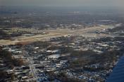
ALB
Albany International Airport
Official FAA Data Effective 2024-04-18 0901Z
Chart Supplement

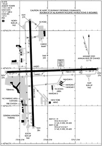
KALB Airport Diagram
VFR Chart of KALB
Sectional Charts at SkyVector.com
IFR Chart of KALB
Enroute Charts at SkyVector.com
Location Information for KALB
Coordinates: N42°44.95' / W73°48.12'Located 06 miles NW of Albany, New York on 1000 acres of land. View all Airports in New York.
Surveyed Elevation is 284 feet MSL.
Operations Data
|
|
Airport Communications
| D-ATIS: | 120.45 |
|---|---|
| ASOS: | 120.45 Tel. 518-464-6423 |
| ALBANY TOWER: | 119.5 257.8 |
| ALBANY GROUND: | 121.7 348.6 |
| ALBANY APPROACH: | 118.05 ;194-011 118.05 127.15 132.825 ;011-194 263.075 ;194-011 307.2 ;011-194 |
| ALBANY DEPARTURE: | 118.05 ;194-011 118.05 127.15 132.825 ;011-194 263.075 ;194-011 307.2 ;011-194 |
| IC: | 132.825 ;011-194 307.2 ;011-194 |
| CLEARANCE DELIVERY: | 127.5 |
| UNICOM: | 122.950 |
| NG OPS: | 122.775 258.2 30.1FM |
| EMERG: | 121.5 243.0 |
| CLASS C: | 118.05 ;194-011 132.825 ;011-194 263.075 ;194-011 307.2 ;011-194 |
| AWOS-3 at SCH (8.3 NW): | 119.275 518-399-6586 |
| AWOS-3 at 5B2 (18.1 N): | 132.025 518-884-9289 |
| ASOS at DDH (25.9 E): | 135.925 802-442-6059 |
Nearby Navigation Aids
|
| ||||||||||||||||||||||||||||||||||||||||||||||||||||||||||||


Runway 01/19
| Dimensions: | 8500 x 150 feet / 2591 x 46 meters | |
|---|---|---|
| Surface: | Asphalt / Grooved in Good Condition | |
| Weight Limits: | 70 /F/C/X/T, S-140, D-200, ST-400 | |
| Edge Lighting: | High Intensity | |
| Runway 01 | Runway 19 | |
| Coordinates: | N42°44.23' / W73°48.26' | N42°45.63' / W73°48.32' |
| Elevation: | 284.3 | 279.4 |
| Traffic Pattern: | Left | Left |
| Runway Heading: | 358° True | 178° True |
| Declared Distances: | TORA:8500 TODA:8500 ASDA:8500 LDA:8500 | TORA:8500 TODA:8500 ASDA:8500 LDA:8500 |
| Markings: | Precision Instrument in good condition. | Precision Instrument in good condition. |
| Glide Slope Indicator | P4R (3.00° Glide Path Angle) | P4L (3.00° Glide Path Angle) |
| RVR Equipment | Touchdown Rollout | Touchdown Rollout |
| Approach Lights: | MALSR 1,400 Foot Medium-intensity Approach Lighting System with runway alignment indicator lights. | MALSR 1,400 Foot Medium-intensity Approach Lighting System with runway alignment indicator lights. |
| Centerline Lights: | Yes | Yes |
| Obstacles: | 80 ft Tree 2040 ft from runway, 75 ft left of center | |
Runway 10/28
| Dimensions: | 7200 x 150 feet / 2195 x 46 meters | |
|---|---|---|
| Surface: | Asphalt / Grooved in Good Condition | |
| Weight Limits: | 67 /F/C/X/T, S-140, D-200, ST-400 | |
| Edge Lighting: | Medium Intensity | |
| Runway 10 | Runway 28 | |
| Coordinates: | N42°44.95' / W73°48.73' | N42°44.99' / W73°47.12' |
| Elevation: | 276.4 | 276.0 |
| Traffic Pattern: | Left | Left |
| Runway Heading: | 88° True | 268° True |
| Displaced Threshold: | 1192 Feet | |
| Declared Distances: | TORA:7200 TODA:7200 ASDA:6780 LDA:6780 | TORA:7200 TODA:7200 ASDA:7200 LDA:6007 |
| Markings: | Non-Precision Instrument in good condition. | Non-Precision Instrument in good condition. |
| Glide Slope Indicator | P4L (3.22° Glide Path Angle) | |
| REIL: | Yes | Yes |
| Centerline Lights: | Yes | Yes |
| Obstacles: | 151 ft Ground 5009 ft from runway, 84 ft left of center A 057 RWY 28 APCH RATIO 26:1 TO DTHR. |
54 ft Tree 1019 ft from runway, 162 ft left of center |
Services Available
| Fuel: | 100LL (blue), Jet-A |
|---|---|
| Transient Storage: | Hangars,Tiedowns |
| Airframe Repair: | MAJOR |
| Engine Repair: | MAJOR |
| Bottled Oxygen: | HIGH |
| Bulk Oxygen: | NOT AVAILABLE |
| Other Services: | CARGO HANDLING SERVICES,PILOT INSTRUCTION,AIRCRAFT RENTAL,AIRCRAFT SALES,ANNUAL SURVEYING |
Ownership Information
| Ownership: | Publicly owned | |
|---|---|---|
| Owner: | ALBANY COUNTY ARPT AUTH | LEASEE. PROPERTY OWNED BY ALBANY COUNTY, 112 STATE ST., ALBANY, NY 12207; TELEPHONE 518-447-7000. |
| 737 ALBANY SHAKER ROAD | ||
| ALBANY, NY 12211 | ||
| 518-242-2200 | ||
| Manager: | TODD PENNINGTON | |
| 737 ALBANY SHAKER ROAD | ||
| ALBANY, NY 12211 | ||
| 518-242-2352 | ||
Operational Statistics
| Single Engine Aircraft Based on Field: | 57 | Statistics collected for 12 month period ending 2023-01-01 | |
|---|---|---|---|
| Multi-Engine Aircraft Based on Field: | 7 | Annual Commercial Operations: | 26287 |
| Jet Aircraft Based on Field: | 5 | Annual Commuter Operations: | none |
| Helicopters Based on Field: | 11 | Annual Air Taxi Operations: | 10619 |
| Military Aircraft Based on Field: | 11 | Annual Military Operations: | 2463 |
| Gliders Based on Field: | none | Annual GA Local Operations: | 8009 |
| Ultralights Based on Field: | none | Annual GA Itinerant Operations: | 6421 |
Other Remarks
- MOWING W/I SAFETY AREAS OF ALL RYS & TWYS MAY THRU NOV.
- NO ACFT PARKING BETWEEN FIRE STATION AND TWY L.
- TWY D EAST OF RY 01/19 IS RESTRD TO ACFT 12500 LBS & LESS.
- BIRDS, DEER & OTHER WILDLIFE ON & INVOF ARPT.
- WEATHER BALLOON LAUNCHES APRXLY 3 MI SOUTH OF ARPT AT 0600 & 1800.
- TWY 'C' W OF TWY 'A' NON MOVEMENT AREA.
- CUSTOMS/IMMIGRATION FLIGHT INFO SERVICE FACILITY LCTD NORTH END GENERAL AVIATION APRON. ACFT CLEARING CUSTOMS UTILIZE PAINTED POSITION MKGS & PROCEED TO MINIMIZE BLAST IMPACT.
Weather Minimums
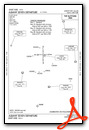
Instrument Approach Procedure (IAP) Charts
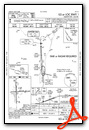
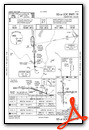
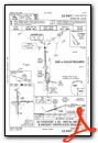
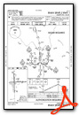
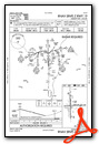
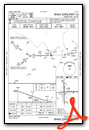
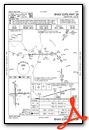
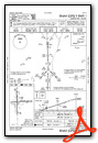
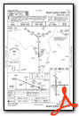
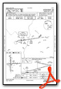
Departure Procedure (DP) Charts
Nearby Airports with Instrument Procedures
| ID | Name | Heading / Distance | ||
|---|---|---|---|---|
 |
KSCH | Schenectady County Airport | 317° | 8.4 |
|
4B0 | South Albany Airport | 187° | 11.4 |
|
5B2 | Saratoga County Airport | 351° | 18.3 |
|
KDDH | William H Morse State Airport | 070° | 26.0 |
|
NY0 | Fulton County Airport | 302° | 27.7 |
|
1B1 | Columbia County Airport | 171° | 27.8 |
|
KAQW | Harriman-and-West Airport | 096° | 28.1 |
|
KPSF | Pittsfield Municipal Airport | 130° | 29.8 |
|
KGFL | Floyd Bennett Memorial Airport | 013° | 36.5 |
|
KGBR | Walter J Koladza Airport | 152° | 38.2 |
|
20N | Kingston-Ulster Airport | 189° | 46.4 |
|
K09 | Piseco Airport | 323° | 52.6 |