Login
Register


AMW
Ames Municipal Airport
Official FAA Data Effective 2024-03-21 0901Z
Chart Supplement

VFR Chart of KAMW
Sectional Charts at SkyVector.com
IFR Chart of KAMW
Enroute Charts at SkyVector.com
Location Information for KAMW
Coordinates: N41°59.52' / W93°37.31'Located 02 miles SE of Ames, Iowa on 700 acres of land. View all Airports in Iowa.
Surveyed Elevation is 955 feet MSL.
Operations Data
|
|
Airport Communications
| ASOS: | 132.025 Tel. 515-233-2611 |
|---|---|
| DES MOINES APPROACH: | 123.9 307.15 |
| DES MOINES DEPARTURE: | 123.9 307.15 |
| CLEARANCE DELIVERY: | 126.0 |
| UNICOM: | 122.700 |
| CTAF: | 122.700 |
| AWOS-3 at BNW (10.6 W): | 120.925 515-432-9042 |
| AWOS-3 at IKV (18.4 S): | 119.175 515-965-5764 |
| AWOS-3 at PRO (26.0 W): | 118.0 515-465-2269 |
Nearby Navigation Aids
|
| ||||||||||||||||||||||||||||||||||||||||||||||||


Runway 01/19
| Dimensions: | 5701 x 100 feet / 1738 x 30 meters | |
|---|---|---|
| Surface: | Asphalt in Fair Condition | |
| Weight Limits: | 32 /R/C/W/U, S-30, D-38 | |
| Edge Lighting: | High Intensity | |
| Runway 01 | Runway 19 | |
| Coordinates: | N41°58.96' / W93°37.49' | N41°59.86' / W93°37.13' |
| Elevation: | 955.6 | 919.0 |
| Traffic Pattern: | Right | |
| Runway Heading: | 17° True | 197° True |
| Markings: | Precision Instrument in good condition. | Non-Precision Instrument in good condition. |
| Glide Slope Indicator | V4L (4.00° Glide Path Angle) | |
| Approach Lights: | MALSR 1,400 Foot Medium-intensity Approach Lighting System with runway alignment indicator lights. | |
| Obstacles: | 78 ft Tree 2380 ft from runway, 350 ft left of center | 87 ft Tree 2400 ft from runway, 345 ft left of center |
Runway 13/31
| Dimensions: | 3491 x 75 feet / 1064 x 23 meters | |
|---|---|---|
| Surface: | Concrete in Fair Condition | |
| Weight Limits: | 10 /R/D/W/U, S-30 | |
| Edge Lighting: | Medium Intensity | |
| Runway 13 | Runway 31 | |
| Coordinates: | N41°59.91' / W93°37.58' | N41°59.50' / W93°37.05' |
| Elevation: | 925.9 | 920.2 |
| Traffic Pattern: | Right | Left |
| Runway Heading: | 136° True | 316° True |
| Markings: | Non-Precision Instrument in good condition. | Non-Precision Instrument in good condition. |
| Glide Slope Indicator | V4L (3.00° Glide Path Angle) | V4L (3.00° Glide Path Angle) |
| Obstacles: | 16 ft Tree 320 ft from runway, 164 ft left of center 32 FT TREE 124 FT FM RWY END AND 158 FT R ON APCH; CLNC SLOPE 1:1 |
50 ft Tree 1011 ft from runway, 70 ft right of center |
Services Available
| Fuel: | 100 (green), Jet-A |
|---|---|
| Transient Storage: | Hangars,Tiedowns |
| Airframe Repair: | MAJOR |
| Engine Repair: | MAJOR |
| Bottled Oxygen: | NONE |
| Bulk Oxygen: | NOT AVAILABLE |
| Other Services: | CHARTER SERVICE,PILOT INSTRUCTION,AIRCRAFT RENTAL,AIRCRAFT SALES |
Ownership Information
| Ownership: | Publicly owned | |
|---|---|---|
| Owner: | CITY OF AMES | |
| 515 CLARK AVE | ||
| AMES, IA 50010 | ||
| 515-239-5160 | ||
| Manager: | DAMION PREGITZER | |
| 515 CLARK AVE | ||
| AMES, IA 50010 | ||
| 515-239-5275 | ||
Operational Statistics
| Single Engine Aircraft Based on Field: | 47 | Statistics collected for 12 month period ending 2022-09-12 | |
|---|---|---|---|
| Multi-Engine Aircraft Based on Field: | 6 | Annual Commercial Operations: | none |
| Jet Aircraft Based on Field: | 4 | Annual Commuter Operations: | none |
| Helicopters Based on Field: | 1 | Annual Air Taxi Operations: | 1479 |
| Military Aircraft Based on Field: | none | Annual Military Operations: | 446 |
| Gliders Based on Field: | 5 | Annual GA Local Operations: | 11291 |
| Ultralights Based on Field: | none | Annual GA Itinerant Operations: | 16934 |
Other Remarks
- BE ALERT FOR GLIDER & ULTRALIGHT OPNS INVOF ARPT.
- BIRD AND DEER ACT ON & INVOF ARPT
- RWY 01 IS CALM WIND RWY.
- STADIUM WI 3 NM, CHECK FOR EVENTS.
- COLD TEMPERATURE AIRPORT. ALTITUDE CORRECTION REQUIRED AT OR BELOW -27C.
- FOR CD CTC DES MOINES ATCT ON 126.0 OR CALL 515-974- 8016.
- ACTVT MALSR RWY 01; VASI RWYS 13, 19 & 31; HIRL RWY 01/19 & MIRL RWY 13/31 - CTAF.
Weather Minimums
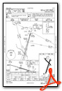
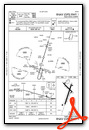
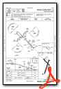
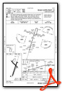
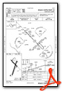
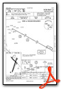
Instrument Approach Procedure (IAP) Charts
Nearby Airports with Instrument Procedures
| ID | Name | Heading / Distance | ||
|---|---|---|---|---|
 |
KBNW | Boone Municipal Airport | 288° | 10.7 |
|
KIKV | Ankeny Regional Airport | 172° | 18.2 |
|
KPRO | Perry Municipal Airport | 247° | 26.0 |
|
KDSM | Des Moines International Airport | 183° | 27.5 |
|
KEBS | Webster City Municipal Airport | 337° | 28.8 |
|
KEFW | Jefferson Municipal Airport | 272° | 32.2 |
|
KMIW | Marshalltown Municipal Airport | 076° | 32.3 |
|
KIFA | Iowa Falls Municipal Airport | 028° | 32.7 |
|
KTNU | Newton Municipal-Earl Johnson Field Airport | 125° | 33.0 |
|
KGCT | Guthrie County Regional Airport | 243° | 40.8 |
|
3Y3 | Winterset Municipal Airport | 205° | 41.8 |
|
KFOD | Fort Dodge Regional Airport | 323° | 42.1 |
Airport Images
Do you have a recent image of this airport? Upload it here!


