Login
Register


ANW
Ainsworth Regional Airport
Official FAA Data Effective 2024-03-21 0901Z
Chart Supplement

VFR Chart of KANW
Sectional Charts at SkyVector.com
IFR Chart of KANW
Enroute Charts at SkyVector.com
Location Information for KANW
Coordinates: N42°34.75' / W99°59.58'Located 06 miles NW of Ainsworth, Nebraska on 2493 acres of land. View all Airports in Nebraska.
Surveyed Elevation is 2588 feet MSL.
Operations Data
|
|
Airport Communications
| AWOS-3: | 118.325 Tel. 402-387-2329 |
|---|---|
| UNICOM: | 122.800 |
| CTAF: | 122.800 |
| ASOS at VTN (29.6 NW): | 118.075 402-376-1673 |
| AWOS-3 at TIF (45.0 SW): | 120.825 308-645-0488 |
| ASOS at ICR (49.1 N): | 126.775 605-842-3989 |
- APCH/DEP CTL SVC PRVDD BY DENVER ARTCC (ZDV) ON FREQ 127.95/338.2 (AINSWORTH RCAG).
Nearby Navigation Aids
|
| ||||||||||||||||||||||||||||||||||||||||||||||||


Runway 17/35
| Dimensions: | 6824 x 110 feet / 2080 x 34 meters | |
|---|---|---|
| Surface: | Asphalt in Good Condition | |
| Weight Limits: | S-30, D-45 | |
| Edge Lighting: | High Intensity | |
| Runway 17 | Runway 35 | |
| Coordinates: | N42°35.17' / W99°59.80' | N42°34.05' / W99°59.78' |
| Elevation: | 2586.5 | 2588.4 |
| Traffic Pattern: | Left | Left |
| Runway Heading: | 179° True | 359° True |
| Markings: | Precision Instrument in good condition. | Precision Instrument in good condition. |
| Glide Slope Indicator | P4L (3.00° Glide Path Angle) | P4L (3.00° Glide Path Angle) |
| Approach Lights: | MALSR 1,400 Foot Medium-intensity Approach Lighting System with runway alignment indicator lights. | MALSR 1,400 Foot Medium-intensity Approach Lighting System with runway alignment indicator lights. |
| Obstacles: | 5 ft Berm 347 ft from runway, 522 ft right of center BERM IS ACTUALLY 4.5 FT; WHICH GIVES THE 32:1 OBSTN CLNC SLOPE. |
48 ft Trees 2259 ft from runway, 306 ft right of center |
Runway 13/31
| Dimensions: | 5501 x 75 feet / 1677 x 23 meters | |
|---|---|---|
| Surface: | Asphalt in Good Condition | |
| Weight Limits: | S-24, D-36 | |
| Edge Lighting: | High Intensity | |
| Runway 13 | Runway 31 | |
| Coordinates: | N42°35.25' / W99°59.75' | N42°34.62' / W99°58.88' |
| Elevation: | 2586.7 | 2582.6 |
| Traffic Pattern: | Left | Left |
| Runway Heading: | 134° True | 314° True |
| Markings: | Non-Precision Instrument in good condition. | Non-Precision Instrument in fair condition. |
| Glide Slope Indicator | P2L (3.00° Glide Path Angle) | P2L (3.00° Glide Path Angle) |
| REIL: | Yes | |
Helipad H1
| Dimensions: | 50 x 50 feet / 15 x 15 meters | |
|---|---|---|
| Surface: | Asphalt in Good Condition | |
| Coordinates: | N42°34.61' / W100°0.02' | N0°0.00' / E0°0.00' |
| Elevation: | 2582.0 | |
Services Available
| Fuel: | 100LL (blue), Jet-A |
|---|---|
| Transient Storage: | Hangars,Tiedowns |
| Airframe Repair: | NONE |
| Engine Repair: | NONE |
| Bottled Oxygen: | NONE |
| Bulk Oxygen: | NONE |
Ownership Information
| Ownership: | Publicly owned | |
|---|---|---|
| Owner: | AINSWORTH ARPT AUTH | |
| PO BOX 84 | ||
| AINSWORTH, NE 69210-0084 | ||
| 402-387-1491 | ARPT MGR. | |
| Manager: | LANCE SCHIPPOREIT | |
| PO BOX 84 | ||
| AINSWORTH, NE 69210-0084 | ||
| 402-387-1491 | AMGR HOME PHONE 402-387-1255/1-800-303-1491. ON CALL. | |
Operational Statistics
| Single Engine Aircraft Based on Field: | 10 | Statistics collected for 12 month period ending 2023-08-07 | |
|---|---|---|---|
| Multi-Engine Aircraft Based on Field: | 1 | Annual Commercial Operations: | none |
| Jet Aircraft Based on Field: | 1 | Annual Commuter Operations: | none |
| Helicopters Based on Field: | 1 | Annual Air Taxi Operations: | none |
| Military Aircraft Based on Field: | none | Annual Military Operations: | 50 |
| Gliders Based on Field: | none | Annual GA Local Operations: | 1300 |
| Ultralights Based on Field: | none | Annual GA Itinerant Operations: | 2650 |
Other Remarks
- HELIPAD FOR REFUELING ONLY. NOT AVBL FOR INST APCHS.
- SEASONAL MIGRATORY WATERFOWL ON & INVOF ARPT.
- FOR CD CTC DENVER ARTCC ON FREQ. IF UNA, CTC FSS ON FREQ VIA RCO. IF UNA, CTC DENVER ARTCC AT 303-651-4257.
- 0LL 24 HR SELF SVC FUEL AVBL VIA CREDIT CARD SYSTEM.
- ACTVT MALSR RWY 17 & 35; REIL RWY 31; PAPI RWY 13 & 31, 17 & 35 & HIRL 13/31 & RWY 17/35 - CTAF.
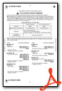
Weather Minimums
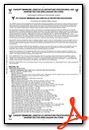
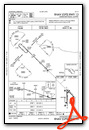
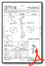
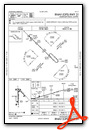
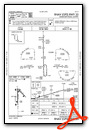
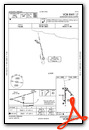
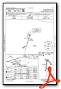
Instrument Approach Procedure (IAP) Charts
Nearby Airports with Instrument Procedures
| ID | Name | Heading / Distance | ||
|---|---|---|---|---|
 |
KRBE | Rock County Airport | 091° | 18.8 |
|
KVTN | Miller Field Airport | 304° | 29.7 |
|
8V2 | Stuart-Atkinson Municipal Airport | 091° | 42.3 |
|
KTIF | Thomas County Airport | 215° | 45.0 |
|
9D1 | Gregory Municipal - Flynn Field Airport | 033° | 46.5 |
|
KICR | Winner Regional Airport | 007° | 49.1 |
|
KSUO | Rosebud Sioux Tribal Airport | 317° | 55.9 |
|
KONL | The O'Neill Municipal-John L Baker Field Airport | 096° | 58.3 |
|
KBUB | Cram Field Airport | 141° | 61.0 |
|
KBBW | Broken Bow Municipal/Keith Glaze Field Airport | 166° | 70.3 |
|
KODX | Evelyn Sharp Field Airport | 140° | 73.8 |
|
9V9 | Chamberlain Municipal Airport | 022° | 77.1 |
Airport Images
Do you have a recent image of this airport? Upload it here!


