Login
Register


APC
Napa County Airport
Official FAA Data Effective 2024-04-18 0901Z
From the Flight Deck
Chart Supplement

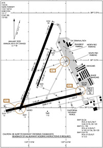
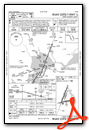
KAPC Airport Diagram
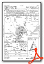
VFR Chart of KAPC
Sectional Charts at SkyVector.com
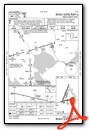
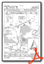
IFR Chart of KAPC
Enroute Charts at SkyVector.com
Location Information for KAPC
Coordinates: N38°12.79' / W122°16.84'Located 05 miles S of Napa, California on 820 acres of land. View all Airports in California.
Surveyed Elevation is 35 feet MSL.
Operations Data
|
|
Airport Communications
| ATIS: | 124.05 ((707) 255-2847) |
|---|---|
| ASOS: | Tel. 707-252-7916 |
| NAPA TOWER: | 118.7 257.8 |
| NAPA GROUND: | 121.7 |
| CLEARANCE DELIVERY: | 127.85 |
| UNICOM: | 122.950 |
| CTAF: | 118.700 |
| EMERG: | 121.5 |
| AWOS-3P at DVO (13.6 W): | 120.675 415-897-2236 |
| AWOS-3P at O69 (15.6 W): | 132.325 707-773-1529 |
| ATIS at CCR (17.1 SE): | 124.7 |
- APCH/DEP SVC PRVDD BY OAKLAND ARTCC (ZOA) ON FREQ 127.8/353.5 (MOUNT TAMALPAIS RCAG).
Nearby Navigation Aids
|
| ||||||||||||||||||||||||||||||||||||


Runway 01L/19R
| Dimensions: | 5930 x 150 feet / 1807 x 46 meters | |
|---|---|---|
| Surface: | Asphalt / Grooved in Good Condition | |
| Weight Limits: | 41 /F/D/X/T, S-102, D-134, ST-120 | |
| Edge Lighting: | Medium Intensity | |
| Runway 01L | Runway 19R | |
| Coordinates: | N38°12.48' / W122°17.12' | N38°13.39' / W122°16.68' |
| Elevation: | 14.5 | 29.7 |
| Traffic Pattern: | Left | Right |
| Runway Heading: | 21° True | 201° True |
| Markings: | Precision Instrument in good condition. | Non-Precision Instrument in good condition. |
| Glide Slope Indicator | P4L (3.25° Glide Path Angle) | |
| Approach Lights: | MALS 1,400 Foot Medium-intensity Approach Lighting System. | |
Runway 06/24
| Dimensions: | 5008 x 150 feet / 1526 x 46 meters | |
|---|---|---|
| Surface: | Concrete in Fair Condition | |
| Weight Limits: | 21 /R/C/W/T, S-60, D-76, ST-120 | |
| Edge Lighting: | Medium Intensity | |
| Runway 06 | Runway 24 | |
| Coordinates: | N38°12.46' / W122°17.31' | N38°12.65' / W122°16.29' |
| Elevation: | 14.5 | 35.5 |
| Traffic Pattern: | Left | Left |
| Runway Heading: | 77° True | 257° True |
| Markings: | Non-Precision Instrument in good condition. | Non-Precision Instrument in good condition. |
| REIL: | Yes | |
Runway 01R/19L
| Dimensions: | 2510 x 75 feet / 765 x 23 meters | |
|---|---|---|
| Surface: | Asphalt in Good Condition | |
| Weight Limits: | 5 /F/D/X/T, S-13 | |
| Runway 01R | Runway 19L | |
| Coordinates: | N38°12.72' / W122°16.88' | N38°13.11' / W122°16.70' |
| Elevation: | 12.5 | 21.4 |
| Traffic Pattern: | Right | Left |
| Runway Heading: | 21° True | 201° True |
| Markings: | Basic in good condition. | Basic in good condition. |
Services Available
| Fuel: | 100LL (blue), Jet-A |
|---|---|
| Transient Storage: | Tiedowns |
| Airframe Repair: | MAJOR |
| Engine Repair: | MAJOR |
| Bottled Oxygen: | HIGH/LOW |
| Bulk Oxygen: | NONE |
| Other Services: | CHARTER SERVICE,PILOT INSTRUCTION,AIRCRAFT RENTAL,AIRCRAFT SALES |
Ownership Information
| Ownership: | Publicly owned | |
|---|---|---|
| Owner: | NAPA COUNTY | |
| 2000 AIRPORT RD. | ||
| NAPA, CA 94558 | ||
| 707-253-4300 | ||
| Manager: | MARK WITSOE | |
| 2000 AIRPORT RD. | ||
| NAPA, CA 94558 | ||
| 707-253-4300 | ||
Operational Statistics
| Single Engine Aircraft Based on Field: | 139 | Statistics collected for 12 month period ending 2020-12-31 | |
|---|---|---|---|
| Multi-Engine Aircraft Based on Field: | 8 | Annual Commercial Operations: | 3 |
| Jet Aircraft Based on Field: | 12 | Annual Commuter Operations: | none |
| Helicopters Based on Field: | 9 | Annual Air Taxi Operations: | 6147 |
| Military Aircraft Based on Field: | none | Annual Military Operations: | 1025 |
| Gliders Based on Field: | none | Annual GA Local Operations: | 18337 |
| Ultralights Based on Field: | none | Annual GA Itinerant Operations: | 19496 |
Other Remarks
- ASPH TWYS STRENGTH 30,000 GWT SINGLE WHEEL.
- ASPH APRONS STRENGTH 12500-30000 LBS GWT SINGLE WHEEL.
- UNLGTD BRIDGE 1 NM S, 167 FT AGL
- DUE TO AIRPORT PROXIMITY TO WETLANDS BIRDS ON AND INVOF THE AIRPORT YEAR AROUND WITH HIGHEST CONCENTRATION OF ACTIVITY OF BIRDS ON THE RYS DURING RAINY WEATHER.
- FOR CD WHEN ATCT CLSD CTC OAKLAND ARTCC AT 510-745-3380.
- 0LL FOR FUEL SVC 2100-0600 CALL 707-224-0887.
- WHEN ATCT CLSD ACTVT MALS RWY 01L; REIL RWY 06; MIRL RWYS 01L/19R & RWY 06/24 - CTAF. PAPI RWY 19R OPR CONSLY.
Weather Minimums
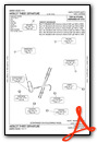
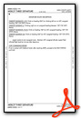
Instrument Approach Procedure (IAP) Charts

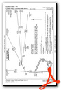
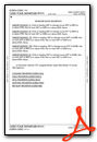
Departure Procedure (DP) Charts
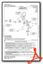
Departure Procedure Obstacles (DPO) Charts
Nearby Airports with Instrument Procedures
| ID | Name | Heading / Distance | ||
|---|---|---|---|---|
 |
KDVO | Gnoss Field Airport | 252° | 13.7 |
|
O69 | Petaluma Municipal Airport | 279° | 15.6 |
|
KCCR | Buchanan Field Airport | 141° | 17.1 |
|
KSUU | Travis AFB Airport | 079° | 17.1 |
|
KVCB | Nut Tree Airport | 056° | 18.0 |
|
O88 | Rio Vista Municipal Airport | 092° | 27.3 |
|
KOAK | Metro Oakland International Airport | 174° | 29.6 |
|
KDWA | Yolo County Airport | 042° | 29.7 |
|
KEDU | University Airport | 050° | 30.1 |
|
KSTS | Charles M Schulz - Sonoma County Airport | 305° | 30.8 |
|
O41 | Watts-Woodland Airport | 034° | 33.7 |
|
KHWD | Hayward Exec Airport | 167° | 34.1 |
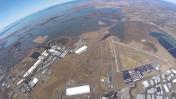
Airport Images

By: gyrosteve
By: bbt95762


