Login
Register


AQW
Harriman-and-West Airport
Official FAA Data Effective 2024-04-18 0901Z
Chart Supplement

VFR Chart of KAQW
Sectional Charts at SkyVector.com
IFR Chart of KAQW
Enroute Charts at SkyVector.com
Location Information for KAQW
Coordinates: N42°41.78' / W73°10.23'Located 03 miles W of North Adams, Massachusetts on 130 acres of land. View all Airports in Massachusetts.
Surveyed Elevation is 653 feet MSL.
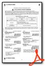
Operations Data
|
|
Airport Communications
| ASOS: | 134.775 Tel. 413-664-6658 |
|---|---|
| ALBANY APPROACH: | 132.825 307.2 |
| ALBANY DEPARTURE: | 132.825 307.2 |
| CTAF: | 122.800 |
| UNICOM: | 122.800 |
| ASOS at DDH (12.2 N): | 135.925 802-442-6059 |
| ASOS at PSF (17.0 S): | 135.375 413-499-3273 |
| ASOS at ALB (28.0 W): | 120.45 518-464-6423 |
- APCH/DEP SVC PRVDD BY ALBANY (ALB) APCH CTL 132.8/307.2.
Nearby Navigation Aids
|
| ||||||||||||||||||||||||||||||||||||||||||||||||||||||||||||


Runway 11/29
| Dimensions: | 4300 x 100 feet / 1311 x 30 meters | |
|---|---|---|
| Surface: | Asphalt in Excellent Condition | |
| Weight Limits: | S-25 | |
| Edge Lighting: | Medium Intensity | |
| Runway 11 | Runway 29 | |
| Coordinates: | N42°41.82' / W73°10.71' | N42°41.73' / W73°9.76' |
| Elevation: | 652.0 | 653.8 |
| Traffic Pattern: | Left | Right |
| Runway Heading: | 97° True | 277° True |
| Displaced Threshold: | 500 Feet | 100 Feet |
| Markings: | Basic in good condition. | Basic in good condition. |
| Obstacles: | 62 ft Trees 920 ft from runway, 80 ft left of center APCH RATIO 20:1 TO DTHR. |
25 ft Building 340 ft from runway, 130 ft right of center APCH RATIO 20:1 TO DTHR. |
Services Available
| Fuel: | 100LL (blue), Jet-A |
|---|---|
| Transient Storage: | Tiedowns |
| Airframe Repair: | MAJOR |
| Engine Repair: | MAJOR |
| Bottled Oxygen: | HIGH |
| Bulk Oxygen: | NOT AVAILABLE |
| Other Services: | AVIONICS,GLIDER SERVICE,AIRCRAFT RENTAL,ANNUAL SURVEYING,GLIDER TOWING SERVICES |
Ownership Information
| Ownership: | Publicly owned | |
|---|---|---|
| Owner: | CITY OF NORTH ADAMS | |
| 10 MAIN ST - CITY HALL | ||
| NORTH ADAMS, MA 01247 | ||
| 413-662-3000 | ||
| Manager: | BRUCE GOFF | |
| 10 MAIN ST - CITY HALL | ||
| NORTH ADAMS, MA 01247 | ||
| 413-652-7587 | ||
Operational Statistics
| Single Engine Aircraft Based on Field: | 19 | Statistics collected for 12 month period ending 2023-12-31 | |
|---|---|---|---|
| Multi-Engine Aircraft Based on Field: | 6 | Annual Commercial Operations: | none |
| Jet Aircraft Based on Field: | none | Annual Commuter Operations: | none |
| Helicopters Based on Field: | none | Annual Air Taxi Operations: | 1100 |
| Military Aircraft Based on Field: | none | Annual Military Operations: | 300 |
| Gliders Based on Field: | 6 | Annual GA Local Operations: | 12000 |
| Ultralights Based on Field: | none | Annual GA Itinerant Operations: | 10500 |
Other Remarks
- MT RANGES 9100 FT N AT ELEV 1894 FT; 4300 FT N AT ELEV 2254 FT; 10800 FT S AT ELEV 2951 FT; 12800 FT S AT ELEV 2690 FT.
- RWY 11 LEFT TFC FOR PWRD ACFT. RWY 11 RIGHT TFC FOR GLD AND TOW PLANE.
- EXTSV GLDR OPS DAWN-DUSK SFC-18000 FT YEAR ROUND; PRIMARILY WKENDS & HOLS.
- RWY 29 RIGHT TFC FOR PWRD ACFT. RWY 29 LEFT TFC FOR GLD AND TOW PLANE.
- WILDLIFE ON & INVOF ARPT.
- FOR CD CTC ALBANY APCH AT 518-862-2299.
- TWY A2 REMOVED.
- PILOTS LDG ON RWY 29 ARE ENCOURAGED TO AVOID LOW APCHS, IF SAFE TO DO SO, OVR THE RES NBRHD JUST E OF THE ARPT.
- ACTVT MIRL RWY 11/29 - CTAF.
Weather Minimums
Instrument Approach Procedure (IAP) Charts
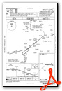
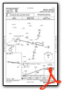
Nearby Airports with Instrument Procedures
| ID | Name | Heading / Distance | ||
|---|---|---|---|---|
 |
KDDH | William H Morse State Airport | 344° | 12.2 |
|
KPSF | Pittsfield Municipal Airport | 198° | 17.0 |
|
KALB | Albany International Airport | 276° | 28.1 |
|
0B5 | Turners Falls Airport | 102° | 29.4 |
|
4B0 | South Albany Airport | 254° | 30.5 |
|
KGBR | Walter J Koladza Airport | 198° | 32.4 |
|
7B2 | Northampton Airport | 131° | 33.2 |
|
1B1 | Columbia County Airport | 224° | 34.1 |
|
KSCH | Schenectady County Airport | 285° | 34.8 |
|
5B2 | Saratoga County Airport | 305° | 37.2 |
|
KBAF | Westfield-Barnes Regional Airport | 147° | 38.1 |
|
KORE | Orange Municipal Airport | 100° | 39.8 |
Airport Images

By: kcmacm

By: trevorgilman1@y...


