Login
Register


ARB
Ann Arbor Municipal Airport
Official FAA Data Effective 2024-04-18 0901Z
Chart Supplement

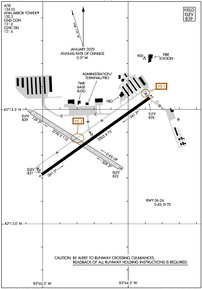
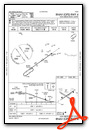
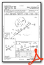
KARB Airport Diagram
VFR Chart of KARB
Sectional Charts at SkyVector.com
IFR Chart of KARB
Enroute Charts at SkyVector.com
Location Information for KARB
Coordinates: N42°13.38' / W83°44.74'Located 03 miles S of Ann Arbor, Michigan on 837 acres of land. View all Airports in Michigan.
Estimated Elevation is 839 feet MSL.
Operations Data
|
|
Airport Communications
| ATIS: | 134.55 |
|---|---|
| ASOS: | Tel. 734-668-7173 |
| ANN ARBOR TOWER: | 120.3 |
| ANN ARBOR GROUND: | 121.6 |
| DETROIT APPROACH: | 118.95 284.0 |
| DETROIT DEPARTURE: | 118.95 284.0 |
| CLEARANCE DELIVERY: | 121.6 |
| UNICOM: | 123.000 |
| CTAF: | 120.300 |
| EMERG: | 121.5 |
| ATIS at YIP (9.6 E): | 127.425 |
| ASOS at YIP (10.0 E): | 734-961-6843 |
| ASOS at DTW (17.5 E): | 734-955-5015 |
Nearby Navigation Aids
|
| ||||||||||||||||||||||||||||||||||||||||||||||||||||||||||||


Runway 06/24
| Dimensions: | 3505 x 75 feet / 1068 x 23 meters | |
|---|---|---|
| Surface: | Concrete / Grooved in Fair Condition | |
| Weight Limits: | S-45, D-70 | |
| Edge Lighting: | Medium Intensity | |
| Runway 06 | Runway 24 | |
| Coordinates: | N42°13.21' / W83°45.01' | N42°13.55' / W83°44.37' |
| Elevation: | 831.3 | 826.0 |
| Traffic Pattern: | Left | Left |
| Runway Heading: | 55° True | 235° True |
| Markings: | Non-Precision Instrument in good condition. | Non-Precision Instrument in good condition. |
| Glide Slope Indicator | P4L (3.00° Glide Path Angle) | V2L (3.00° Glide Path Angle) |
| REIL: | Yes | |
| Obstacles: | 59 ft Road 1061 ft from runway, 344 ft right of center | |
Runway 12/30
NO SNOW REMOVAL. | ||
| Dimensions: | 2750 x 110 feet / 838 x 34 meters | |
|---|---|---|
| Surface: | Turf in Fair Condition | |
| Runway 12 | Runway 30 | |
| Coordinates: | N42°13.49' / W83°45.07' | N42°13.25' / W83°44.55' |
| Elevation: | 839.0 | 822.0 |
| Traffic Pattern: | Left | Left |
| Runway Heading: | 122° True | 302° True |
| Obstacles: | 44 ft Tree 742 ft from runway, 219 ft left of center | 66 ft Tree 1048 ft from runway, 248 ft right of center |
Services Available
| Fuel: | 100LL (blue), Jet A+ |
|---|---|
| Transient Storage: | Hangars,Tiedowns |
| Airframe Repair: | MAJOR |
| Engine Repair: | MAJOR |
| Bottled Oxygen: | HIGH/LOW |
| Bulk Oxygen: | HIGH/LOW |
| Other Services: | PILOT INSTRUCTION,AIRCRAFT RENTAL |
Ownership Information
| Ownership: | Publicly owned | |
|---|---|---|
| Owner: | CITY OF ANN ARBOR | |
| PO BOX 8647 | ||
| ANN ARBOR, MI 48107-8647 | ||
| 734-994-2841 | ||
| Manager: | MATTHEW KULHANEK | |
| 801 AIRPORT DR | ||
| ANN ARBOR, MI 48108-9703 | ||
| 734-994-9124 | ||
Operational Statistics
| Single Engine Aircraft Based on Field: | 137 | Statistics collected for 12 month period ending 2021-12-31 | |
|---|---|---|---|
| Multi-Engine Aircraft Based on Field: | 14 | Annual Commercial Operations: | none |
| Jet Aircraft Based on Field: | 1 | Annual Commuter Operations: | none |
| Helicopters Based on Field: | 6 | Annual Air Taxi Operations: | none |
| Military Aircraft Based on Field: | none | Annual Military Operations: | none |
| Gliders Based on Field: | 1 | Annual GA Local Operations: | 47336 |
| Ultralights Based on Field: | none | Annual GA Itinerant Operations: | 27997 |
Other Remarks
- DEER & BIRDS ON & INVOF ARPT.
- WHEN ATCT CLSD CONFIRM SNOW REMOVAL OPNS & WINTER CONDS - CTAF.
- RWY 24 RUNUP AREA FIRST 200 FT OF TWY A; TWY A1 BTN TWY A & RWY 24 HOLD LINE NOT VSB FM TWR.
- FOR CD WHEN ATCT IS CLSD CTC DETROIT APCH AT 734-955-1404.
- 3 FT YELLOW CONES.
- 3 FT YELLOW CONES.
- WHEN ATCT CLSD ACTVT REIL RWY 06; PAPI RWY 06; VASI RWY 24; MIRL RWY 06/24 - CTAF.
Weather Minimums
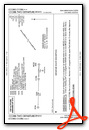
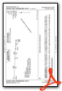
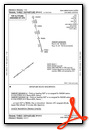
Standard Terminal Arrival (STAR) Charts
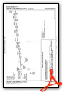
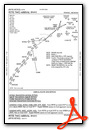
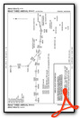
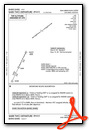
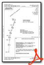
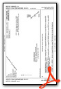
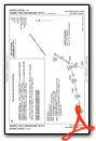
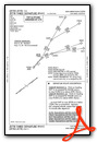
Instrument Approach Procedure (IAP) Charts

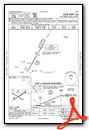
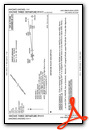
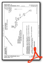
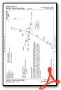
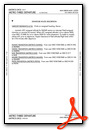
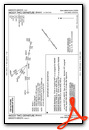
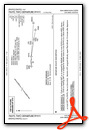
Departure Procedure (DP) Charts
Nearby Airports with Instrument Procedures
| ID | Name | Heading / Distance | ||
|---|---|---|---|---|
 |
KYIP | Willow Run Airport | 083° | 9.6 |
|
1D2 | Canton-Plymouth-Mettetal Airport | 059° | 14.9 |
|
KDTW | Detroit Metro Wayne County Airport | 091° | 17.5 |
|
Y47 | Oakland Southwest Airport | 017° | 17.7 |
|
KTTF | Custer Airport | 140° | 21.9 |
|
KADG | Lenawee County Airport | 214° | 26.0 |
|
KOZW | Livingston County Spencer J Hardy Airport | 336° | 26.5 |
|
KONZ | Grosse Ile Municipal Airport | 105° | 27.1 |
|
KDUH | Toledo Suburban Airport | 172° | 29.5 |
|
KPTK | Oakland County International Airport | 028° | 30.2 |
|
KVLL | Oakland/Troy Airport | 052° | 31.7 |
|
KJXN | Jackson County/Reynolds Field Airport | 274° | 32.0 |
Airport Images

By: NEMo1103


Comments
Aviation Center has moved to Jackson (KJXN)
Aviation Center has moved to Jackson (KJXN)
JM
Admin