Login
Register


ARG
Walnut Ridge Regional Airport
Official FAA Data Effective 2024-04-18 0901Z
Chart Supplement

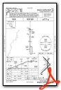
VFR Chart of KARG
Sectional Charts at SkyVector.com
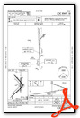
IFR Chart of KARG
Enroute Charts at SkyVector.com
Location Information for KARG
Coordinates: N36°7.48' / W90°55.51'Located 04 miles NE of Walnut Ridge, Arkansas on 1800 acres of land. View all Airports in Arkansas.
Surveyed Elevation is 279 feet MSL.
Operations Data
|
|
Airport Communications
| AWOS-3PT: | 126.525 Tel. 870-886-2537 |
|---|---|
| CTAF: | 122.800 |
| UNICOM: | 122.800 |
| AWOS-3T at 4M9 (21.6 NE): | 118.325 870-857-9702 |
| ASOS at JBR (22.1 SE): | 118.525 870-932-4010 |
| AWOS-3PT at M19 (31.7 SW): | 118.15 870-523-2189 |
- APCH/DEP SVC PRVDD BY MEMPHIS ARTCC ON FREQS 120.075/289.4 (WALNUT RIDGE RCAG).
Nearby Navigation Aids
|
| ||||||||||||||||||||||||||||||||||||||||||||||||||||||||||||


Runway 04/22
| Dimensions: | 6001 x 150 feet / 1829 x 46 meters | |
|---|---|---|
| Surface: | Asphalt in Good Condition | |
| Weight Limits: | S-40, D-60, ST-110 | |
| Edge Lighting: | Medium Intensity | |
| Runway 04 | Runway 22 | |
| Coordinates: | N36°6.81' / W90°56.02' | N36°7.51' / W90°55.16' |
| Elevation: | 279.1 | 272.9 |
| Traffic Pattern: | Left | Left |
| Runway Heading: | 45° True | 225° True |
| Markings: | Non-Precision Instrument in good condition. | Non-Precision Instrument in good condition. |
| Glide Slope Indicator | P4L (3.00° Glide Path Angle) | |
| Approach Lights: | MALSF 1,400 Foot Medium-intensity Approach Lighting System with sequenced flashers. | |
Runway 13/31
| Dimensions: | 5003 x 150 feet / 1525 x 46 meters | |
|---|---|---|
| Surface: | Concrete in Fair Condition | |
| Weight Limits: | S-40, D-60, ST-110 | |
| Runway 13 | Runway 31 | |
| Coordinates: | N36°8.08' / W90°55.88' | N36°7.50' / W90°55.16' |
| Elevation: | 272.2 | 272.8 |
| Traffic Pattern: | Left | Left |
| Runway Heading: | 135° True | 315° True |
| Markings: | Basic in good condition. | Basic in good condition. |
| Obstacles: | 15 ft Road 600 ft from runway | 1 ft Berm 220 ft from runway |
Runway 18/36
| Dimensions: | 5001 x 150 feet / 1524 x 46 meters | |
|---|---|---|
| Surface: | Concrete in Fair Condition | |
| Weight Limits: | S-40, D-60, ST-110 | |
| Edge Lighting: | Medium Intensity | |
| Runway 18 | Runway 36 | |
| Coordinates: | N36°7.96' / W90°55.40' | N36°7.14' / W90°55.40' |
| Elevation: | 273.3 | 272.2 |
| Traffic Pattern: | Left | Left |
| Runway Heading: | 180° True | 0 |
| Markings: | Precision Instrument in good condition. | Precision Instrument in good condition. |
| Approach Lights: | ODALS Omnidirectional Approach Lighting System | |
| REIL: | Yes | |
| Obstacles: | 15 ft Road 1000 ft from runway | |
Services Available
| Fuel: | 100LL (blue), Jet-A |
|---|---|
| Transient Storage: | Hangars,Tiedowns |
| Airframe Repair: | MAJOR |
| Engine Repair: | MAJOR |
| Bottled Oxygen: | NONE |
| Bulk Oxygen: | NONE |
| Other Services: | AIR FREIGHT SERVICES,CROP DUSTING SERVICES,PILOT INSTRUCTION |
Ownership Information
| Ownership: | Publicly owned | |
|---|---|---|
| Owner: | CITY OF WALNUT RIDGE | |
| 300 WEST MAIN STREET | ||
| WALNUT RIDGE, AR 72476 | ||
| 870-886-6638 | ||
| Manager: | STACY HOGGARD | |
| 11 SKY WATCH | ||
| WALNUT RIDGE, AR 72476 | ||
| 870-886-5432 | ||
Operational Statistics
| Single Engine Aircraft Based on Field: | 36 | Statistics collected for 12 month period ending 2023-03-31 | |
|---|---|---|---|
| Multi-Engine Aircraft Based on Field: | 5 | Annual Commercial Operations: | none |
| Jet Aircraft Based on Field: | none | Annual Commuter Operations: | none |
| Helicopters Based on Field: | 5 | Annual Air Taxi Operations: | 300 |
| Military Aircraft Based on Field: | none | Annual Military Operations: | 2500 |
| Gliders Based on Field: | none | Annual GA Local Operations: | 30000 |
| Ultralights Based on Field: | none | Annual GA Itinerant Operations: | 7200 |
Other Remarks
- GOVERNMENT CONTRACT FUEL AVBL.
- AGRICULTURAL OPS ON AND INVOF ARPT APR THRU SEP.
- MIGRATORY BIRDS INVOF ARPT OCT THRU JAN.
- FOR CD CTC MEMPHIS ARTCC AT 901-368-8453/8449.
- 0LL SELF SVC FUEL AVBL 24 HRS WITH CC/FULL SVC AVBL 0800-1700.
- JET A SELF SVC FUEL AVBL 24 HRS WITH CC/FULL SVC AVBL 0800-1700.
- ACTVT MALSF RWY 04; ODALS RWY 18; REIL RWY 18; MIRL RWY 04/22, RWY 18/36 - CTAF.
Weather Minimums

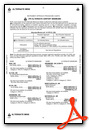
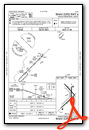
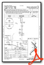
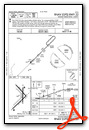
Instrument Approach Procedure (IAP) Charts
Nearby Airports with Instrument Procedures
| ID | Name | Heading / Distance | ||
|---|---|---|---|---|
 |
M70 | Pocahontas Municipal Airport | 348° | 7.4 |
|
KPGR | Kirk Field Airport | 100° | 20.6 |
|
4M9 | Corning Municipal Airport | 038° | 21.5 |
|
KJBR | Jonesboro Municipal Airport | 142° | 22.2 |
|
M19 | Newport Regional Airport | 202° | 31.6 |
|
KCVK | Sharp County Regional Airport | 285° | 32.1 |
|
KMXA | Manila Municipal Airport | 109° | 40.0 |
|
6M2 | Horseshoe Bend Airport | 278° | 40.8 |
|
KBVX | Batesville Regional Airport | 236° | 42.5 |
|
KTKX | Kennett Memorial Airport | 081° | 43.6 |
|
42A | Melbourne Municipal - John E Miller Field Airport | 266° | 44.1 |
|
KPOF | Poplar Bluff Regional Business Airport | 036° | 48.6 |
Fuel Providers

Airport Images
Do you have a recent image of this airport? Upload it here!


