Login
Register


ASW
Warsaw Municipal Airport
Official FAA Data Effective 2024-04-18 0901Z
Chart Supplement

VFR Chart of KASW
Sectional Charts at SkyVector.com
IFR Chart of KASW
Enroute Charts at SkyVector.com
Location Information for KASW
Coordinates: N41°16.48' / W85°50.40'Located 02 miles N of Warsaw, Indiana on 557 acres of land. View all Airports in Indiana.
Surveyed Elevation is 849 feet MSL.
Operations Data
|
|
Airport Communications
| AWOS-3: | 121.125 Tel. 574-269-7035 |
|---|---|
| FORT WAYNE APPROACH: | 127.2 284.6 |
| FORT WAYNE DEPARTURE: | 127.2 284.6 |
| CLEARANCE DELIVERY: | 134.05 |
| UNICOM: | 122.700 |
| CTAF: | 122.700 |
| ASOS at GSH (15.3 N): | 121.45 574-642-4231 |
| AWOS-3 at RCR (19.9 SW): | 118.775 574-223-3560 |
| AWOS-3 at C65 (21.4 W): | 133.025 574-935-3854 |
- APCH CTL SECTORIZATION BASED UPON FORT WAYNE RWY USAGE.
Nearby Navigation Aids
|
| ||||||||||||||||||||||||||||||||||||||||||||||||||||||||||||


Runway 09/27
| Dimensions: | 6001 x 100 feet / 1829 x 30 meters | |
|---|---|---|
| Surface: | Asphalt / Grooved in Good Condition | |
| Weight Limits: | S-46, D-75 | |
| Edge Lighting: | High Intensity | |
| Runway 09 | Runway 27 | |
| Coordinates: | N41°16.34' / W85°50.77' | N41°16.36' / W85°49.46' |
| Elevation: | 837.4 | 849.5 |
| Runway Heading: | 89° True | 269° True |
| Displaced Threshold: | 901 Feet | |
| Declared Distances: | TORA:5100 TODA:5100 ASDA:5100 LDA:5100 | TORA:6000 TODA:6000 ASDA:6000 LDA:5100 |
| Markings: | Non-Precision Instrument in fair condition. | Precision Instrument in fair condition. |
| Glide Slope Indicator | P2L (3.00° Glide Path Angle) | P4L (3.00° Glide Path Angle) |
| REIL: | Yes | Yes |
| Obstacles: | 41 ft Pole 1460 ft from runway, 10 ft right of center | 166 ft Tower 5600 ft from runway, 200 ft right of center CLOSEST ESTD INTCP OF TALLEST TWR. APCH SLOPE 34:1 TO DTHR. 6 FT FENCE 1045 FT FM RWY END; 15 FT ROAD 1070 FT FM RWY END. |
Runway 18/36
| Dimensions: | 4021 x 75 feet / 1226 x 23 meters | |
|---|---|---|
| Surface: | Asphalt in Fair Condition | |
| Weight Limits: | S-15 | |
| Edge Lighting: | Medium Intensity | |
| Runway 18 | Runway 36 | |
| Coordinates: | N41°17.00' / W85°50.84' | N41°16.34' / W85°50.82' |
| Elevation: | 839.7 | 836.5 |
| Traffic Pattern: | Left | Left |
| Runway Heading: | 179° True | 359° True |
| Markings: | Non-Precision Instrument in fair condition. | Non-Precision Instrument in fair condition. |
| Glide Slope Indicator | V4L (3.50° Glide Path Angle) | |
| Obstacles: | 15 ft Road 495 ft from runway | 28 ft Tree 1000 ft from runway, 165 ft left of center |
Services Available
| Fuel: | 100LL (blue), Jet-A |
|---|---|
| Transient Storage: | Hangars,Tiedowns PPR - AMGR. |
| Airframe Repair: | MAJOR |
| Engine Repair: | MAJOR |
| Bottled Oxygen: | NOT AVAILABLE |
| Bulk Oxygen: | NOT AVAILABLE |
| Other Services: | AIR FREIGHT SERVICES,CHARTER SERVICE,PILOT INSTRUCTION,AIRCRAFT RENTAL |
Ownership Information
| Ownership: | Publicly owned | |
|---|---|---|
| Owner: | WARSAW BOAC | |
| 3000 AIRPORT DR | ||
| WARSAW, IN 46582 | ||
| 574-269-1337 | ||
| Manager: | NICHOLAS KING | |
| 3000 AIRPORT DR | ||
| WARSAW, IN 46582 | ||
| 574-269-1337 | ||
Operational Statistics
| Single Engine Aircraft Based on Field: | 36 | Statistics collected for 12 month period ending 2019-12-31 | |
|---|---|---|---|
| Multi-Engine Aircraft Based on Field: | 2 | Annual Commercial Operations: | none |
| Jet Aircraft Based on Field: | 3 | Annual Commuter Operations: | none |
| Helicopters Based on Field: | 2 | Annual Air Taxi Operations: | 669 |
| Military Aircraft Based on Field: | none | Annual Military Operations: | none |
| Gliders Based on Field: | none | Annual GA Local Operations: | 8960 |
| Ultralights Based on Field: | none | Annual GA Itinerant Operations: | 3744 |
Other Remarks
- FOR CD CTC CHICAGO ARTCC AT 630-906-8921.
- ACTVT REIL RWY 09 & 27; PAPI RWY 09 & 27; MIRL RWY 18/36 - CTAF. VASI RWY 18 OPR CONSLY. HIRL RWY 09/27 PRESET TO LOW INTST; INCR INTST - CTAF.
Weather Minimums

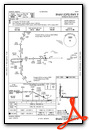
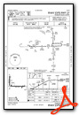
Instrument Approach Procedure (IAP) Charts

Nearby Airports with Instrument Procedures
| ID | Name | Heading / Distance | ||
|---|---|---|---|---|
 |
C03 | Nappanee Municipal Airport | 337° | 11.2 |
|
KGSH | Goshen Municipal Airport | 007° | 15.2 |
|
KRCR | Fulton County Airport | 231° | 19.9 |
|
C65 | Plymouth Municipal Airport | 284° | 21.5 |
|
KEKM | Elkhart Municipal Airport | 344° | 27.7 |
|
C62 | Kendallville Municipal Airport | 065° | 28.7 |
|
KHHG | Huntington Municipal Airport | 145° | 30.7 |
|
KIWH | Wabash Municipal Airport | 176° | 30.8 |
|
KSMD | Smith Field Airport | 103° | 32.1 |
|
I76 | Peru Municipal Airport | 205° | 32.5 |
|
KSBN | South Bend International Airport | 320° | 33.7 |
|
KFWA | Fort Wayne International Airport | 121° | 34.2 |
Airport Images
Do you have a recent image of this airport? Upload it here!


Comments
Great Airport
Recently on a visit to KASW, we had an issue that Nick King and his staff were able to solve. Their efforts were greatly appreciated. We always receive great service at this wonderful airport. Fuel prices are great as well.