Login
Register


AUN
Auburn Municipal Airport
Official FAA Data Effective 2024-03-21 0901Z
Chart Supplement

VFR Chart of KAUN
Sectional Charts at SkyVector.com
IFR Chart of KAUN
Enroute Charts at SkyVector.com
Location Information for KAUN
Coordinates: N38°57.29' / W121°4.90'Located 03 miles N of Auburn, California on 254 acres of land. View all Airports in California.
Surveyed Elevation is 1538 feet MSL.
HEL TFC PAT 580 FT AGL.
Operations Data
|
|
Airport Communications
| AWOS-3: | 119.375 Tel. 530-888-8934 |
|---|---|
| NORCAL APPROACH: | 125.4 317.5 |
| NORCAL DEPARTURE: | 125.4 317.5 |
| UNICOM: | 122.700 |
| CTAF: | 122.700 |
| AWOS-3 at LHM (12.8 W): | 124.25 916-645-0698 |
| AWOS-3 at GOO (16.5 N): | 121.325 530-273-0029 |
| AWOS-1 at O61 (16.9 S): | 120.0 530-677-5392 |
Nearby Navigation Aids
|
| ||||||||||||||||||||||||||||||||||||


Runway 07/25
| Dimensions: | 3700 x 75 feet / 1128 x 23 meters | |
|---|---|---|
| Surface: | Asphalt in Good Condition | |
| Weight Limits: | S-30 | |
| Edge Lighting: | Medium Intensity | |
| Runway 07 | Runway 25 | |
| Coordinates: | N38°57.26' / W121°5.29' | N38°57.32' / W121°4.52' |
| Elevation: | 1493.0 | 1538.4 |
| Traffic Pattern: | Left HEL RIGHT TFC FOR RWY 07. |
Left |
| Runway Heading: | 84° True | 264° True |
| Displaced Threshold: | 200 Feet | |
| Markings: | Non-Precision Instrument in good condition. | Non-Precision Instrument in good condition. |
| Glide Slope Indicator | P2L (3.00° Glide Path Angle) | P2L (3.50° Glide Path Angle) PAPI UNUSBL BYD 5 DEG LEFT OF CNTRLN |
| Obstacles: | 4 ft Hill 342 ft from runway | 10 ft Hill 425 ft from runway, 90 ft left of center |
Services Available
| Fuel: | 100LL (blue), Jet-A, Jet A-1 |
|---|---|
| Transient Storage: | Hangars,Tiedowns |
| Airframe Repair: | MAJOR |
| Engine Repair: | MAJOR |
| Bottled Oxygen: | HIGH/LOW |
| Bulk Oxygen: | HIGH/LOW |
| Other Services: | AVIONICS,CHARTER SERVICE,PILOT INSTRUCTION,AIRCRAFT RENTAL |
Ownership Information
| Ownership: | Publicly owned | |
|---|---|---|
| Owner: | CITY OF AUBURN | |
| 1225 LINCOLN WAY | ||
| AUBURN, CA 95603 | ||
| 530-823-4211 | ||
| Manager: | TYGHE RICHARDSON | |
| 1225 LINCOLN WAY | ||
| AUBURN, CA 95603 | ||
| 530-888-8174 | ||
Operational Statistics
| Single Engine Aircraft Based on Field: | 206 | Statistics collected for 12 month period ending 2018-12-31 | |
|---|---|---|---|
| Multi-Engine Aircraft Based on Field: | 17 | Annual Commercial Operations: | none |
| Jet Aircraft Based on Field: | 3 | Annual Commuter Operations: | none |
| Helicopters Based on Field: | 9 | Annual Air Taxi Operations: | 1100 |
| Military Aircraft Based on Field: | none | Annual Military Operations: | none |
| Gliders Based on Field: | 1 | Annual GA Local Operations: | 36965 |
| Ultralights Based on Field: | none | Annual GA Itinerant Operations: | 37012 |
Other Remarks
- FUEL 100LL & JET A AVAILABLE 24 HRS
- ULTRALIGHT ACTIVITY ON AND INVOF ARPT.
- FOR CD CTC NORCAL APCH AT 916-361-6874.
- NOISE ABATEMENT ALL DEPS MIN PWR WHILE OBSG SAFE ACFT OPS.
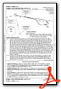
- VFR NOISE ABATEMENT PROC FOR RWY 25 DEP AT END OF RWY TRACK 230 OVER SELF-STORAGE FAC TO AVOID NOISE SENSITIVE AREAS. TURN ON CRS AFTER RCHG 2500 MSL.
- ACTVT PAPI RWY 07; MIRL RWY 07/25 - CTAF. PAPI RWY 25 OPER CONTINUOUS
- HEL TFC PAT 580 FT AGL.
Weather Minimums
Instrument Approach Procedure (IAP) Charts
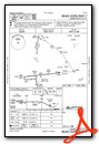
Departure Procedure Obstacles (DPO) Charts
Nearby Airports with Instrument Procedures
| ID | Name | Heading / Distance | ||
|---|---|---|---|---|
 |
KLHM | Lincoln Regional/Karl Harder Field Airport | 257° | 12.9 |
|
KGOO | Nevada County Airport | 012° | 16.6 |
|
KBAB | Beale AFB Airport | 303° | 19.8 |
|
KPVF | Placerville Airport | 131° | 20.7 |
|
KMCC | Mc Clellan Airfield Airport | 221° | 22.8 |
|
KMYV | Yuba County Airport | 290° | 24.4 |
|
KMHR | Sacramento Mather Airport | 202° | 26.0 |
|
KSMF | Sacramento International Airport | 237° | 28.5 |
|
KSAC | Sacramento Exec Airport | 216° | 32.8 |
|
KJAQ | Westover Field Amador County Airport | 158° | 37.2 |
|
O41 | Watts-Woodland Airport | 245° | 40.7 |
|
KOVE | Oroville Municipal Airport | 321° | 40.7 |
Fuel Providers


We proudly offer fuel from:

US Dollar per US Gallon
Price Guaranteed by FBO
Airport Images

By: pgvardara@icloud.com

By: Alexsipilot
- 1 of 2
- next ›


