Login
Register


AUO
Auburn University Regional Airport
Official FAA Data Effective 2024-04-18 0901Z
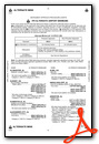
Chart Supplement

VFR Chart of KAUO
Sectional Charts at SkyVector.com
IFR Chart of KAUO
Enroute Charts at SkyVector.com
Location Information for KAUO
Coordinates: N32°36.91' / W85°26.04'Located 02 miles E of Auburn, Alabama on 423 acres of land. View all Airports in Alabama.
Surveyed Elevation is 776 feet MSL.
Operations Data
|
|
Airport Communications
| AWOS-3PT: | 132.575 Tel. 334-501-0387 |
|---|---|
| ATLANTA APPROACH: | 125.5 126.55 ;7000 FT & ABV 323.1 ;BLW 7000 FT 353.75 ;7000 FT & ABV |
| ATLANTA DEPARTURE: | 125.5 126.55 ;7000 FT & ABV 323.1 ;BLW 7000 FT 353.75 ;7000 FT & ABV |
| CLEARANCE DELIVERY: | 118.7 |
| UNICOM: | 123.000 |
| CTAF: | 123.000 |
| ASOS at CSG (25.6 E): | 706-576-4715 |
| ATIS at CSG (25.7 E): | 127.75 |
| ATIS at LSF (28.3 SE): | 134.375 |
- APCH/DEP SVC PRVDD BY ATLANTA LARGE TRACON 125.5 (0515-2200) OTHER TIMES ATLANTA ARTCC 120.45/298.850 (COLUMBUS RCAG).
- CLNC DEL PRVDD BY ATLANTA LARGE TRACON 118.7 (0515-2200) OTHER TIMES ATLANTA ARTCC 120.45/298.850 (COLUMBUS RCAG).
Nearby Navigation Aids
|
| ||||||||||||||||||||||||||||||||||||||||||||||||||||||||||||


Runway 18/36
| Dimensions: | 5264 x 100 feet / 1604 x 30 meters | |
|---|---|---|
| Surface: | Asphalt / Grooved in Excellent Condition | |
| Weight Limits: | S-45, D-75 | |
| Edge Lighting: | High Intensity | |
| Runway 18 | Runway 36 | |
| Coordinates: | N32°37.21' / W85°26.16' | N32°36.34' / W85°26.18' |
| Elevation: | 776.8 | 731.1 |
| Traffic Pattern: | Left | Left |
| Runway Heading: | 181° True | 1° True |
| Markings: | Precision Instrument in good condition. | Precision Instrument in good condition. |
| Glide Slope Indicator | P4L (3.00° Glide Path Angle) | |
| Approach Lights: | MALSF 1,400 Foot Medium-intensity Approach Lighting System with sequenced flashers. | |
| Obstacles: | 15 ft Tree 411 ft from runway, 194 ft right of center | 35 ft Tree 1560 ft from runway, 163 ft right of center |
Runway 11/29
| Dimensions: | 4000 x 75 feet / 1219 x 23 meters | |
|---|---|---|
| Surface: | Asphalt in Excellent Condition | |
| Weight Limits: | S-25, D-42 | |
| Edge Lighting: | Medium Intensity | |
| Runway 11 | Runway 29 | |
| Coordinates: | N32°37.17' / W85°26.24' | N32°36.98' / W85°25.50' |
| Elevation: | 774.9 | 766.3 |
| Traffic Pattern: | Left | Left |
| Runway Heading: | 107° True | 287° True |
| Displaced Threshold: | 297 Feet | |
| Markings: | Non-Precision Instrument in fair condition. | Non-Precision Instrument in fair condition. |
| Glide Slope Indicator | P4L (3.00° Glide Path Angle) | |
| Obstacles: | 17 ft Trees 373 ft from runway, 191 ft left of center | 30 ft Tree 490 ft from runway, 14 ft left of center APCH RATIO 26:1 FROM DSPLCD THLD. |
Services Available
| Fuel: | 100LL (blue), Jet-A, Jet A+ |
|---|---|
| Transient Storage: | Tiedowns |
| Airframe Repair: | MINOR |
| Engine Repair: | MINOR |
| Bottled Oxygen: | NONE |
| Bulk Oxygen: | HIGH/LOW |
| Other Services: | CHARTER SERVICE,PILOT INSTRUCTION,AIRCRAFT RENTAL,AIRCRAFT SALES |
Ownership Information
| Ownership: | Publicly owned | |
|---|---|---|
| Owner: | AUBURN UNIVERSITY | |
| 2150 BENT CREEK RD. | ||
| AUBURN, AL 36830 | ||
| 334-844-4597 | ||
| Manager: | WILLIAM T. HUTTO | |
| 2150 BENT CREEK RD. | ||
| AUBURN, AL 36830 | ||
| 334-844-4606 | ||
Operational Statistics
| Single Engine Aircraft Based on Field: | 93 | Statistics collected for 12 month period ending 2021-12-31 | |
|---|---|---|---|
| Multi-Engine Aircraft Based on Field: | 22 | Annual Commercial Operations: | none |
| Jet Aircraft Based on Field: | 4 | Annual Commuter Operations: | none |
| Helicopters Based on Field: | none | Annual Air Taxi Operations: | 3882 |
| Military Aircraft Based on Field: | none | Annual Military Operations: | 228 |
| Gliders Based on Field: | none | Annual GA Local Operations: | 77207 |
| Ultralights Based on Field: | none | Annual GA Itinerant Operations: | 29105 |
Other Remarks
- JET START CPBLTY AVBL.
- TMPRY ATCT BY NOTAM FOR SPL EVENTS.
- SAWRS WX AVBL ON REQ.
- HVY FLT STUDENT ACTVTY WI 35NM OF ARPT.
- 0LL SVC AFT HRS & HOL 334-501-3100.
- ACTVT MALSF RWY 36; PAPI RWY 29 & 36; MIRL RWY 11/29; HIRL RWY 18/36 - CTAF
Weather Minimums

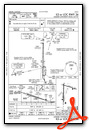
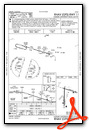
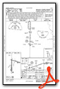
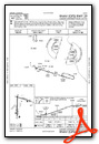
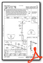
Instrument Approach Procedure (IAP) Charts
Nearby Airports with Instrument Procedures
| ID | Name | Heading / Distance | ||
|---|---|---|---|---|
 |
06A | Moton Field Municipal Airport | 233° | 15.5 |
|
7A3 | Lanett Regional Airport | 041° | 15.7 |
|
KCSG | Columbus Airport | 103° | 25.8 |
|
KLSF | Lawson AAF (Fort Moore) Airport | 126° | 28.3 |
|
KLGC | Lagrange/Callaway Airport | 037° | 29.8 |
|
KPIM | Harris County Airport | 064° | 31.0 |
|
KALX | Thomas C Russell Field Airport | 303° | 32.2 |
|
KEUF | Weedon Field Airport | 158° | 42.7 |
|
11A | Clayton Municipal Airport | 183° | 43.9 |
|
08A | Wetumpka Municipal Airport | 263° | 45.8 |
|
KMXF | Maxwell AFB Airport | 253° | 49.3 |
|
KMGM | Montgomery Regional (Dannelly Field) Airport | 249° | 52.2 |
Airport Images
Do you have a recent image of this airport? Upload it here!


