Login
Register


AWM
West Memphis Municipal Airport
Official FAA Data Effective 2024-04-18 0901Z
Chart Supplement

VFR Chart of KAWM
Sectional Charts at SkyVector.com
IFR Chart of KAWM
Enroute Charts at SkyVector.com
Location Information for KAWM
Coordinates: N35°8.10' / W90°14.07'Located 03 miles W of West Memphis, Arkansas on 494 acres of land. View all Airports in Arkansas.
Surveyed Elevation is 212 feet MSL.
Operations Data
|
|
Airport Communications
| ASOS: | 118.175 Tel. 870-733-9987 |
|---|---|
| MEMPHIS APPROACH: | 119.1 126.7 291.6 |
| MEMPHIS DEPARTURE: | 124.65 284.7 |
| CLEARANCE DELIVERY: | 121.7 |
| CTAF: | 123.050 |
| UNICOM: | 123.050 |
| AWOS-3PT at M01 (9.7 NE): | 118.35 901-354-9296 |
| ASOS at MEM (13.1 E): | 127.75 901-842-8483 |
| D-ATIS at MEM (13.8 SE): | 127.75 |
Nearby Navigation Aids
|
| ||||||||||||||||||||||||||||||||||||||||||||||||||||||||||||


Runway 17/35
| Dimensions: | 6003 x 100 feet / 1830 x 30 meters | |
|---|---|---|
| Surface: | Concrete in Good Condition | |
| Weight Limits: | 33 /R/D/W/T, S-85, D-104, ST-167 | |
| Edge Lighting: | Medium Intensity | |
| Runway 17 | Runway 35 | |
| Coordinates: | N35°8.60' / W90°14.06' | N35°7.61' / W90°14.07' |
| Elevation: | 212.4 | 212.4 |
| Traffic Pattern: | Left | Left |
| Runway Heading: | 181° True | 1° True |
| Markings: | Precision Instrument in good condition. | Non-Precision Instrument in good condition. |
| Glide Slope Indicator | P4L (3.00° Glide Path Angle) | |
| Approach Lights: | MALSR 1,400 Foot Medium-intensity Approach Lighting System with runway alignment indicator lights. | |
| REIL: | Yes | |
Services Available
| Fuel: | 100LL (blue), Jet-A |
|---|---|
| Transient Storage: | Hangars,Tiedowns |
| Airframe Repair: | MAJOR |
| Engine Repair: | MAJOR |
| Bottled Oxygen: | NONE |
| Bulk Oxygen: | NONE |
| Other Services: | AIR FREIGHT SERVICES,CHARTER SERVICE,PILOT INSTRUCTION,AIRCRAFT RENTAL,AIRCRAFT SALES |
Ownership Information
| Ownership: | Publicly owned | |
|---|---|---|
| Owner: | CITY OF WEST MEMPHIS | |
| PO BOX 1728 | ||
| WEST MEMPHIS, AR 72303 | ||
| 870-732-7500 | ||
| Manager: | CANDRA SUITER | |
| 737 SOUTH AIRPORT RD | ||
| WEST MEMPHIS, AR 72301 | ||
| 870-735-4656 | ||
Operational Statistics
| Single Engine Aircraft Based on Field: | 70 | Statistics collected for 12 month period ending 2021-10-31 | |
|---|---|---|---|
| Multi-Engine Aircraft Based on Field: | 20 | Annual Commercial Operations: | none |
| Jet Aircraft Based on Field: | 3 | Annual Commuter Operations: | none |
| Helicopters Based on Field: | 1 | Annual Air Taxi Operations: | none |
| Military Aircraft Based on Field: | none | Annual Military Operations: | 200 |
| Gliders Based on Field: | none | Annual GA Local Operations: | 7000 |
| Ultralights Based on Field: | none | Annual GA Itinerant Operations: | 43000 |
Other Remarks
- FOR CD CTC MEMPHIS APCH AT 901-842-8457.
- 0LL 100LL AVBL 24 HRS SELF SERVE WITH CREDIT CARD.
- MIRL RY 17/35 PRESET LOW INTST; TO INCR INTST & ACTVT MALSR RY 17; PAPI RY 35; REIL RY 35 - CTAF.
Weather Minimums

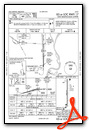
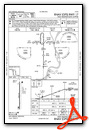
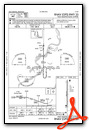
Instrument Approach Procedure (IAP) Charts
Nearby Airports with Instrument Procedures
| ID | Name | Heading / Distance | ||
|---|---|---|---|---|
 |
M01 | General Dewitt Spain Airport | 066° | 9.7 |
|
KMEM | Memphis International Airport | 113° | 13.9 |
|
2M8 | Charles W Baker Airport | 059° | 17.1 |
|
KNQA | Millington/Memphis Airport | 053° | 22.3 |
|
KOLV | Olive Branch/Taylor Field Airport | 112° | 24.0 |
|
KUTA | Tunica Municipal Airport | 191° | 27.5 |
|
KDRP | Delta Regional Airport | 268° | 29.2 |
|
7M4 | Osceola Municipal Airport | 018° | 35.1 |
|
6M7 | Marianna/Lee County-Steve Edwards Field Airport | 233° | 35.4 |
|
KHEE | Thompson-Robbins Airport | 213° | 39.9 |
|
M41 | Holly Springs-Marshall County Airport | 119° | 40.4 |
|
KFYE | Fayette County Airport | 083° | 41.5 |
Airport Images
Do you have a recent image of this airport? Upload it here!


