Login
Register


AWO
Arlington Municipal Airport
Official FAA Data Effective 2024-04-18 0901Z
Chart Supplement

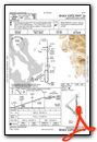
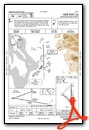
VFR Chart of KAWO
Sectional Charts at SkyVector.com
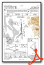
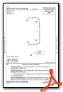
IFR Chart of KAWO
Enroute Charts at SkyVector.com
Location Information for KAWO
Coordinates: N48°9.65' / W122°9.54'Located 03 miles SW of Arlington, Washington on 1200 acres of land. View all Airports in Washington.
Surveyed Elevation is 141 feet MSL.
TPA FOR ULTRALGTS 542 (400), HELICOPTERS 642 (500).
Operations Data
|
|
Airport Communications
| AWOS-3PT: | 135.625 Tel. 360-435-8045 |
|---|---|
| SEATTLE APPROACH: | 128.5 306.9 |
| SEATTLE DEPARTURE: | 128.5 306.9 |
| CLEARANCE DELIVERY: | 121.725 |
| CTAF: | 122.725 |
| ASOS at PAE (15.1 S): | 425-355-6192 |
| ATIS at PAE (16.0 S): | 128.65 |
| AWOS-3 at OKH (21.3 W): | 132.775 360-675-8431 |
Nearby Navigation Aids
|
| ||||||||||||||||||||||||||||||||||||||||||||||||||||||||||||


Runway 16/34
RWY 34 CALM WIND RWY. | ||
| Dimensions: | 5332 x 100 feet / 1625 x 30 meters | |
|---|---|---|
| Surface: | Asphalt in Excellent Condition | |
| Weight Limits: | S-114, D-150, ST-270 | |
| Edge Lighting: | Medium Intensity | |
| Runway 16 | Runway 34 | |
| Coordinates: | N48°10.16' / W122°9.39' | N48°9.28' / W122°9.37' |
| Elevation: | 140.9 | 127.5 |
| Traffic Pattern: | Right | Left |
| Runway Heading: | 179° True | 359° True |
| Markings: | Non-Precision Instrument in good condition. | Non-Precision Instrument in good condition. |
| Glide Slope Indicator | P2L (3.00° Glide Path Angle) | P2L (3.00° Glide Path Angle) |
| Approach Lights: | MALS 1,400 Foot Medium-intensity Approach Lighting System. | |
| REIL: | Yes | |
| Obstacles: | 92 ft Tree 2287 ft from runway, 200 ft left of center | |
Runway 11/29
| Dimensions: | 3498 x 75 feet / 1066 x 23 meters | |
|---|---|---|
| Surface: | Asphalt in Excellent Condition | |
| Weight Limits: | S-32, D-34, ST-59 | |
| Runway 11 | Runway 29 | |
| Coordinates: | N48°9.70' / W122°10.13' | N48°9.35' / W122°9.44' |
| Elevation: | 132.4 | 128.2 |
| Traffic Pattern: | Right | Left |
| Runway Heading: | 127° True | 307° True |
| Markings: | Basic in good condition. | Basic in good condition. |
| Glide Slope Indicator | P2L (3.50° Glide Path Angle) | P2L (4.00° Glide Path Angle) |
| REIL: | Yes | Yes |
| Obstacles: | 176 ft Tree 3967 ft from runway, 465 ft right of center | |
Services Available
| Fuel: | 100LL (blue), Jet-A |
|---|---|
| Transient Storage: | Tiedowns PILOTS PROVIDE OWN ROPES. |
| Airframe Repair: | MAJOR |
| Engine Repair: | MAJOR |
| Bottled Oxygen: | NONE |
| Bulk Oxygen: | NONE |
| Other Services: | AIR AMBULANCE SERVICES,AVIONICS,CARGO HANDLING SERVICES,CHARTER SERVICE,GLIDER SERVICE,PILOT INSTRUCTION,AIRCRAFT RENTAL,AIRCRAFT SALES,ANNUAL SURVEYING,GLIDER TOWING SERVICES |
Ownership Information
| Ownership: | Publicly owned | |
|---|---|---|
| Owner: | CITY OF ARLINGTON | |
| CITY HALL, 238 N OLYMPIC | ||
| ARLINGTON, WA 98223 | ||
| 360-403-3470 | ||
| Manager: | DAVID RYAN | |
| 18204 59TH AVE NE, STE A | ||
| ARLINGTON, WA 98223 | ||
| 360-403-3474 | ||
Operational Statistics
| Single Engine Aircraft Based on Field: | 179 | Statistics collected for 12 month period ending 2022-12-31 | |
|---|---|---|---|
| Multi-Engine Aircraft Based on Field: | 5 | Annual Commercial Operations: | none |
| Jet Aircraft Based on Field: | 1 | Annual Commuter Operations: | none |
| Helicopters Based on Field: | 3 | Annual Air Taxi Operations: | 2325 |
| Military Aircraft Based on Field: | none | Annual Military Operations: | 80 |
| Gliders Based on Field: | 39 | Annual GA Local Operations: | 42685 |
| Ultralights Based on Field: | 20 | Annual GA Itinerant Operations: | 21990 |
Other Remarks
- GLIDER OPERATIONS AT ARPT DAILY.
- RWY 11/29 TURF LCTD BTN D2 AND D3 DIMENSIONS 1400 FT X 100 FT.
- ULTRALIGHT AND POWERED PARACHUTE OPS DAILY WEST OF RWY 16/34
- OCCASIONAL HOT AIR BALLOON ACTIVITY.
- WILDLIFE ON AND INVOF ARPT. ALTERNATE PHONE NUMBER FOR AIRPORT: 360-403-3470
- WINTER WEATHER OPERATIONS AND REPORTING MONDAY-FRIDAY 1600-0000Z.
- FOR ADDNL DETAILS & RULES ON LOCAL PROCS CALL 360-403-3470.
- FOR CD WHEN ATCT IS CLSD CTC SEATTLE APCH AT 206-214-4722.
- GLDR TURF PARL EAST OF RWY 16/34, FULL LEN DIMENSIONS 4000 FT X 145 FT.
- 0LL 100L FUEL AVBL 24 HR CREDIT CARD SVC.
- PHONE 360-435-5700 FOR AFTER HRS SVC.
- REIL RWY 11 & 29 OPR SS-SR; PAPI RWY 11, 16, 29 & 34 OPR CONSLY. ACTVT MALS RWY 34; REILS RWY 16; RWY 16/34 EDGE LIGHTS; TWY LGTS CTAF.
- TPA FOR ULTRALGTS 542 (400), HELICOPTERS 642 (500).
Weather Minimums
Instrument Approach Procedure (IAP) Charts
Departure Procedure (DP) Charts
Nearby Airports with Instrument Procedures
| ID | Name | Heading / Distance | ||
|---|---|---|---|---|
 |
S43 | Harvey Field Airport | 171° | 15.5 |
|
KPAE | Seattle Paine Field International Airport | 198° | 16.0 |
|
KOKH | Delaurentis Airport | 284° | 21.4 |
|
KBVS | Skagit Regional Airport | 330° | 21.4 |
|
KNUW | Whidbey Island NAS (Ault Field) Airport | 300° | 23.0 |
|
0S9 | Jefferson County International Airport | 256° | 27.0 |
|
KBFI | Boeing Field/King County International Airport | 188° | 38.3 |
|
KRNT | Renton Municipal Airport | 183° | 40.1 |
|
KFHR | Friday Harbor Airport | 302° | 40.9 |
|
KBLI | Bellingham International Airport | 338° | 40.8 |
|
KSEA | Seattle-Tacoma International Airport | 188° | 43.1 |
|
KORS | Orcas Island Airport | 317° | 44.5 |
Airport Images
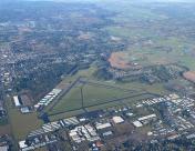
By: kennyw
, looking northeast")
By: paulbeam


