Login
Register


AXN
Chandler Field Airport
Official FAA Data Effective 2024-04-18 0901Z
Chart Supplement

VFR Chart of KAXN
Sectional Charts at SkyVector.com
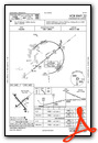
IFR Chart of KAXN
Enroute Charts at SkyVector.com
Location Information for KAXN
Coordinates: N45°51.98' / W95°23.68'Located 02 miles SW of Alexandria, Minnesota on 640 acres of land. View all Airports in Minnesota.
Surveyed Elevation is 1425 feet MSL.
Operations Data
|
|
Airport Communications
| ASOS: | 118.375 Tel. 320-763-7174 |
|---|---|
| CTAF: | 123.000 |
| UNICOM: | 123.000 |
| AWOS-3 at GHW (13.7 S): | 118.925 320-634-5660 |
| AWOS-3 at D39 (21.7 SE): | 118.475 320-352-0136 |
| AWOS-3 at 14Y (21.9 E): | 118.650 320-732-3508 |
- APCH/DEP SVC PRVDD BY MINNEAPOLIS ARTCC ON FREQS 126.1/269.2 (ALEXANDRIA RCAG).
Nearby Navigation Aids
|
| ||||||||||||||||||||||||||||||||||||||||||||||||||||||


Runway 13/31
| Dimensions: | 5099 x 100 feet / 1554 x 30 meters | |
|---|---|---|
| Surface: | Asphalt in Good Condition | |
| Weight Limits: | S-35, D-60 | |
| Edge Lighting: | Medium Intensity | |
| Runway 13 | Runway 31 | |
| Coordinates: | N45°52.30' / W95°24.12' | N45°51.66' / W95°23.34' |
| Elevation: | 1411.5 | 1422.1 |
| Traffic Pattern: | Left | Left |
| Runway Heading: | 139° True | 319° True |
| Markings: | Precision Instrument in good condition. | Precision Instrument in good condition. |
| Glide Slope Indicator | P4L (3.00° Glide Path Angle) | P4L (3.00° Glide Path Angle) |
| Approach Lights: | ODALS Omnidirectional Approach Lighting System | |
| REIL: | Yes | |
| Obstacles: | 59 ft Tree 2033 ft from runway, 544 ft right of center RWY 31 HAS A ROAD IN PRIM SFC 55 FT FM THE RWY END AND 469 FT R |
|
Runway 04/22
| Dimensions: | 4098 x 75 feet / 1249 x 23 meters | |
|---|---|---|
| Surface: | Asphalt in Fair Condition | |
| Weight Limits: | S-35, D-60 | |
| Edge Lighting: | Medium Intensity | |
| Runway 04 | Runway 22 | |
| Coordinates: | N45°51.76' / W95°23.98' | N45°52.20' / W95°23.25' |
| Elevation: | 1425.1 | 1418.4 |
| Traffic Pattern: | Left | Left |
| Runway Heading: | 49° True | 229° True |
| Markings: | Non-Precision Instrument in good condition. | Non-Precision Instrument in good condition. |
| Glide Slope Indicator | P4L (3.00° Glide Path Angle) | P4L (3.00° Glide Path Angle) |
| REIL: | Yes | Yes |
Services Available
| Fuel: | 100LL (blue), Jet-A |
|---|---|
| Transient Storage: | Hangars,Tiedowns |
| Airframe Repair: | MAJOR |
| Engine Repair: | MAJOR |
| Bottled Oxygen: | NONE |
| Bulk Oxygen: | NONE |
| Other Services: | AIR FREIGHT SERVICES,AIR AMBULANCE SERVICES,CHARTER SERVICE,PILOT INSTRUCTION,AIRCRAFT RENTAL,AIRCRAFT SALES |
Ownership Information
| Ownership: | Publicly owned | |
|---|---|---|
| Owner: | CITY OF ALEXANDRIA | |
| 704 BROADWAY | ||
| ALEXANDRIA, MN 56308 | ||
| 320-763-6678 | ||
| Manager: | KREG ANDERSON | |
| 2604 AGA DRIVE | ||
| ALEXANDRIA, MN 56308 | ||
| 320-762-2111 | ||
Operational Statistics
| Single Engine Aircraft Based on Field: | 76 | Statistics collected for 12 month period ending 2017-05-31 | |
|---|---|---|---|
| Multi-Engine Aircraft Based on Field: | 2 | Annual Commercial Operations: | none |
| Jet Aircraft Based on Field: | 1 | Annual Commuter Operations: | none |
| Helicopters Based on Field: | 1 | Annual Air Taxi Operations: | 2200 |
| Military Aircraft Based on Field: | none | Annual Military Operations: | 300 |
| Gliders Based on Field: | none | Annual GA Local Operations: | 8500 |
| Ultralights Based on Field: | 2 | Annual GA Itinerant Operations: | 14500 |
Other Remarks
- WATERFOWL & JACKRABBITS ON & INVOF RY.
- ULTRALIGHT TRAFFIC ON & INVOF ARPT.
- YELLOW BOX ON RAMP RESD FOR MED HEL - BEWARE OF ROTOR BLAST AT TIEDOWNS.
- FOR CD IF UNA TO CTC ON FSS FREQ, CTC MINNEAPOLIS ARTCC AT 651-463-5588.
- FOR FUEL SVC AFT HRS, CTC 320-760-7175.
- MIRL RY 13/31 PRESET ON LOW INTST; TO INCR INTST & ACTVT REIL RY 04/22; PAPI RY 04/22; MIRL RY 04/22; ODALS RY31; REIL RY 13; PAPI RY 13/31; MIRL RY 13/31 - CTAF.
Weather Minimums
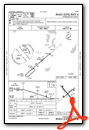
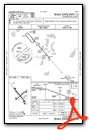
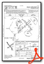
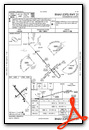
Instrument Approach Procedure (IAP) Charts
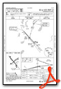
Nearby Airports with Instrument Procedures
| ID | Name | Heading / Distance | ||
|---|---|---|---|---|
 |
KGHW | Glenwood Municipal Airport | 166° | 13.7 |
|
D39 | Sauk Centre Municipal Airport | 116° | 21.6 |
|
14Y | Todd Field Airport | 084° | 21.9 |
|
Y63 | Elbow Lake Municipal/Pride of The Prairie Airport | 286° | 25.8 |
|
KMOX | Morris Municipal/Charlie Schmidt Field Airport | 233° | 30.1 |
|
KBBB | Benson Municipal Airport | 198° | 33.8 |
|
KADC | Wadena Municipal Airport | 012° | 35.9 |
|
KSAZ | Staples Municipal Airport | 038° | 39.4 |
|
KPEX | Paynesville Municipal Airport | 137° | 40.4 |
|
KFFM | Fergus Falls Municipal/Einar Mickelson Field Airport | 308° | 40.5 |
|
KLXL | Little Falls/Morrison County-Lindbergh Field Airport | 083° | 44.2 |
|
KRYM | Ray S Miller AAF Airport | 072° | 45.3 |