Login
Register


BDH
Willmar Municipal/John L Rice Field Airport
Official FAA Data Effective 2024-04-18 0901Z
Chart Supplement

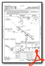
VFR Chart of KBDH
Sectional Charts at SkyVector.com
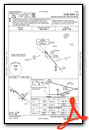
IFR Chart of KBDH
Enroute Charts at SkyVector.com
Location Information for KBDH
Coordinates: N45°7.02' / W95°7.76'Located 02 miles W of Willmar, Minnesota. View all Airports in Minnesota.
Surveyed Elevation is 1126 feet MSL.
Operations Data
|
|
Airport Communications
| AWOS-3PT: | 118.75 Tel. 320-235-8287 |
|---|---|
| CTAF: | 122.800 |
| UNICOM: | 122.800 |
| AWOS-3 at OVL (20.7 S): | 119.275 320-523-5924 |
| AWOS-3PT at PEX (22.3 NE): | 120.35 320-243-4538 |
| AWOS-3PT at BBB (25.5 NW): | 118.45 320-843-3242 |
- APCH/DEP SVC PRVDD BY ZMP ON FREQS 125.5/323.1 (DARWIN RCAG).
Nearby Navigation Aids
|
| ||||||||||||||||||||||||||||||||||||||||||||||||||||||


Runway 13/31
200 FT UNUSBL PAVEMENT BYD RWY, BOTH ENDS. | ||
| Dimensions: | 5500 x 100 feet / 1676 x 30 meters | |
|---|---|---|
| Surface: | Asphalt in Good Condition | |
| Edge Lighting: | High Intensity | |
| Runway 13 | Runway 31 | |
| Coordinates: | N45°7.35' / W95°8.43' | N45°6.77' / W95°7.45' |
| Elevation: | 1123.6 | 1126.0 |
| Runway Heading: | 130° True | 310° True |
| Markings: | Precision Instrument in fair condition. | Precision Instrument in fair condition. |
| Glide Slope Indicator | P4R (3.00° Glide Path Angle) | P4L (3.00° Glide Path Angle) |
| Approach Lights: | MALSR 1,400 Foot Medium-intensity Approach Lighting System with runway alignment indicator lights. | |
| REIL: | Yes | |
| Obstacles: | 76 ft Trees 3934 ft from runway, 766 ft right of center | |
Runway 03/21
NOT PLOWED WINTER MONTHS. | ||
| Dimensions: | 2980 x 250 feet / 908 x 76 meters | |
|---|---|---|
| Surface: | Turf in Fair Condition | |
| Runway 03 | Runway 21 | |
| Coordinates: | N45°6.74' / W95°7.63' | N45°7.14' / W95°7.23' |
| Elevation: | 1125.6 | 1123.0 |
| Runway Heading: | 35° True | 215° True |
| Obstacles: | 4 ft Crops 35 ft from runway, 127 ft left of center | |
Services Available
| Fuel: | 100LL (blue), Jet-A |
|---|---|
| Transient Storage: | Hangars,Tiedowns FOR TSNT HNGR CALL FBO AT 320-214-9669. |
| Airframe Repair: | MAJOR |
| Engine Repair: | MAJOR |
| Bottled Oxygen: | NOT AVAILABLE |
| Bulk Oxygen: | HIGH/LOW |
| Other Services: | PILOT INSTRUCTION,AIRCRAFT SALES |
Ownership Information
| Ownership: | Publicly owned | |
|---|---|---|
| Owner: | CITY OF WILLMAR | |
| PO BOX 755 | ||
| WILLMAR, MN 56201-0755 | ||
| 320-235-4913 | ||
| Manager: | ERIC RUDNINGEN | |
| PO BOX 755, 6600 HIGHWAY 40 W | ||
| WILLMAR, MN 56201-0755 | ||
| 320-894-1872 | ||
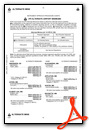
Operational Statistics
| Single Engine Aircraft Based on Field: | 40 | Statistics collected for 12 month period ending 2018-06-30 | |
|---|---|---|---|
| Multi-Engine Aircraft Based on Field: | 8 | Annual Commercial Operations: | none |
| Jet Aircraft Based on Field: | 1 | Annual Commuter Operations: | none |
| Helicopters Based on Field: | 1 | Annual Air Taxi Operations: | 800 |
| Military Aircraft Based on Field: | none | Annual Military Operations: | 50 |
| Gliders Based on Field: | none | Annual GA Local Operations: | 12000 |
| Ultralights Based on Field: | none | Annual GA Itinerant Operations: | 5000 |
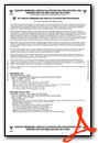
Other Remarks
- ABNDD ARPT 1 NM EAST.
- FOR CD IF UNA TO CTC ON FSS FREQ, CTC MINNEAPOLIS ARTCC AT 651-463-5588.
- YELLOW CONES.
- YELLOW CONES.
- 0LL AVBL H24 SELF SVC VIA CREDIT CARD.
- FOR SVC AFT HRS CALL FBO AT 320-214-9669.
- ACTVT OR INCR INTST MALSR RWY 13; REIL RWY 31; PAPI RWY 13 & 31; HIRL RWY 13/31 - CTAF. HIRL RWY 13/31 PRESET LOW INTST SS-SR.
Weather Minimums
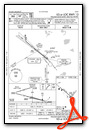
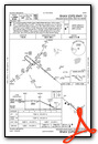
Instrument Approach Procedure (IAP) Charts
Nearby Airports with Instrument Procedures
| ID | Name | Heading / Distance | ||
|---|---|---|---|---|
 |
KOVL | Olivia Regional Airport | 168° | 20.7 |
|
KPEX | Paynesville Municipal Airport | 046° | 22.4 |
|
KBBB | Benson Municipal Airport | 300° | 25.6 |
|
KMVE | Montevideo-Chippewa County Airport | 250° | 26.3 |
|
KLJF | Litchfield Municipal Airport | 092° | 26.5 |
|
KGDB | Granite Falls Municipal/Lenzen-Roe-Fagen Memorial Field Airport | 219° | 28.4 |
|
KGHW | Glenwood Municipal Airport | 345° | 32.6 |
|
KRWF | Redwood Falls Municipal Airport | 176° | 34.3 |
|
KHCD | Hutchinson Municipal/Butler Field Airport | 115° | 35.3 |
|
D39 | Sauk Centre Municipal Airport | 013° | 36.3 |
|
KAQP | Appleton Municipal Airport | 280° | 37.7 |
|
KMOX | Morris Municipal/Charlie Schmidt Field Airport | 307° | 44.5 |
Airport Images
Do you have a recent image of this airport? Upload it here!


