Login
Register


BDL
Bradley International Airport
Official FAA Data Effective 2024-04-18 0901Z
Chart Supplement

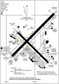
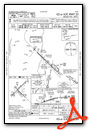
KBDL Airport Diagram
VFR Chart of KBDL
Sectional Charts at SkyVector.com
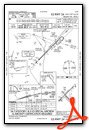
IFR Chart of KBDL
Enroute Charts at SkyVector.com
Location Information for KBDL
Coordinates: N41°56.34' / W72°41.06'Located 03 miles W of Windsor Locks, Connecticut on 2432 acres of land. View all Airports in Connecticut.
Surveyed Elevation is 173 feet MSL.
1700 FT AGL HVY ACFT.
Operations Data
|
|
Airport Communications
| D-ATIS: | 118.15 (860-386-3570) |
|---|---|
| ASOS: | 118.15 Tel. 860-386-3480 |
| BRADLEY TOWER: | 120.3 351.8 |
| BRADLEY GROUND: | 121.9 348.6 |
| BRADLEY APPROACH: | 123.95 ;061-240 125.35 ;241-060 127.225 281.5 ;241-060 290.55 ;061-240 323.2 327.1 |
| BRADLEY DEPARTURE: | 123.95 ;061-240 125.35 ;241-060 281.5 ;241-060 290.55 ;061-240 327.1 |
| IC: | 123.95 ;061-240 125.35 ;241-060 281.5 ;241-060 290.55 ;061-240 |
| CLEARANCE DELIVERY: | 121.75 322.3 |
| CLASS C: | 123.95 ;061-240 125.35 ;241-060 127.225 281.5 ;241-060 290.55 ;061-240 323.2 |
| EMERG: | 121.5 243.0 |
| NG OPS: | 123.45 243.9 41.9 |
| ANG OPS: | 138.55 349.7 |
| CLASS C/S: | 327.1 |
| UNICOM: | 122.950 |
| DEER PARK STAR: | 123.95 ;061-240 125.35 ;241-060 281.5 ;241-060 290.55 ;061-240 |
| STELA STAR: | 125.35 281.5 |
| ATIS at HFD (12.2 S): | 126.45 |
| ASOS at HFD (12.3 S): | 860-527-5837 |
| ATIS at BAF (13.2 N): | 263.15 |
Nearby Navigation Aids
|
| ||||||||||||||||||||||||||||||||||||||||||||||||||||||||||||


Runway 06/24
| Dimensions: | 9510 x 200 feet / 2899 x 61 meters 245 FT BY 200 FT BLAST PAD SW END. | |
|---|---|---|
| Surface: | Asphalt / Grooved in Excellent Condition | |
| Weight Limits: | 71 /F/B/X/T, S-200, D-200, ST-350, DT-710 | |
| Edge Lighting: | High Intensity | |
| Runway 06 | Runway 24 | |
| Coordinates: | N41°55.92' / W72°41.79' | N41°57.04' / W72°40.33' |
| Elevation: | 173.0 | 160.9 |
| Traffic Pattern: | Left | Left |
| Runway Heading: | 44° True | 224° True |
| Declared Distances: | TORA:9509 TODA:9509 ASDA:9509 LDA:9509 | TORA:9509 TODA:9509 ASDA:9509 LDA:9509 |
| Markings: | Precision Instrument in good condition. | Precision Instrument in good condition. |
| Glide Slope Indicator | P4L (3.00° Glide Path Angle) | P4L (3.00° Glide Path Angle) |
| RVR Equipment | Touchdown Midfield Rollout | Touchdown Midfield Rollout |
| Approach Lights: | ALSF2 Standard 2,400 Foot High-intensity Approach Lighting System with sequenced flashers, CATEGORY II or III Configuration. | MALSR 1,400 Foot Medium-intensity Approach Lighting System with runway alignment indicator lights. |
| REIL: | Yes | |
| Centerline Lights: | Yes | Yes |
| Obstacles: | 185 ft Trees 7200 ft from runway, 400 ft right of center | 71 ft Trees 3300 ft from runway |
Runway 15/33
| Dimensions: | 6847 x 150 feet / 2087 x 46 meters 100 FT BY 200 FT BLAST PAD SE END. | |
|---|---|---|
| Surface: | Asphalt / Grooved in Excellent Condition | |
| Weight Limits: | 64 /F/A/X/T, S-200, D-200, ST-350 | |
| Edge Lighting: | High Intensity | |
| Runway 15 | Runway 33 | |
| Coordinates: | N41°56.54' / W72°41.60' | N41°55.76' / W72°40.52' |
| Elevation: | 168.8 | 168.5 |
| Traffic Pattern: | Left | Left |
| Runway Heading: | 134° True | 314° True |
| Declared Distances: | TORA:6847 TODA:6847 ASDA:6847 LDA:6847 | TORA:6847 TODA:6847 ASDA:6847 LDA:6847 |
| Markings: | Non-Precision Instrument in good condition. | Precision Instrument in good condition. |
| Glide Slope Indicator | P4L (3.50° Glide Path Angle) | P4R (3.00° Glide Path Angle) |
| RVR Equipment | Rollout | Touchdown |
| Approach Lights: | MALSF 1,400 Foot Medium-intensity Approach Lighting System with sequenced flashers. | |
| REIL: | Yes | |
| Obstacles: | 75 ft Trees 1700 ft from runway | 44 ft Trees 1700 ft from runway, 430 ft left of center |
Services Available
| Fuel: | 100LL (blue), Jet-A |
|---|---|
| Transient Storage: | Hangars,Tiedowns |
| Airframe Repair: | MAJOR |
| Engine Repair: | MAJOR |
| Bottled Oxygen: | HIGH/LOW |
| Bulk Oxygen: | HIGH/LOW |
| Other Services: | AIR FREIGHT SERVICES,AVIONICS,CARGO HANDLING SERVICES,CHARTER SERVICE,AIRCRAFT SALES |
Ownership Information
| Ownership: | Publicly owned | |
|---|---|---|
| Owner: | CONNECTICUT AIRPORT AUTHORITY | |
| AIRPORT ADMINISTRATION OFFICE, TERMINAL A, 3RD FLOOR | ||
| WINDSOR LOCKS, CT 06096-1022 | ||
| 860-594-2530 | ||
| Manager: | KEVIN DILLON, AAE | |
| BRADLEY INTL AIRPORT | ||
| WINDSOR LOCKS, CT 06096 | ||
| 860-292-2000 | ||
Operational Statistics
| Single Engine Aircraft Based on Field: | none | Statistics collected for 12 month period ending 2023-07-31 | |
|---|---|---|---|
| Multi-Engine Aircraft Based on Field: | 2 | Annual Commercial Operations: | 54803 |
| Jet Aircraft Based on Field: | 27 | Annual Commuter Operations: | none |
| Helicopters Based on Field: | 5 | Annual Air Taxi Operations: | 10025 |
| Military Aircraft Based on Field: | 18 | Annual Military Operations: | 209 |
| Gliders Based on Field: | none | Annual GA Local Operations: | 627 |
| Ultralights Based on Field: | none | Annual GA Itinerant Operations: | 12021 |
Other Remarks
- NMRS BIRDS FQTLY ON OR INVOF ARPT.
- (E117) CT ANG AND U.S. ARMY NG.
- ASDE-X IN USE. OPR TRANSPONDERS WITH ALT RPRTG MODE AND ADS-B (IF EQUIPPED) ENABLED ON ALL ARPT SFCS.
- MILITARY: ANG: NSTD WHITE GND EQPT BOXES PAINTED ON ANG RAMP.
- MILITARY: ARNG - DSN 636-7519/7520. C860-292-4519/4520.
- MILITARY: ANG: AFLD MGR DOES NOT ISSUE OR STORE COMSEC FOR TRAN CREWS.
- OPS CTC AUTOVON 636-8385; COML 860-627-3001.
- CAUTION: ANG RAMP MRK MAY NOT BE APPROPRIATE FOR LARGE ACFT: FLW MARSHALLERS INSTR.
- PARL TWY OPS ON TWY C & TWY B RSTRD TO ACFT WITH WINGSPANS OF 171 FT OR LESS.
- ACFT REQG US CUST SVCS MUST PARK ON THE CUST SPOT W/ THE NOSE OF THE ACFT FACING SW. CTC CUST AT 860-292-1314 WHEN PARKED.
- BASH PHASE II INCRD BIRD ACTVTY SEP-OCT AND MAR-APR.
- FUEL: A++ (MIL).
- FIXED WING ACFT USE LOW IDLE FOR TAXI, NO ENGINE CHECKS OR POWER RUNS ALLOWED ON THE ARNG RAMP DUE TO POSSIBLE FOD HAZARD.
- MILITARY: ANG: WHEN CKG ATIS, BIRDS IN VCY MAY INDC HEIGHTENED BIRD WATCH CONDITION (BWC). USAF ACFT CTC ANG AIRFIELD OPS ON UHF FOR CURRENT BWC & ANY ASSOCD RSTRNS.
- TWY C BTN TWY B & TWY C4 ACFT TAX SPD RSTRN OF 8 KTS/10 MPH MAX FOR ACFT WITH WINGSPAN 214 FT OR GTR.
- LGTD OBST ANT 36 FT AGL/205 FT MSL (RWY 24 ILS/GS ANT) 162 FT NW OF TWY C CNTRLN MARKING BTN TWY B & TWY C4.
- MILITARY: ARNG: OPR 1200-2030Z++ MON, TUE, FRI; 1200-0400++ WED, THU. 41.9 149.825 335.775 (HAVOC OPS).
- RWY 6 DE-ICE PAD CLSD TO ACFT WITH WINGSPAN 171 FT OR GTR EXC WITH FOLLOW-ME ESCORT BY ARPT OPS.
- NON-BASED DVRSN ACRS CTC ARPT OPS 860-627-3001 PRIOR TO DIVG & PRVD CO FLT OPS CTC INFO, ACFT TYPE, POB, INTL OR DOM FLT & GND OPS AGRMTS. ONLY 1 INTL ACR JETBRIDGE AVBL FOR PAX.
- MILITARY: ANG: OG/CC WAIVER ON FILE FOR C-130H/J WITH OPR WT UP TO 155000 LB. ALL OTHER ACFT OVR ANG RAMP PCN RQR WAIVER FR OG/CC THRU AFLD MGMT.
- MILITARY: ANG: OPR 1200-2030Z++ MON-FRI (SAT, SUN UNIT TRNG ASSEMBLY), CLSD HOL.
- MILITARY: ANG: PPR V220-2356.
- NO DE-ICING AVBL AT ANG.
- TWY D CLSD BTN S & D1 TO ACFT WITH WING SPANS IN EXCESS OF 170 FT.
- NO TRNG FLTS, NO PLAS, NO TGLS BTN: 2300 - 0700 MON THRU SAT & 2300 - 1200 SUN.
- LDG FEE FOR BUS/CORPORATE & REVENUE PRODUCING ACFT.
- 1700 FT AGL HVY ACFT.
Weather Minimums
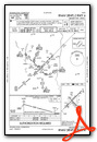
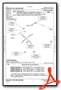
Standard Terminal Arrival (STAR) Charts
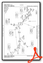
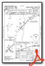
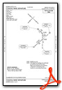
Instrument Approach Procedure (IAP) Charts
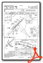
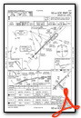

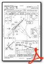
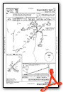
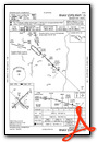
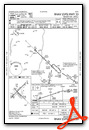
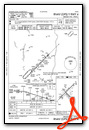
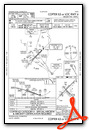
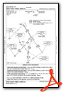
Departure Procedure (DP) Charts
Nearby Airports with Instrument Procedures
| ID | Name | Heading / Distance | ||
|---|---|---|---|---|
 |
KHFD | Hartford-Brainard Airport | 172° | 12.2 |
|
KBAF | Westfield-Barnes Regional Airport | 353° | 13.2 |
|
KCEF | Westover Arb/Metro Airport | 023° | 16.7 |
|
4B8 | Robertson Field Airport | 208° | 17.0 |
|
7B2 | Northampton Airport | 007° | 23.6 |
|
KIJD | Windham Airport | 117° | 25.5 |
|
KMMK | Meriden Markham Municipal Airport | 194° | 26.6 |
|
3B0 | Southbridge Municipal Airport | 071° | 30.5 |
|
KOXC | Waterbury-Oxford Airport | 216° | 34.3 |
|
KSNC | Chester Airport | 166° | 34.3 |
|
KGBR | Walter J Koladza Airport | 294° | 35.3 |
|
0B5 | Turners Falls Airport | 010° | 39.8 |
Fuel Providers

Airport Images
Do you have a recent image of this airport? Upload it here!


Comments
Signature FBO
12/21/2019 - Stopped at Signature FBO for a short break during an IFR training session. What a pleasant group of people and nice facilities!