Login
Register


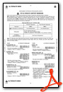
BGE
Decatur County Industrial Air Park Airport
Official FAA Data Effective 2024-04-18 0901Z
Chart Supplement

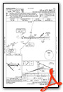
VFR Chart of KBGE
Sectional Charts at SkyVector.com
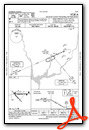
IFR Chart of KBGE
Enroute Charts at SkyVector.com
Location Information for KBGE
Coordinates: N30°58.30' / W84°38.22'Located 06 miles NW of Bainbridge, Georgia on 940 acres of land. View all Airports in Georgia.
Surveyed Elevation is 141 feet MSL.
Operations Data
|
|
Airport Communications
| AWOS-3PT: | 121.125 Tel. 229-248-2104 |
|---|---|
| TALLAHASSEE APPROACH: | 128.7 254.3 |
| TALLAHASSEE DEPARTURE: | 128.7 254.3 |
| CLEARANCE DELIVERY: | 124.775 335.65 |
| UNICOM: | 122.975 |
| CTAF: | 122.975 |
| AWOS-3PT at 17J (12.6 W): | 119.675 229-524-0001 |
| AWOS-3PT at 2J9 (22.8 S): | 118.975 850-627-6264 |
| AWOS-3T at CXU (25.2 NE): | 118.675 229-336-0744 |
- APCH/DEP SVC PRVDD BY JACKSONVILLE ARTCC ON FREQS 128.625/379.175 (TALLAHASSEE RCAG) WHEN TALLAHASSEE APCH CTL CLSD.
Nearby Navigation Aids
|
| ||||||||||||||||||||||||||||||||||||||||||||||||||||||||||||


Runway 09/27
| Dimensions: | 5502 x 149 feet / 1677 x 45 meters | |
|---|---|---|
| Surface: | Asphalt in Good Condition | |
| Weight Limits: | S-24 | |
| Edge Lighting: | High Intensity | |
| Runway 09 | Runway 27 | |
| Coordinates: | N30°58.37' / W84°38.60' | N30°58.37' / W84°37.54' |
| Elevation: | 141.3 | 128.8 |
| Traffic Pattern: | Left | |
| Runway Heading: | 90° True | 270° True |
| Markings: | Precision Instrument in good condition. | Precision Instrument in good condition. |
| Glide Slope Indicator | P2L (3.00° Glide Path Angle) | P2L (3.00° Glide Path Angle) RWY 27 PAPI UNUSBL BYD 8 DEG RIGHT OF RCL. |
| Approach Lights: | MALSR 1,400 Foot Medium-intensity Approach Lighting System with runway alignment indicator lights. | |
| Obstacles: | 51 ft Trees 1475 ft from runway, 557 ft left of center | 93 ft Trees 4478 ft from runway, 606 ft left of center |
Runway 14/32
| Dimensions: | 5003 x 100 feet / 1525 x 30 meters | |
|---|---|---|
| Surface: | Asphalt in Fair Condition | |
| Weight Limits: | S-24 | |
| Runway 14 | Runway 32 | |
| Coordinates: | N30°58.52' / W84°38.69' | N30°57.90' / W84°38.06' |
| Elevation: | 135.0 | 133.6 |
| Traffic Pattern: | Left | |
| Runway Heading: | 139° True | 319° True |
| Markings: | Basic in fair condition. | Basic in fair condition. |
| Obstacles: | 62 ft Trees 1130 ft from runway, 86 ft left of center | |
Services Available
| Fuel: | 100LL (blue), Jet A+ |
|---|---|
| Transient Storage: | Hangars,Tiedowns |
| Airframe Repair: | MINOR |
| Engine Repair: | MINOR |
| Bottled Oxygen: | NONE |
| Bulk Oxygen: | NONE |
| Other Services: | CROP DUSTING SERVICES,PILOT INSTRUCTION,AIRCRAFT RENTAL |
Ownership Information
| Ownership: | Publicly owned | |
|---|---|---|
| Owner: | DECATUR COUNTY | |
| PO BOX 726 | ||
| BAINBRIDGE, GA 39818 | ||
| 229-248-2103 | ||
| Manager: | TOMMY JOHNSON | |
| 413 4TH RAMP | ||
| BAINBRIDGE, GA 39817 | ||
| 229-416-7776 | ||
Operational Statistics
| Single Engine Aircraft Based on Field: | 33 | Statistics collected for 12 month period ending 2023-12-31 | |
|---|---|---|---|
| Multi-Engine Aircraft Based on Field: | 1 | Annual Commercial Operations: | none |
| Jet Aircraft Based on Field: | none | Annual Commuter Operations: | none |
| Helicopters Based on Field: | none | Annual Air Taxi Operations: | none |
| Military Aircraft Based on Field: | none | Annual Military Operations: | 250 |
| Gliders Based on Field: | none | Annual GA Local Operations: | 10000 |
| Ultralights Based on Field: | none | Annual GA Itinerant Operations: | 7100 |
Other Remarks
- EXTENSIVE STUDENT PILOT TRNG ON AND INVOF ARPT.
- FOR CD IF UNA ON FREQ CTC TALLAHASSEE APCH AT 850-942-8311. WHEN APCH CLSD, CTC JACKSONVILLE ARTCC AT 904-845-1592.
- 0LL SELF SVC FUEL 24 HRS WITH CREDIT CARD.
- PAPI RWY 09 & 27 OPR CONSLY DUSK-2200. HIRL RWY 09/27 PRESET MED INTST DUSK-2200; TO INCR INTST - CTAF. AFTER 2200, ACTVT PAPI RWY 09 &27; HIRL RWY 09/27 - CTAF. MALSR RWY 27 - CTAF.
- ALL ACFT OPERATING LOCALLY AT BGE MUST HAVE A TWO-WAY RADIO CAPABLE OF TRANSMITTING/RECEIVING ON CTAF FREQ; ONE-STOP TRANSIENT ACFT ARE EXEMPT FROM THIS REQUIREMENT.
Weather Minimums

Instrument Approach Procedure (IAP) Charts
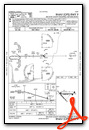

Nearby Airports with Instrument Procedures
| ID | Name | Heading / Distance | ||
|---|---|---|---|---|
 |
17J | Donalsonville Municipal Airport | 279° | 12.6 |
|
2J9 | Quincy Municipal Airport | 169° | 22.7 |
|
KCXU | Camilla-Mitchell County Airport | 054° | 25.2 |
|
70J | Cairo-Grady County Airport | 101° | 25.4 |
|
KBIJ | Early County Airport | 332° | 28.7 |
|
KMAI | Marianna Municipal Airport | 254° | 29.3 |
|
KTLH | Tallahassee International Airport | 156° | 37.5 |
|
KTVI | Thomasville Regional Airport | 095° | 39.2 |
|
KABY | Southwest Georgia Regional Airport | 033° | 40.7 |
|
KHDL | Headland Municipal Airport | 304° | 42.0 |
|
KMGR | Moultrie Municipal Airport | 080° | 43.5 |
|
KDHN | Dothan Regional Airport | 296° | 46.8 |
Airport Images
Do you have a recent image of this airport? Upload it here!


