Login
Register


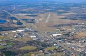
BJI
Bemidji Regional Airport
Official FAA Data Effective 2024-04-18 0901Z
Chart Supplement

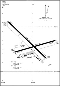
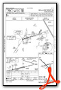
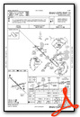
KBJI Airport Diagram
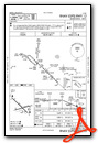
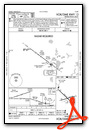
VFR Chart of KBJI
Sectional Charts at SkyVector.com
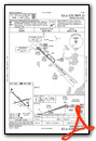
IFR Chart of KBJI
Enroute Charts at SkyVector.com
Location Information for KBJI
Coordinates: N47°30.64' / W94°56.08'Located 03 miles NW of Bemidji, Minnesota on 1740 acres of land. View all Airports in Minnesota.
Surveyed Elevation is 1391 feet MSL.
Operations Data
|
|
Airport Communications
| AWOS-3: | 119.275 Tel. 218-755-2575 |
|---|---|
| CTAF: | 122.800 |
| UNICOM: | 122.800 |
| AWOS-3PT at Y49 (24.2 SE): | 119.0 218-547-2451 |
| AWOS-3 at FSE (34.3 W): | 118.35 218-435-6448 |
| ASOS at PKD (37.0 S): | 119.25 218-732-0920 |
- APCH/DEP SVC PRVDD BY MINNEAPOLIS ARTCC (ZMP) ON FREQS 134.75/251.1 (BEMIDJI RCAG).
Nearby Navigation Aids
|
| ||||||||||||||||||||||||||||||||||||||||||||||||


Runway 13/31
| Dimensions: | 7004 x 150 feet / 2135 x 46 meters | |
|---|---|---|
| Surface: | Asphalt / Grooved in Excellent Condition | |
| Weight Limits: | 11 /F/B/Y/U, S-75, D-200 | |
| Edge Lighting: | High Intensity | |
| Runway 13 | Runway 31 | |
| Coordinates: | N47°31.11' / W94°56.81' | N47°30.31' / W94°55.59' |
| Elevation: | 1391.2 | 1384.2 |
| Runway Heading: | 134° True | 314° True |
| Declared Distances: | TORA:7002 TODA:7002 ASDA:7002 LDA:7002 | TORA:7002 TODA:7002 ASDA:7002 LDA:7002 |
| Markings: | Precision Instrument in good condition. | Precision Instrument in good condition. |
| Glide Slope Indicator | P4L (3.00° Glide Path Angle) | P4L (3.00° Glide Path Angle) |
| Approach Lights: | MALSR 1,400 Foot Medium-intensity Approach Lighting System with runway alignment indicator lights. | MALSR 1,400 Foot Medium-intensity Approach Lighting System with runway alignment indicator lights. |
Runway 07/25
| Dimensions: | 5700 x 150 feet / 1737 x 46 meters | |
|---|---|---|
| Surface: | Asphalt / Grooved in Excellent Condition | |
| Weight Limits: | 11 /F/B/Y/U, S-75, D-200 | |
| Edge Lighting: | Medium Intensity | |
| Runway 07 | Runway 25 | |
| Coordinates: | N47°30.43' / W94°56.61' | N47°30.69' / W94°55.28' |
| Elevation: | 1383.9 | 1379.9 |
| Runway Heading: | 74° True | 254° True |
| Declared Distances: | TORA:5700 TODA:5700 ASDA:5700 LDA:5700 | TORA:5700 TODA:5700 ASDA:5700 LDA:5700 |
| Markings: | Non-Precision Instrument in good condition. | Precision Instrument in good condition. |
| Glide Slope Indicator | P4L (3.00° Glide Path Angle) | P4L (3.00° Glide Path Angle) |
| REIL: | Yes | Yes |
Services Available
| Fuel: | 100LL (blue), Jet-A |
|---|---|
| Transient Storage: | Hangars,Tiedowns |
| Airframe Repair: | MAJOR |
| Engine Repair: | MAJOR |
| Bottled Oxygen: | HIGH/LOW |
| Bulk Oxygen: | NONE |
| Other Services: | AIR FREIGHT SERVICES,AIR AMBULANCE SERVICES,AVIONICS,CARGO HANDLING SERVICES,CHARTER SERVICE,PILOT INSTRUCTION,AIRCRAFT RENTAL |
Ownership Information
| Ownership: | Publicly owned | |
|---|---|---|
| Owner: | CITY OF BEMIDJI / BELTRAMI CO | |
| 3824 MOBERG DRIVE, STE. 101 | ||
| BEMIDJI, MN 56601 | ||
| 218-444-2438 | ||
| Manager: | KAREN WELLER | MAINT SUPVR 218-444-2438. |
| 3824 MOBERG DRIVE, STE 101 | ||
| BEMIDJI, MN 56601 | ||
| 218-444-2438 | ||
Operational Statistics
| Single Engine Aircraft Based on Field: | 41 | Statistics collected for 12 month period ending 2022-12-31 | |
|---|---|---|---|
| Multi-Engine Aircraft Based on Field: | 36 | Annual Commercial Operations: | 1508 |
| Jet Aircraft Based on Field: | none | Annual Commuter Operations: | none |
| Helicopters Based on Field: | 3 | Annual Air Taxi Operations: | 1683 |
| Military Aircraft Based on Field: | none | Annual Military Operations: | 515 |
| Gliders Based on Field: | none | Annual GA Local Operations: | 2887 |
| Ultralights Based on Field: | none | Annual GA Itinerant Operations: | 6300 |
Other Remarks
- DEER & BIRDS ON & INVOF ARPT.
- SNOW REMOVAL CREWS MONTR CTAF DURG ALL ACR OPS FOR AIRFIELD COND INFO.
- ARFF CREWS MONTR CTAF DURG ALL ACR OPS.
- FOR CD IF UNA TO CTC ON FSS FREQ, CTC MINNEAPOLIS ARTCC AT 651-463-5588.
- HIRL RY 13/31 PRESET ON LOW INTST; TO INCR INTST & ACTVT REIL RY 07/25; MIRL RY 07/25; MALSR RY 13/31; HIRL RY 13/31 - CTAF. PAPI RY 07, RY 25, RY 13 AND RY 31 OPR CONTINUOUSLY.
Weather Minimums
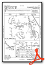
Instrument Approach Procedure (IAP) Charts
Nearby Airports with Instrument Procedures
| ID | Name | Heading / Distance | ||
|---|---|---|---|---|
 |
Y49 | Walker Municipal Airport | 150° | 24.2 |
|
KFSE | Fosston Municipal/Anderson Field Airport | 278° | 34.4 |
|
KPKD | Park Rapids Municipal/Konshok Field Airport | 188° | 37.0 |
|
3N8 | Mahnomen County Airport | 250° | 43.2 |
|
KXVG | Longville Municipal Airport | 136° | 43.2 |
|
KPWC | Pine River Regional Airport | 154° | 52.3 |
|
KFOZ | Bigfork Municipal Airport | 072° | 54.6 |
|
D14 | Fertile Municipal Airport | 273° | 55.2 |
|
KDTL | Detroit Lakes/Wething Field Airport | 223° | 56.7 |
|
KTVF | Thief River Falls Regional Airport | 303° | 60.6 |
|
16D | Perham Municipal Airport | 207° | 60.6 |
|
KGPZ | Grand Rapids/Itasca County-Gordon Newstrom Field Airport | 106° | 60.9 |