Login
Register


BKL
Burke Lakefront Airport
Official FAA Data Effective 2024-04-18 0901Z
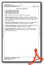
Chart Supplement

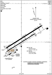
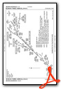
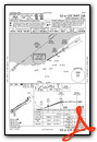
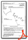
KBKL Airport Diagram
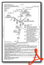
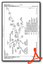
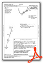
VFR Chart of KBKL
Sectional Charts at SkyVector.com
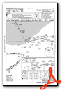
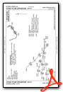
IFR Chart of KBKL
Enroute Charts at SkyVector.com
Location Information for KBKL
Coordinates: N41°31.07' / W81°40.96'Located 01 miles N of Cleveland, Ohio on 450 acres of land. View all Airports in Ohio.
Surveyed Elevation is 583 feet MSL.
Operations Data
|
|
Airport Communications
| ATIS: | 125.25 |
|---|---|
| ASOS: | Tel. 216-241-6904 |
| LAKEFRONT TOWER: | 124.3 339.8 |
| LAKEFRONT GROUND: | 121.9 339.8 |
| CLEVELAND APPROACH: | 125.35 346.325 |
| CLEVELAND DEPARTURE: | 125.35 346.325 |
| CLEARANCE DELIVERY: | 339.8 121.9 ;WHEN TWR CLSD |
| BRWNZ STAR: | 126.55 |
| CTAF: | 124.300 |
| TRYBE STAR: | 126.55 |
| ROKNN STAR: | 126.55 |
| ROLLN STAR: | 126.55 |
| UNICOM: | 122.950 |
| AWOS-3PT at CGF (9.2 E): | 216-289-4113 |
| D-ATIS at CGF (9.2 E): | 119.95 |
| D-ATIS at CLE (10.1 SW): | 127.85 ;ARR |
Nearby Navigation Aids
|
| ||||||||||||||||||||||||||||||||||||||||||||||||||||||||||||


Runway 06L/24R
| Dimensions: | 6604 x 150 feet / 2013 x 46 meters | |
|---|---|---|
| Surface: | Asphalt / Grooved in Good Condition | |
| Weight Limits: | 84 /F/C/X/T, S-93, D-113, ST-170 | |
| Edge Lighting: | High Intensity | |
| Runway 06L | Runway 24R | |
| Coordinates: | N41°30.85' / W81°41.52' | N41°31.43' / W81°40.30' |
| Elevation: | 581.1 | 582.4 |
| Traffic Pattern: | Left | Right |
| Runway Heading: | 58° True | 238° True |
| Displaced Threshold: | 178 Feet | 600 Feet |
| Declared Distances: | TORA:6503 TODA:6503 ASDA:6503 LDA:6325 | TORA:6603 TODA:6603 ASDA:6603 LDA:6003 |
| Markings: | Precision Instrument in good condition. | Precision Instrument in good condition. |
| Glide Slope Indicator | P4R (3.00° Glide Path Angle) UNUSBL BYD 5 DEGS RIGHT OF CNTRLN. | P4R (3.00° Glide Path Angle) UNUSBL BYD 8 DEGS LEFT OF CRS. |
| Approach Lights: | MALSF 1,400 Foot Medium-intensity Approach Lighting System with sequenced flashers. | |
| REIL: | Yes | |
| Obstacles: | RWY 06L/24R & RWY 06R/24L APCH SFCS HAVE NAVIGABLE WATERWAYS CREATING POSSIBLE VESSEL OBSTRUCTION AREAS - CHECK LOCAL NOTAMS FOR CURRENT ACTIVITY; VESSEL HEIGHT; ETC. |
122 ft Building 3364 ft from runway, 837 ft left of center |
Runway 06R/24L
CLSD TO UNSKED ACR OPS GTR THAN 30 PAX SEATS; CLSD WHEN ATCT CLSD. | ||
| Dimensions: | 5197 x 100 feet / 1584 x 30 meters | |
|---|---|---|
| Surface: | Asphalt / Grooved in Good Condition | |
| Weight Limits: | 63 /F/C/X/T, S-43, D-50, ST-82 | |
| Edge Lighting: | High Intensity | |
| Runway 06R | Runway 24L | |
| Coordinates: | N41°30.76' / W81°41.50' | N41°31.22' / W81°40.54' |
| Elevation: | 580.5 | 582.5 |
| Traffic Pattern: | Left | Right |
| Runway Heading: | 58° True | 238° True |
| Displaced Threshold: | 275 Feet | |
| Declared Distances: | TORA:5199 TODA:5199 ASDA:5199 LDA:4924 | TORA:5199 TODA:5199 ASDA:5199 LDA:5199 |
| Markings: | Basic in good condition. | Basic in good condition. |
| REIL: | Yes | |
| Obstacles: | 274 ft Antenna 6560 ft from runway, 1222 ft left of center | |
Services Available
| Fuel: | 100LL (blue), Jet-A |
|---|---|
| Transient Storage: | Hangars,Tiedowns |
| Airframe Repair: | MAJOR |
| Engine Repair: | MAJOR |
| Bottled Oxygen: | NONE |
| Bulk Oxygen: | HIGH/LOW |
| Other Services: | AIR FREIGHT SERVICES,AIR AMBULANCE SERVICES,AVIONICS,CARGO HANDLING SERVICES,CHARTER SERVICE,PILOT INSTRUCTION |
Ownership Information
| Ownership: | Publicly owned | |
|---|---|---|
| Owner: | CITY OF CLEVELAND | |
| 1501 N MARGINAL RD | ||
| CLEVELAND, OH 44114 | ||
| 216-781-6411 | ||
| Manager: | KHALID BAHHUR | |
| 1501 N MARGINAL RD | ||
| CLEVELAND, OH 44114 | ||
| 216-781-6411 | ||
Operational Statistics
| Single Engine Aircraft Based on Field: | 8 | Statistics collected for 12 month period ending 2022-12-31 | |
|---|---|---|---|
| Multi-Engine Aircraft Based on Field: | none | Annual Commercial Operations: | 97 |
| Jet Aircraft Based on Field: | 4 | Annual Commuter Operations: | none |
| Helicopters Based on Field: | 5 | Annual Air Taxi Operations: | 9682 |
| Military Aircraft Based on Field: | none | Annual Military Operations: | 449 |
| Gliders Based on Field: | none | Annual GA Local Operations: | 29391 |
| Ultralights Based on Field: | none | Annual GA Itinerant Operations: | 13258 |
Other Remarks
- BIRDS AND WATERFOWL ON & INVOF ARPT.
- FLIGHT NOTIFICATION SERVICE (ADCUS) AVBL 24 HRS MON-FRI REQ FOR SERVICE ON SAT; SUN & HOLS MUST BE MADE PRIOR TO 1630 ON FRI; 2 HRS ADVANCE NOTICE REQUIRED CALL 216-267-3600. PRIVATE ACFT & GENERAL AVIATION ONLY.
- 72 FT SHIP CRANE 1300 FT SW OF RWY 06R.
- FOR CD WHEN ATCT CLSD CTC CLEVELAND APCH AT 216-352-2323.
- WHEN ATCT CLSD ACTVT MALSF RWY 24R; REIL RWY 06L - CTAF. HIRL RWY 06L/24R PRESET MED INTST, TO INCR INTST RDO REQ ON UNICOM. PAPI RWY 06L & 24R OPR CONSLY.
Weather Minimums

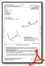
Standard Terminal Arrival (STAR) Charts
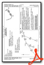
Instrument Approach Procedure (IAP) Charts
Departure Procedure (DP) Charts
Nearby Airports with Instrument Procedures
| ID | Name | Heading / Distance | ||
|---|---|---|---|---|
 |
KCGF | Cuyahoga County Airport | 072° | 9.2 |
|
KCLE | Cleveland-Hopkins International Airport | 230° | 10.1 |
|
KLNN | Lake County Exec Airport | 052° | 16.5 |
|
1G1 | Elyria Airport | 239° | 21.9 |
|
1G5 | Medina Municipal Airport | 189° | 23.5 |
|
KLPR | Lorain County Regional Airport | 245° | 24.6 |
|
1G3 | Kent State University Airport | 151° | 25.1 |
|
KPOV | Portage County Airport | 133° | 26.8 |
|
7G8 | Geauga County Airport | 098° | 28.2 |
|
KAKR | Akron Fulton International Airport | 161° | 30.4 |
|
3G3 | Wadsworth Municipal Airport | 186° | 31.1 |
|
KCAK | Akron-Canton Regional Airport | 163° | 37.7 |
Airport Images
Do you have a recent image of this airport? Upload it here!


