Login
Register


BKV
Brooksville-Tampa Bay Regional Airport
Official FAA Data Effective 2024-04-18 0901Z
Chart Supplement

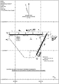
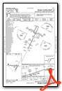
KBKV Airport Diagram
VFR Chart of KBKV
Sectional Charts at SkyVector.com
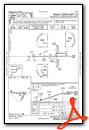
IFR Chart of KBKV
Enroute Charts at SkyVector.com
Location Information for KBKV
Coordinates: N28°28.42' / W82°27.33'Located 06 miles SW of Brooksville, Florida on 2402 acres of land. View all Airports in Florida.
Surveyed Elevation is 76 feet MSL.
Operations Data
|
|
Airport Communications
| ASOS: | 134.725 Tel. 352-799-5881 |
|---|---|
| BROOKSVILLE TOWER: | 118.55 |
| BROOKSVILLE GROUND: | 121.4 |
| TAMPA APPROACH: | 119.9 125.3 316.05 |
| TAMPA DEPARTURE: | 119.9 125.3 316.05 |
| CLEARANCE DELIVERY: | 119.125 ;WHEN TWR CLSD |
| ARNG OPS: | 42.525 |
| UNICOM: | 123.000 |
| CTAF: | 118.550 |
| AWOS-3 at INF (21.2 N): | 119.975 352-560-6012 |
| AWOS-3PT at ZPH (22.0 SE): | 118.975 813-780-0031 |
| AWOS-3 at CGC (24.5 N): | 118.325 352-563-6600 |
Nearby Navigation Aids
|
| ||||||||||||||||||||||||||||||||||||||||||


Runway 09/27
| Dimensions: | 7001 x 150 feet / 2134 x 46 meters | |
|---|---|---|
| Surface: | Asphalt / Grooved in Excellent Condition | |
| Weight Limits: | 29 /R/C/W/T, S-90, D-130, ST-230 | |
| Edge Lighting: | Medium Intensity | |
| Runway 09 | Runway 27 | |
| Coordinates: | N28°28.55' / W82°28.24' | N28°28.56' / W82°26.93' |
| Elevation: | 70.1 | 69.1 |
| Traffic Pattern: | Left | Left |
| Runway Heading: | 90° True | 270° True |
| Markings: | Precision Instrument in good condition. | Non-Precision Instrument in good condition. |
| Glide Slope Indicator | P4L (3.00° Glide Path Angle) | P4L (3.00° Glide Path Angle) |
| Approach Lights: | MALSR 1,400 Foot Medium-intensity Approach Lighting System with runway alignment indicator lights. | |
| Obstacles: | 70 ft Trees 3280 ft from runway, 360 ft right of center | 99 ft Trees 3540 ft from runway, 75 ft right of center |
Runway 03/21
| Dimensions: | 5014 x 150 feet / 1528 x 46 meters | |
|---|---|---|
| Surface: | Concrete in Good Condition | |
| Weight Limits: | 26 /R/C/W/T, S-50, D-75, ST-135 | |
| Edge Lighting: | Medium Intensity | |
| Runway 03 | Runway 21 | |
| Coordinates: | N28°27.85' / W82°27.17' | N28°28.59' / W82°26.76' |
| Elevation: | 67.5 | 68.0 |
| Traffic Pattern: | Left | Left |
| Runway Heading: | 26° True | 206° True |
| Markings: | Non-Precision Instrument in good condition. | Non-Precision Instrument in good condition. |
| Glide Slope Indicator | P4L (3.00° Glide Path Angle) | P4L (3.00° Glide Path Angle) |
| Obstacles: | 36 ft Trees 1095 ft from runway, 250 ft left of center | 81 ft Trees 2960 ft from runway |
Services Available
| Fuel: | 100LL (blue), Jet-A |
|---|---|
| Transient Storage: | Hangars,Tiedowns |
| Airframe Repair: | MAJOR |
| Engine Repair: | MAJOR |
| Bottled Oxygen: | LOW |
| Bulk Oxygen: | NOT AVAILABLE |
| Other Services: | AIR AMBULANCE SERVICES,AVIONICS,CHARTER SERVICE,GLIDER SERVICE,PILOT INSTRUCTION,AIRCRAFT RENTAL,AIRCRAFT SALES,ANNUAL SURVEYING,GLIDER TOWING SERVICES |
Ownership Information
| Ownership: | Publicly owned | |
|---|---|---|
| Owner: | HERNANDO COUNTY BOCC | |
| 20 NORTH MAIN STREET, ROOM 263, M 263 | ||
| BROOKSVILLE, FL 34601 | ||
| 352-754-4000 | ||
| Manager: | STEVE MILLER | |
| 15800 FLIGHT PATH DR | ||
| BROOKSVILLE, FL 34604 | ||
| 352-540-6342 | ||
Operational Statistics
| Single Engine Aircraft Based on Field: | 120 | Statistics collected for 12 month period ending 2017-12-15 | |
|---|---|---|---|
| Multi-Engine Aircraft Based on Field: | 24 | Annual Commercial Operations: | none |
| Jet Aircraft Based on Field: | 16 | Annual Commuter Operations: | none |
| Helicopters Based on Field: | 5 | Annual Air Taxi Operations: | 500 |
| Military Aircraft Based on Field: | 11 | Annual Military Operations: | 4500 |
| Gliders Based on Field: | 3 | Annual GA Local Operations: | 40000 |
| Ultralights Based on Field: | 2 | Annual GA Itinerant Operations: | 33000 |
Other Remarks
- WILDLIFE ON AND INVOF ARPT.
- FOR CD IF UNA TO CTC ON FSS FREQ, CTC TAMPA APCH AT 813-878-2528.
- PPR 352-797-5813. PRK RAMP 42.525.
- DUSK-2200. MALSR RWY 9; MIRL RWY 03/21 & 09/27 PRESET LOW INTST DUSK-2200, TO INCR INTST AND ACTVT AFTER 2200 - CTAF.
Weather Minimums


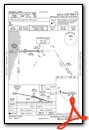
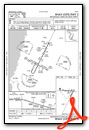
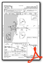
Instrument Approach Procedure (IAP) Charts
Nearby Airports with Instrument Procedures
| ID | Name | Heading / Distance | ||
|---|---|---|---|---|
 |
KINF | Inverness Airport | 020° | 21.0 |
|
KZPH | Zephyrhills Municipal Airport | 132° | 21.7 |
|
KCGC | Crystal River-Capt Tom Davis Field Airport | 345° | 24.4 |
|
KVDF | Tampa Exec Airport | 167° | 28.1 |
|
KTPA | Tampa International Airport | 187° | 30.1 |
|
KPCM | Plant City Airport | 151° | 32.3 |
|
KTPF | Peter O Knight Airport | 179° | 33.4 |
|
KCLW | Clearwater Air Park Airport | 208° | 33.8 |
|
X35 | Marion County Airport | 006° | 35.4 |
|
KPIE | St Pete-Clearwater International Airport | 199° | 36.0 |
|
KLAL | Lakeland Linder International Airport | 141° | 37.2 |
|
KMCF | Macdill AFB Airport | 185° | 37.5 |
Airport Images
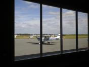
By: ULP11550


