Login
Register


BLH
Blythe Airport
Official FAA Data Effective 2024-04-18 0901Z
Chart Supplement

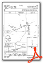
VFR Chart of KBLH
Sectional Charts at SkyVector.com
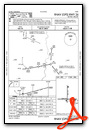
IFR Chart of KBLH
Enroute Charts at SkyVector.com
Location Information for KBLH
Coordinates: N33°37.15' / W114°43.01'Located 06 miles W of Blythe, California on 3904 acres of land. View all Airports in California.
Surveyed Elevation is 399 feet MSL.
Operations Data
|
|
Airport Communications
| ASOS: | 120.175 Tel. 760-922-3000 |
|---|---|
| CTAF: | 122.800 |
| UNICOM: | 122.800 |
| AWOS-3PT at P20 (38.9 NE): | 132.75 928-669-2160 |
| ATIS at LGF (48.1 S): | 128.225 |
| AWOS-3PT at LGF (48.7 S): |
- APCH/DEP CTL SVC PRVDD BY LOS ANGELES ARTCC (ZLA) ON FREQS 128.15/285.6 (LAGUNA RCAG).
Nearby Navigation Aids
|
| ||||||||||||||||||||||||||||||||||||

Runway 08/26
| Dimensions: | 6543 x 150 feet / 1994 x 46 meters | |
|---|---|---|
| Surface: | Asphalt in Fair Condition | |
| Weight Limits: | S-80, D-115, ST-210 | |
| Edge Lighting: | Medium Intensity | |
| Runway 08 | Runway 26 | |
| Coordinates: | N33°37.00' / W114°43.66' | N33°36.99' / W114°42.37' |
| Elevation: | 397.1 | 395.7 |
| Traffic Pattern: | Left | Left |
| Runway Heading: | 90° True | 270° True |
| Markings: | Basic in good condition. | Non-Precision Instrument in good condition. |
| Glide Slope Indicator | V4L (3.00° Glide Path Angle) | |
Runway 17/35
| Dimensions: | 5800 x 100 feet / 1768 x 30 meters | |
|---|---|---|
| Surface: | Asphalt in Fair Condition | |
| Weight Limits: | S-52, D-76, ST-135 | |
| Edge Lighting: | Medium Intensity | |
| Runway 17 | Runway 35 | |
| Coordinates: | N33°37.80' / W114°43.00' | N33°36.85' / W114°43.01' |
| Elevation: | 399.2 | 394.3 |
| Traffic Pattern: | Left | Left |
| Runway Heading: | 180° True | 0 |
| Markings: | Basic in fair condition. | Basic in fair condition. |
| Glide Slope Indicator | V4L (3.00° Glide Path Angle) | V4L (3.00° Glide Path Angle) |
Services Available
| Fuel: | 100LL (blue), Jet-A |
|---|---|
| Transient Storage: | Hangars,Tiedowns |
| Airframe Repair: | NONE |
| Engine Repair: | NONE |
| Bottled Oxygen: | NONE |
| Bulk Oxygen: | NONE |
| Other Services: | AIR AMBULANCE SERVICES,CARGO HANDLING SERVICES,PARACHUTE JUMP ACTIVITY |
Ownership Information
| Ownership: | Publicly owned | |
|---|---|---|
| Owner: | COUNTY OF RIVERSIDE | |
| 4080 LEMON STREET, 14TH FLOOR | ||
| RIVERSIDE, CA 90501 | ||
| 951-955-9418 | ||
| Manager: | ANGELA JAMISON | |
| 4080 LEMON STREET, 14TH FLOOR | ||
| RIVERSIDE, CA 92501 | ||
| 951-955-9418 | ||
Operational Statistics
| Single Engine Aircraft Based on Field: | 2 | Statistics collected for 12 month period ending 2024-01-31 | |
|---|---|---|---|
| Multi-Engine Aircraft Based on Field: | 1 | Annual Commercial Operations: | none |
| Jet Aircraft Based on Field: | none | Annual Commuter Operations: | none |
| Helicopters Based on Field: | none | Annual Air Taxi Operations: | none |
| Military Aircraft Based on Field: | none | Annual Military Operations: | 81 |
| Gliders Based on Field: | none | Annual GA Local Operations: | 6757 |
| Ultralights Based on Field: | none | Annual GA Itinerant Operations: | 6757 |
Other Remarks
- THIS AIRPORT HAS BEEN SURVEYED BY THE NATIONAL GEODETIC SURVEY.
- ACFT OVER 12500 LBS AVOID HOUSING AREA 1.5 NM SW BLO 2000' FINAL APCH RWY 35 BE ESTABD 2 NM FM TOUCHDOWN.
- DEP FM RY 17 MAKE CLIMBING LEFT TURN SOON AS SAFETY PERMITS. USE WIDE TFC PATTERN FOR RYS 26 & 35.
- POWER PLANT 1 MILE EAST OF ARPT PRODUCING THERMAL PLUMES; AVOID LOW ALTITUDE DIRECT OVERFLIGHT OF THE POWER PLANT.
- PAJA. PRCHT TRNG HIGH AND LOW LVLS ALL HRS NE QUAD OF ARPT
- FOR CD IF UNA TO CTC ON FSS FREQ, CTC LOS ANGELES ARTCC AT 661-575-2079.
- ACTVT VASI RWY 17, 35 & 26; MIRL RWY 17/35 & 08/26 - CTAF
Weather Minimums
Instrument Approach Procedure (IAP) Charts
Nearby Airports with Instrument Procedures
| ID | Name | Heading / Distance | ||
|---|---|---|---|---|
 |
P20 | Avi Suquilla Airport | 035° | 38.9 |
|
KCLR | Cliff Hatfield Memorial Airport | 234° | 49.9 |
|
KBWC | Brawley Municipal Airport | 227° | 55.0 |
|
KNYL | Yuma MCAS/Yuma International Airport | 174° | 57.9 |
|
KHII | Lake Havasu City Airport | 017° | 59.8 |
|
KTNP | Twentynine Palms Airport | 296° | 68.6 |
|
KEED | Needles Airport | 003° | 68.9 |
|
KTRM | Jacqueline Cochran Regional Airport | 270° | 72.3 |
|
KUDD | Bermuda Dunes Airport | 276° | 78.4 |
|
L08 | Borrego Valley Airport | 255° | 83.4 |
|
KPSP | Palm Springs International Airport | 278° | 90.5 |
|
KIFP | Laughlin/Bullhead International Airport | 004° | 92.3 |
Airport Images

By: patton aviation


