Login
Register


BMG
Monroe County Airport
Official FAA Data Effective 2024-04-18 0901Z
Chart Supplement

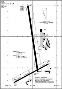
KBMG Airport Diagram
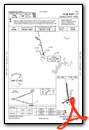
VFR Chart of KBMG
Sectional Charts at SkyVector.com
IFR Chart of KBMG
Enroute Charts at SkyVector.com
Location Information for KBMG
Coordinates: N39°8.76' / W86°37.00'Located 04 miles SW of Bloomington, Indiana on 1035 acres of land. View all Airports in Indiana.
Surveyed Elevation is 845 feet MSL.
Operations Data
|
|
Airport Communications
| ASOS: | 134.525 Tel. 812-825-8046 |
|---|---|
| BLOOMINGTON TOWER: | 120.775 |
| BLOOMINGTON GROUND: | 121.9 |
| HULMAN APPROACH: | 128.025 339.8 |
| HULMAN DEPARTURE: | 128.025 339.8 |
| UNICOM: | 122.950 |
| CTAF: | 120.775 |
| EMERG: | 121.5 |
| AWOS-3 at BFR (20.0 SE): | 119.125 812-275-8306 |
| AWOS-3 at HBE (29.7 NE): | 119.675 812-526-1745 |
| AWOS-3PT at GPC (30.8 N): | 118.125 765-653-1789 |
Nearby Navigation Aids
|
| ||||||||||||||||||||||||||||||||||||||||||||||||||||||||||||


Runway 17/35
| Dimensions: | 6500 x 150 feet / 1981 x 46 meters | |
|---|---|---|
| Surface: | Asphalt / Grooved in Good Condition | |
| Weight Limits: | 31 /F/D/X/U, S-68, D-121, ST-169 | |
| Edge Lighting: | High Intensity | |
| Runway 17 | Runway 35 | |
| Coordinates: | N39°9.49' / W86°37.09' | N39°8.43' / W86°36.89' |
| Elevation: | 845.5 | 837.4 |
| Traffic Pattern: | Left | Left |
| Runway Heading: | 172° True | 352° True |
| Markings: | Non-Precision Instrument in good condition. | Precision Instrument in good condition. |
| Glide Slope Indicator | P4L (3.00° Glide Path Angle) | |
| Approach Lights: | MALSR 1,400 Foot Medium-intensity Approach Lighting System with runway alignment indicator lights. | |
| REIL: | Yes | |
| Obstacles: | 60 ft Tree 2600 ft from runway, 1100 ft right of center | |
Runway 06/24
UNSKED ACR WITH AT LEAST 31 PAX SEATS NA. | ||
| Dimensions: | 3798 x 100 feet / 1158 x 30 meters | |
|---|---|---|
| Surface: | Asphalt / Grooved in Fair Condition | |
| Weight Limits: | 4 /F/D/X/U, S-35, D-50 | |
| Edge Lighting: | Medium Intensity | |
| Runway 06 | Runway 24 | |
| Coordinates: | N39°8.27' / W86°37.38' | N39°8.57' / W86°36.67' |
| Elevation: | 832.3 | 840.7 |
| Traffic Pattern: | Left | Left |
| Runway Heading: | 62° True | 242° True |
| Displaced Threshold: | 304 Feet | 222 Feet |
| Markings: | Non-Precision Instrument in good condition. | Non-Precision Instrument in good condition. |
| Glide Slope Indicator | P4L (4.00° Glide Path Angle) | |
| Obstacles: | 22 ft Road 200 ft from runway, 204 ft right of center APCH RATIO 19:1 TO DTHR; 64 FT TREES 950 FT FM RWY 210 FT R. ROAD 100-200 FT FM THR 200-250 FT R. |
18 ft Road 200 ft from runway, 100 ft left of center APCH RATIO 12:1; 19 FT ROAD 245 FT FM DTHR 250 FT L. 7 FT FENCE 175 FT FM THR 113 FT L OF RWY EXTDD CTRLN. |
Services Available
| Fuel: | 100LL (blue), Jet-A |
|---|---|
| Transient Storage: | Hangars,Tiedowns |
| Airframe Repair: | MAJOR |
| Engine Repair: | MAJOR |
| Bottled Oxygen: | HIGH/LOW |
| Bulk Oxygen: | NOT AVAILABLE |
Ownership Information
| Ownership: | Publicly owned | |
|---|---|---|
| Owner: | MONROE COUNTY | |
| 972 SOUTH KIRBY ROAD | ||
| BLOOMINGTON, IN 47403 | ||
| 812-825-5406 | ||
| Manager: | CARLOS LAVERTY | |
| 972 S. KIRBY RD | ||
| BLOOMINGTON, IN 47403 | ||
| 812-825-5406 | ||
Operational Statistics
| Single Engine Aircraft Based on Field: | 89 | Statistics collected for 12 month period ending 2021-12-31 | |
|---|---|---|---|
| Multi-Engine Aircraft Based on Field: | 10 | Annual Commercial Operations: | 62 |
| Jet Aircraft Based on Field: | 5 | Annual Commuter Operations: | none |
| Helicopters Based on Field: | 1 | Annual Air Taxi Operations: | 1323 |
| Military Aircraft Based on Field: | none | Annual Military Operations: | 191 |
| Gliders Based on Field: | 1 | Annual GA Local Operations: | 13358 |
| Ultralights Based on Field: | none | Annual GA Itinerant Operations: | 14442 |
Other Remarks
- SFC COND UNMNT MON-FRI 1600-0800 & WKEND.
- FOR CD CTC HULMAN APCH AT 812-877-7581.
- WHEN ATCT CLSD ACTVT MALSR RWY 35; REIL RWY 17; PAPI RWY 24; MIRL RWY 06/24; HIRL RWY 17/35 - CTAF. PAPI RWY 17 ON CONSLY.
Weather Minimums

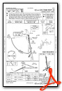
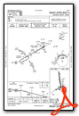
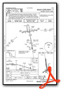
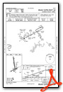
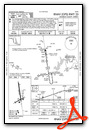
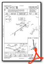
Instrument Approach Procedure (IAP) Charts
Nearby Airports with Instrument Procedures
| ID | Name | Heading / Distance | ||
|---|---|---|---|---|
 |
KBFR | Virgil I Grissom Municipal Airport | 156° | 20.0 |
|
0I2 | Brazil Clay County Airport | 311° | 30.0 |
|
KGPC | Putnam County Regional Airport | 342° | 30.6 |
|
KBAK | Columbus Municipal Airport | 078° | 34.3 |
|
KSER | Freeman Municipal Airport | 111° | 35.6 |
|
KDCY | Daviess County Airport | 222° | 36.0 |
|
2R2 | Hendricks County-Gordon Graham Field Airport | 010° | 36.6 |
|
KHUF | Terre Haute Regional Airport | 299° | 37.0 |
|
KIND | Indianapolis International Airport | 023° | 37.4 |
|
KHFY | Indy South Greenwood Airport | 040° | 37.9 |
|
KFRH | French Lick Municipal Airport | 181° | 38.4 |
|
KSIV | Sullivan County Airport | 267° | 38.9 |
Fuel Providers

Airport Images
 from E, 3500'")
By: 2flaps
 from ENE")
By: 2flaps


