Login
Register


BOW
Bartow Exec Airport
Official FAA Data Effective 2024-04-18 0901Z
Chart Supplement

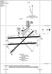
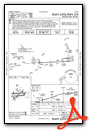
KBOW Airport Diagram
VFR Chart of KBOW
Sectional Charts at SkyVector.com
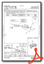
IFR Chart of KBOW
Enroute Charts at SkyVector.com
Location Information for KBOW
Coordinates: N27°56.60' / W81°47.01'Located 04 miles NE of Bartow, Florida on 1846 acres of land. View all Airports in Florida.
Surveyed Elevation is 124 feet MSL.
Operations Data
|
|
Airport Communications
| AWOS-3: | 123.775 Tel. 863-533-9004 |
|---|---|
| BARTOW TOWER: | 121.2 121.5R |
| BARTOW GROUND: | 121.9 |
| TAMPA APPROACH: | 119.9 120.65 290.3 |
| TAMPA DEPARTURE: | 119.9 120.65 290.3 |
| UNICOM: | 122.950 |
| EMERG: | 121.5 |
| CTAF: | 121.200 |
| ASOS at GIF (7.2 N): | 133.675 863-956-2097 |
| AWOS-3 at X07 (9.3 E): | 124.225 863-678-1334 |
| ATIS at LAL (12.8 W): | 118.025 |
- ATCT CLSD EASTER; THANKSGIVING; CHRISTMAS; & OTHER HOLS BY NOTAM.
Nearby Navigation Aids
|
| ||||||||||||||||||||||||||||||||||||||||||


Runway 05/23
| Dimensions: | 5001 x 100 feet / 1524 x 30 meters | |
|---|---|---|
| Surface: | Asphalt in Poor Condition CRACKING THRUT RWY 05/23. | |
| Weight Limits: | 27 /F/A/X/T, S-35, D-60, ST-110 | |
| Edge Lighting: | Medium Intensity | |
| Runway 05 | Runway 23 | |
| Coordinates: | N27°56.29' / W81°47.36' | N27°56.86' / W81°46.69' |
| Elevation: | 107.9 | 122.2 |
| Traffic Pattern: | Left | Left |
| Runway Heading: | 46° True | 226° True |
| Markings: | Non-Precision Instrument in good condition. | Non-Precision Instrument in good condition. |
| Glide Slope Indicator | P4L (3.50° Glide Path Angle) | P4L (3.50° Glide Path Angle) |
| REIL: | Yes | Yes |
| Obstacles: | 33 ft Trees 1380 ft from runway, 250 ft left of center | 45 ft Trees 1620 ft from runway, 250 ft left of center |
Runway 09L/27R
| Dimensions: | 5000 x 150 feet / 1524 x 46 meters | |
|---|---|---|
| Surface: | Asphalt in Good Condition | |
| Weight Limits: | 48 /F/A/W/T | |
| Edge Lighting: | Medium Intensity | |
| Runway 09L | Runway 27R | |
| Coordinates: | N27°56.67' / W81°47.44' | N27°56.72' / W81°46.51' |
| Elevation: | 116.9 | 114.5 |
| Runway Heading: | 87° True | 267° True |
| Markings: | Non-Precision Instrument in good condition. | Non-Precision Instrument in good condition. |
| Glide Slope Indicator | P4L (3.00° Glide Path Angle) | P4L (3.00° Glide Path Angle) |
| REIL: | Yes | Yes |
| Obstacles: | 62 ft Tree 2290 ft from runway, 110 ft right of center | 28 ft Tree 1130 ft from runway, 240 ft left of center |
Runway 09R/27L
| Dimensions: | 4416 x 150 feet / 1346 x 46 meters | |
|---|---|---|
| Surface: | Asphalt-Concrete in Poor Condition 1 RWY 27L CONC 1ST 300 FT. RWY 09R/27L PRODUCING LOOSE AGGREGATE IN SOME AREAS. | |
| Weight Limits: | 6 /F/A/Y/T | |
| Runway 09R | Runway 27L | |
| Coordinates: | N27°56.51' / W81°47.43' | N27°56.55' / W81°46.61' |
| Elevation: | 112.3 | 111.6 |
| Traffic Pattern: | Left | Left |
| Runway Heading: | 87° True | 267° True |
| Markings: | Basic in good condition. | Basic in good condition. |
| Obstacles: | 56 ft Trees 1900 ft from runway, 175 ft left of center | 40 ft Trees 1000 ft from runway, 30 ft right of center |
Services Available
| Fuel: | 100LL (blue), Jet-A |
|---|---|
| Transient Storage: | Hangars,Tiedowns |
| Airframe Repair: | MAJOR |
| Engine Repair: | MAJOR |
| Bottled Oxygen: | NONE |
| Bulk Oxygen: | NONE |
| Other Services: | AIR AMBULANCE SERVICES,AVIONICS,PILOT INSTRUCTION,AIRCRAFT RENTAL,AIRCRAFT SALES,ANNUAL SURVEYING |
Ownership Information
| Ownership: | Publicly owned | |
|---|---|---|
| Owner: | BARTOW MUNI ARPT DVLPMNT AUTH | |
| PO BOX 650 | ||
| BARTOW, FL 33831-0650 | ||
| 863-533-1195 | ||
| Manager: | JOHN B. HELMS, II | |
| 5993 AIRPORT BLVD | ||
| BARTOW, FL 33830 | ||
| 863-533-1195 | ||
Operational Statistics
| Single Engine Aircraft Based on Field: | 109 | Statistics collected for 12 month period ending 2023-11-29 | |
|---|---|---|---|
| Multi-Engine Aircraft Based on Field: | 13 | Annual Commercial Operations: | none |
| Jet Aircraft Based on Field: | 4 | Annual Commuter Operations: | none |
| Helicopters Based on Field: | 8 | Annual Air Taxi Operations: | 1515 |
| Military Aircraft Based on Field: | none | Annual Military Operations: | 57 |
| Gliders Based on Field: | 1 | Annual GA Local Operations: | 20207 |
| Ultralights Based on Field: | none | Annual GA Itinerant Operations: | 42253 |
Other Remarks
- OVERHEAD PLINES IN T-HANGAR AREA - APPROX 20' VERTICAL CLEARANCE.
- WILDLIFE INVOF ARPT.
- WHEN ATCT CLSD, FOR CD CTC TAMPA APCH AT 813-878-2528
- 0LL 100LL AVBL 24 HRS WITH CREDIT CARD.
- ACTVT REILS RWY 05, 09L, 23 & 27R; PAPI RWYS 05, 09L, 23, & 27R; MIRL RWYS 05/23 & 09L/27R; AND WIND CONE - CTAF. REIL RWYS 05, 09L, 23 & 27R OPER WHEN MIRL RWYS 05/23 & 09L/27R HIGH INTST ONLY.
Weather Minimums


Instrument Approach Procedure (IAP) Charts
Nearby Airports with Instrument Procedures
| ID | Name | Heading / Distance | ||
|---|---|---|---|---|
 |
KGIF | Winter Haven Regional Airport | 012° | 7.3 |
|
X07 | Lake Wales Municipal Airport | 109° | 9.1 |
|
KLAL | Lakeland Linder International Airport | 282° | 12.8 |
|
KPCM | Plant City Airport | 279° | 20.5 |
|
KAVO | Avon Park Exec Airport | 147° | 25.0 |
|
KZPH | Zephyrhills Municipal Airport | 310° | 26.0 |
|
KCHN | Wauchula Municipal Airport | 191° | 26.2 |
|
KISM | Kissimmee Gateway Airport | 041° | 27.7 |
|
KVDF | Tampa Exec Airport | 278° | 30.1 |
|
KTPF | Peter O Knight Airport | 267° | 35.4 |
|
KSEF | Sebring Regional Airport | 141° | 37.4 |
|
KMCO | Orlando International Airport | 040° | 38.5 |
Airport Images

By: chabrier


