Login
Register


BST
Belfast Municipal Airport
Official FAA Data Effective 2024-04-18 0901Z
Chart Supplement

VFR Chart of KBST
Sectional Charts at SkyVector.com
IFR Chart of KBST
Enroute Charts at SkyVector.com
Location Information for KBST
Coordinates: N44°24.56' / W69°0.71'Located 01 miles SW of Belfast, Maine on 218 acres of land. View all Airports in Maine.
Surveyed Elevation is 197 feet MSL.
Operations Data
|
|
Airport Communications
| AWOS-AV: | 122.975 Tel. 207-930-7071 |
|---|---|
| BANGOR APPROACH: | 118.925 239.3 |
| BANGOR DEPARTURE: | 118.925 239.3 |
| UNICOM: | 122.975 |
| CTAF: | 122.975 |
| AWOS-3PT at RKD (21.3 S): | 119.025 207-594-7946 |
| ATIS at BGR (25.2 N): | 127.75 |
| ASOS at BGR (25.2 N): | 127.75 207-561-2515 |
Nearby Navigation Aids
|
| ||||||||||||||||||||||||||||||||||||||||||||||||||||||


Runway 15/33
| Dimensions: | 4000 x 100 feet / 1219 x 30 meters | |
|---|---|---|
| Surface: | Asphalt in Good Condition | |
| Weight Limits: | S-30 | |
| Edge Lighting: | Medium Intensity | |
| Runway 15 | Runway 33 | |
| Coordinates: | N44°24.79' / W69°1.04' | N44°24.34' / W69°0.38' |
| Elevation: | 197.5 | 158.5 |
| Traffic Pattern: | Left | Left |
| Runway Heading: | 133° True | 313° True |
| Markings: | Non-Precision Instrument in good condition. | Non-Precision Instrument in good condition. |
| REIL: | Yes | Yes |
| Obstacles: | 10 ft Tree 213 ft from runway, 150 ft left of center 8 FT BRUSH 140-200 FT FM THR, 75-250 FT R OF CNTRLN; 4-10 FT BRUSH 60-200 FT FM THR, 200-250 FT L OF CNTRLN. |
18 ft Tree 330 ft from runway, 220 ft right of center 80 FT TALL OBSTN LGTS ALG BOTH SIDES OF PRI SFC AT EDGE OF TREE LINE. 4-8 FT BRUSH 30-200 FT FM THR, 90-200 FT R OF CNTRLN. |
Services Available
| Fuel: | 100LL (blue), Jet A+ |
|---|---|
| Transient Storage: | Hangars,Tiedowns CALL AHD FOR AVBLTY. |
| Airframe Repair: | NONE |
| Engine Repair: | NONE |
| Bottled Oxygen: | NONE |
| Bulk Oxygen: | NONE |
| Other Services: | CHARTER SERVICE,PILOT INSTRUCTION |
Ownership Information
| Ownership: | Publicly owned | |
|---|---|---|
| Owner: | CITY OF BELFAST | |
| CITY HALL, 131 CHURCH ST | ||
| BELFAST, ME 04915 | ||
| 207-338-3370X600 | ||
| Manager: | KENN ORTMANN | |
| 22 WRIGHT BROTHERS DR, C/O 131 CHURCH STREET | SEND ALL MGR CORRESPONDANCE TO CITY HALL 131 CHURCH ST. BELFAST, ME 04915. | |
| BELFAST, ME 04915 | ||
| 603-970-1947 | ||
Operational Statistics
| Single Engine Aircraft Based on Field: | 27 | Statistics collected for 12 month period ending 2023-12-31 | |
|---|---|---|---|
| Multi-Engine Aircraft Based on Field: | none | Annual Commercial Operations: | none |
| Jet Aircraft Based on Field: | none | Annual Commuter Operations: | none |
| Helicopters Based on Field: | none | Annual Air Taxi Operations: | 500 |
| Military Aircraft Based on Field: | none | Annual Military Operations: | none |
| Gliders Based on Field: | none | Annual GA Local Operations: | 2000 |
| Ultralights Based on Field: | none | Annual GA Itinerant Operations: | 700 |
Other Remarks
- FOR CD CTC BANGOR APCH AT 207-561-2500 EXT 1.
- 800 FT X 30 FT PARL TURF LDG AREA E OF RWY & N OF TWY B - AMGR.
- FAA WX CAMERA INFO AVBL AT HTTPS://WEATHERCAMS.FAA.GOV/MAP/-69.61024,44.01514,-67.21384,44.80289/CAMERASITE/600/DETAILS/CAMERA.
- COURTSEY VEHICLE AVBL. ADVN REQ 603-970-1947.
- AWOS AVBL - CTAF 2 CLICKS OR 207-930-7071.
- DEER & BIRDS ON & INVOF ARPT.
- SFC COND RPRTD DAILY 1400-2200Z DEC-MAR.
- ACTVT REIL RWY 15 & 33; MIRL RWY 15/33 - CTAF.
Weather Minimums
Instrument Approach Procedure (IAP) Charts
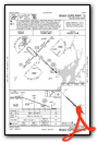
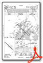
Nearby Airports with Instrument Procedures
| ID | Name | Heading / Distance | ||
|---|---|---|---|---|
 |
KRKD | Knox County Regional Airport | 190° | 21.3 |
|
KBGR | Bangor International Airport | 018° | 25.1 |
|
2B7 | Pittsfield Municipal Airport | 324° | 26.6 |
|
KBHB | Hancock County/Bar Harbor Airport | 084° | 28.1 |
|
KWVL | Waterville Robert Lafleur Airport | 284° | 29.5 |
|
KAUG | Augusta State Airport | 261° | 34.2 |
|
KOLD | Dewitt Field/Old Town Municipal Airport | 023° | 35.6 |
|
1B0 | Dexter Regional Airport | 344° | 37.0 |
|
KIWI | Wiscasset Airport | 228° | 40.5 |
|
KOWK | Central Maine/Norridgewock Airport | 296° | 41.0 |
|
43B | Deblois Flight Strip Airport | 066° | 47.7 |
|
KBXM | Brunswick Exec Airport | 232° | 50.7 |
Airport Images

By: Belfast Airport


