Login
Register


BVX
Batesville Regional Airport
Official FAA Data Effective 2024-04-18 0901Z
Chart Supplement

VFR Chart of KBVX
Sectional Charts at SkyVector.com
IFR Chart of KBVX
Enroute Charts at SkyVector.com
Location Information for KBVX
Coordinates: N35°43.57' / W91°38.85'Located 03 miles S of Batesville, Arkansas on 398 acres of land. View all Airports in Arkansas.
Surveyed Elevation is 465 feet MSL.
Operations Data
|
|
Airport Communications
| AWOS-3PT: | 126.375 Tel. 870-251-1369 |
|---|---|
| UNICOM: | 122.800 |
| CTAF: | 122.800 |
| AWOS-3PT at 42A (22.5 N): | 121.575 870-916-2768 |
| AWOS-3PT at M19 (23.6 E): | 118.15 870-523-2189 |
| AWOS-3PT at SRC (31.3 S): | 128.325 501-268-4280 |
- APCH/DEP SVC PRVDD BY MEMPHIS ARTCC ON FREQS 126.85/281.55 (BRINKLEY RCAG).
Nearby Navigation Aids
|
| ||||||||||||||||||||||||||||||||||||||||||||||||||||||||||||


Runway 08/26
| Dimensions: | 6002 x 150 feet / 1829 x 46 meters | |
|---|---|---|
| Surface: | Asphalt in Fair Condition | |
| Weight Limits: | S-35, D-50, ST-80 | |
| Edge Lighting: | Medium Intensity | |
| Runway 08 | Runway 26 | |
| Coordinates: | N35°43.38' / W91°39.67' | N35°43.56' / W91°38.47' |
| Elevation: | 452.2 | 464.6 |
| Traffic Pattern: | Left | Left |
| Runway Heading: | 80° True | 260° True |
| Markings: | Non-Precision Instrument in good condition. | Non-Precision Instrument in good condition. |
| Glide Slope Indicator | P2L (3.00° Glide Path Angle) | P2L (3.00° Glide Path Angle) |
| REIL: | Yes | Yes |
| Obstacles: | 32 ft Tree 1320 ft from runway | |
Runway 18/36
| Dimensions: | 2804 x 60 feet / 855 x 18 meters | |
|---|---|---|
| Surface: | Asphalt in Good Condition | |
| Weight Limits: | S-8 | |
| Runway 18 | Runway 36 | |
| Coordinates: | N35°44.02' / W91°38.36' | N35°43.56' / W91°38.37' |
| Elevation: | 435.4 | 460.4 |
| Traffic Pattern: | Left | Left |
| Runway Heading: | 181° True | 1° True |
| Markings: | Basic in good condition. | Basic in good condition. |
| Obstacles: | 45 ft Tree 800 ft from runway, 180 ft right of center | 10 ft Road 275 ft from runway |
Services Available
| Fuel: | 100LL (blue), Jet A+ |
|---|---|
| Transient Storage: | Hangars,Tiedowns |
| Airframe Repair: | MAJOR |
| Engine Repair: | MAJOR |
| Bottled Oxygen: | NONE |
| Bulk Oxygen: | NONE |
| Other Services: | AIR AMBULANCE SERVICES,PILOT INSTRUCTION,AIRCRAFT RENTAL |
Ownership Information
| Ownership: | Publicly owned | |
|---|---|---|
| Owner: | CITY OF BATESVILLE | |
| 500 EAST MAIN ST. | ||
| BATESVILLE, AR 72501 | ||
| 870-698-2400 | ||
| Manager: | JUSTIN THOMPSON | |
| 1126 BATESVILLE BLVD | ||
| BATESVILLE, AR 72501 | ||
| 870-251-1244 | ||
Operational Statistics
| Single Engine Aircraft Based on Field: | 39 | Statistics collected for 12 month period ending 2023-09-30 | |
|---|---|---|---|
| Multi-Engine Aircraft Based on Field: | 5 | Annual Commercial Operations: | none |
| Jet Aircraft Based on Field: | 1 | Annual Commuter Operations: | none |
| Helicopters Based on Field: | 5 | Annual Air Taxi Operations: | 850 |
| Military Aircraft Based on Field: | none | Annual Military Operations: | 200 |
| Gliders Based on Field: | none | Annual GA Local Operations: | 6000 |
| Ultralights Based on Field: | 2 | Annual GA Itinerant Operations: | 10000 |
Other Remarks
- THIS AIRPORT HAS BEEN SURVEYED BY THE NATIONAL GEODETIC SURVEY.
- FOR CD CTC MEMPHIS ARTCC AT 901-368-8453/8449.
- 0LL 100LL SELF SVC AVBL WITH CREDIT CARD. FOR SVC AFTER HRS CALL 870-251-1244, FEE CHRGD.
- ACTVT REIL RWYS 08 & 26 AND MIRL RWY 08/26 - CTAF.
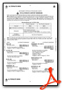
Weather Minimums

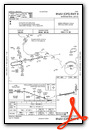
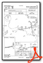
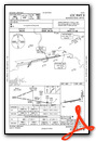
Instrument Approach Procedure (IAP) Charts
Nearby Airports with Instrument Procedures
| ID | Name | Heading / Distance | ||
|---|---|---|---|---|
 |
KHBZ | Heber Springs Municipal Airport | 234° | 22.0 |
|
42A | Melbourne Municipal - John E Miller Field Airport | 336° | 22.5 |
|
7M2 | Mountain View Wilcox Memorial Field Airport | 291° | 23.2 |
|
M19 | Newport Regional Airport | 102° | 23.6 |
|
6M2 | Horseshoe Bend Airport | 349° | 30.1 |
|
KSRC | Searcy Regional Airport | 188° | 31.2 |
|
KCVK | Sharp County Regional Airport | 007° | 32.5 |
|
M60 | Woodruff County Airport | 145° | 32.9 |
|
2A2 | Holley Mountain Airpark Airport | 263° | 37.2 |
|
KCCA | Clinton Municipal Airport | 259° | 40.1 |
|
KARG | Walnut Ridge Regional Airport | 055° | 42.5 |
|
M70 | Pocahontas Municipal Airport | 047° | 45.9 |
Airport Images
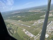
By: Big Orange Bird
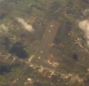
By: Dave


