Login
Register


BWG
Bowling Green-Warren County Regional Airport
Official FAA Data Effective 2024-04-18 0901Z
Chart Supplement

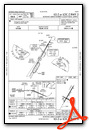
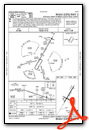
VFR Chart of KBWG
Sectional Charts at SkyVector.com
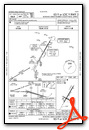
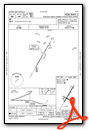
IFR Chart of KBWG
Enroute Charts at SkyVector.com
Location Information for KBWG
Coordinates: N36°57.87' / W86°25.18'Located 02 miles SE of Bowling Green, Kentucky on 566 acres of land. View all Airports in Kentucky.
Surveyed Elevation is 547 feet MSL.
Operations Data
|
|
Airport Communications
| ASOS: | 127.825 Tel. 270-843-8136 |
|---|---|
| CTAF: | 123.000 |
| UNICOM: | 123.000 |
| AWOS-3PT at 1M5 (22.3 S): | 118.175 615-325-4971 |
| AWOS-3 at GLW (22.8 E): | 118.525 270-678-5787 |
| AWOS-3 at M91 (35.2 SW): | 120.675 615-384-8206 |
- APCH/DEP SVC PRVDD BY MEMPHIS ARTCC ON FREQS 133.85/317.6 (NASHVILLE RCAG).
- COMMUNICATIONS PRVDD BY LOUISVILLE RADIO ON FREQ 122.4 (BOWLING GREEN RCO).
Nearby Navigation Aids
|
| ||||||||||||||||||||||||||||||||||||||||||||||||||||||||||||


Runway 03/21
| Dimensions: | 6501 x 150 feet / 1982 x 46 meters | |
|---|---|---|
| Surface: | Asphalt in Good Condition | |
| Weight Limits: | 63 /F/C/X/T, S-120, D-221, ST-358 | |
| Edge Lighting: | High Intensity | |
| Runway 03 | Runway 21 | |
| Coordinates: | N36°57.52' / W86°25.50' | N36°58.45' / W86°24.84' |
| Elevation: | 547.1 | 520.4 |
| Traffic Pattern: | Left | Left |
| Runway Heading: | 30° True | 210° True |
| Markings: | Precision Instrument in fair condition. | Non-Precision Instrument in fair condition. |
| Glide Slope Indicator | P4L (3.00° Glide Path Angle) | P4L (3.00° Glide Path Angle) |
| REIL: | Yes | Yes |
Runway 12/30
NOT AVBL FOR SKED ACR OPS MORE THAN 9 PAX SEATS OR UNSKED ACR AT LEAST 31 PAX SEATS. | ||
| Dimensions: | 3956 x 150 feet / 1206 x 46 meters | |
|---|---|---|
| Surface: | Asphalt in Poor Condition LONGITUDINAL AND TRANSVERSE CRACKING; UNEVEN SURFACE | |
| Weight Limits: | 9 /F/C/X/T, S-25, D-40 | |
| Edge Lighting: | Medium Intensity | |
| Runway 12 | Runway 30 | |
| Coordinates: | N36°57.84' / W86°25.55' | N36°57.52' / W86°24.85' |
| Elevation: | 530.9 | 531.2 |
| Traffic Pattern: | Left | Left |
| Runway Heading: | 120° True | 300° True |
| Displaced Threshold: | 349 Feet | |
| Markings: | Basic in good condition. | Basic in good condition. |
Services Available
| Fuel: | 100LL (blue), Jet-A |
|---|---|
| Transient Storage: | Hangars,Tiedowns |
| Airframe Repair: | MAJOR |
| Engine Repair: | MAJOR |
| Bottled Oxygen: | NOT AVAILABLE |
| Bulk Oxygen: | NOT AVAILABLE |
| Other Services: | AIR FREIGHT SERVICES,AIR AMBULANCE SERVICES,CARGO HANDLING SERVICES,CHARTER SERVICE,PILOT INSTRUCTION,AIRCRAFT RENTAL,AIRCRAFT SALES |
Ownership Information
| Ownership: | Publicly owned | |
|---|---|---|
| Owner: | CITY BOWLING GREEN-WARREN CO | |
| 1000 WOODHURST ST | ||
| BOWLING GREEN, KY 42103 | ||
| 270-842-1101 | ||
| Manager: | SUSAN HARMON | |
| 1000 WOODHURST ST | ||
| BOWLING GREEN, KY 42103 | ||
| 270-842-1101 | ||
Operational Statistics
| Single Engine Aircraft Based on Field: | 54 | Statistics collected for 12 month period ending 2022-12-31 | |
|---|---|---|---|
| Multi-Engine Aircraft Based on Field: | 9 | Annual Commercial Operations: | 12 |
| Jet Aircraft Based on Field: | 5 | Annual Commuter Operations: | none |
| Helicopters Based on Field: | 2 | Annual Air Taxi Operations: | 1390 |
| Military Aircraft Based on Field: | none | Annual Military Operations: | 50 |
| Gliders Based on Field: | none | Annual GA Local Operations: | 5246 |
| Ultralights Based on Field: | none | Annual GA Itinerant Operations: | 3116 |
Other Remarks
- BIRDS ON & INVOF ARPT.
- CNL IFR - LOUISVILLE FSS 122.2.
- FOR CD CTC MEMPHIS ARTCC AT 901-368-8453/8449.
- ACTVT REIL RWY 03 & 21; HIRL RWY 03/21 - CTAF.
Weather Minimums
Instrument Approach Procedure (IAP) Charts
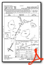
Nearby Airports with Instrument Procedures
| ID | Name | Heading / Distance | ||
|---|---|---|---|---|
 |
4M7 | Russellville-Logan County Airport | 242° | 21.3 |
|
1M5 | Douglas Hunter Field Airport | 187° | 22.4 |
|
KGLW | Glasgow Municipal Airport | 079° | 22.8 |
|
M20 | Leitchfield-Grayson County Airport | 016° | 27.2 |
|
3M7 | Lafayette Municipal Airport | 146° | 31.8 |
|
M91 | Springfield Robertson County Airport | 223° | 35.2 |
|
KXNX | Music City Exec Airport | 179° | 35.3 |
|
KJQD | Ohio County Airport | 325° | 36.1 |
|
M21 | Muhlenberg County Airport | 294° | 38.7 |
|
KTZV | Tompkinsville/Monroe County Airport | 110° | 39.6 |
|
M54 | Lebanon Municipal Airport | 173° | 46.7 |
|
I93 | Breckinridge County Airport | 358° | 49.2 |
Airport Images
Do you have a recent image of this airport? Upload it here!


