Login
Register


CCA
Clinton Municipal Airport
Official FAA Data Effective 2024-04-18 0901Z
Chart Supplement

VFR Chart of KCCA
Sectional Charts at SkyVector.com
IFR Chart of KCCA
Enroute Charts at SkyVector.com
Location Information for KCCA
Coordinates: N35°35.86' / W92°27.09'Located 01 miles NE of Clinton, Arkansas on 55 acres of land. View all Airports in Arkansas.
Surveyed Elevation is 513 feet MSL.
Operations Data
|
|
Airport Communications
| AWOS-3: | 118.725 Tel. 501-745-5000 |
|---|---|
| UNICOM: | 122.700 |
| CTAF: | 122.700 |
| AWOS-2 at CXW (35.0 S): | 118.775 501-358-6209 |
| ASOS at RUE (37.4 SW): | 132.475 479-968-2267 |
| AWOS-3PT at BVX (40.0 E): | 126.375 870-251-1369 |
- APCH/DEP SVC PRVDD BY MEMPHIS ARTCC (ZME) ON 126.850/281.550 (HARRISON RCAG).
Nearby Navigation Aids
|
| ||||||||||||||||||||||||||||||||||||||||||||||||||||||||||||


Runway 13/31
| Dimensions: | 4007 x 60 feet / 1221 x 18 meters | |
|---|---|---|
| Surface: | Asphalt in Good Condition | |
| Edge Lighting: | Medium Intensity | |
| Runway 13 | Runway 31 | |
| Coordinates: | N35°36.09' / W92°27.39' | N35°35.64' / W92°26.80' |
| Elevation: | 513.9 | 501.0 |
| Runway Heading: | 132° True | 312° True |
| Markings: | Non-Precision Instrument in good condition. | Non-Precision Instrument in good condition. |
| Glide Slope Indicator | P2L (4.00° Glide Path Angle) | |
| REIL: | Yes | Yes |
| Obstacles: | 45 ft Trees 1000 ft from runway, 50 ft left of center | 45 ft Trees 650 ft from runway, 250 ft left of center |
Services Available
| Fuel: | 100LL (blue) |
|---|---|
| Transient Storage: | Hangars,Tiedowns |
| Airframe Repair: | MAJOR |
| Engine Repair: | MAJOR |
| Bottled Oxygen: | NONE |
| Bulk Oxygen: | NONE |
| Other Services: | AIRCRAFT SALES |
Ownership Information
| Ownership: | Publicly owned | |
|---|---|---|
| Owner: | CITY OF CLINTON | |
| PO BOX 277 | ||
| CLINTON, AR 72031 | ||
| 501-745-8110 | ||
| Manager: | WADE WHERRY | |
| PO BOX 910 | ||
| CLINTON, AR 72031 | ||
| 501-745-6550 | ||
Operational Statistics
| Single Engine Aircraft Based on Field: | 12 | Statistics collected for 12 month period ending 2023-05-31 | |
|---|---|---|---|
| Multi-Engine Aircraft Based on Field: | 3 | Annual Commercial Operations: | none |
| Jet Aircraft Based on Field: | none | Annual Commuter Operations: | none |
| Helicopters Based on Field: | none | Annual Air Taxi Operations: | none |
| Military Aircraft Based on Field: | none | Annual Military Operations: | 400 |
| Gliders Based on Field: | none | Annual GA Local Operations: | 5000 |
| Ultralights Based on Field: | none | Annual GA Itinerant Operations: | 5000 |
Other Remarks
- USE EXTREME CARE RAPIDLY RISING TERRAIN 3 MILES SW THRU NE.
- USE EXTREME CARE RAPIDLY RISING TERRAIN 3 MILES NW OF ARPT.
- DEER ON & INVOF ARPT.
- FOR CD CTC MEMPHIS ARTCC AT 901-368-8453/8449.
- 0LL 24 HR SELF SVC FUEL AVBL WITH CREDIT CARD.
- DUSK-DAWN. ACTVT REIL RWY 13/31; PAPI RWY 31; MIRL RWY 13/31 - CTAF.
Weather Minimums

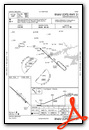
Instrument Approach Procedure (IAP) Charts
Nearby Airports with Instrument Procedures
| ID | Name | Heading / Distance | ||
|---|---|---|---|---|
 |
2A2 | Holley Mountain Airpark Airport | 036° | 3.9 |
|
4A5 | Searcy County Airport | 331° | 20.6 |
|
KHBZ | Heber Springs Municipal Airport | 103° | 22.1 |
|
7M2 | Mountain View Wilcox Memorial Field Airport | 047° | 23.8 |
|
KBDQ | Morrilton Municipal Airport | 205° | 30.5 |
|
KCXW | Conway Regional Airport | 188° | 35.0 |
|
KMPJ | Petit Jean Park Airport | 219° | 35.5 |
|
KRUE | Russellville Regional Airport | 237° | 37.4 |
|
KBVX | Batesville Regional Airport | 078° | 40.1 |
|
42A | Melbourne Municipal - John E Miller Field Airport | 046° | 41.5 |
|
KSRC | Searcy Regional Airport | 123° | 42.0 |
|
KFLP | Marion County Regional Airport | 350° | 42.1 |
Airport Images
Do you have a recent image of this airport? Upload it here!


