Login
Register


CDN
Woodward Field Airport
Official FAA Data Effective 2024-04-18 0901Z
Chart Supplement

VFR Chart of KCDN
Sectional Charts at SkyVector.com
IFR Chart of KCDN
Enroute Charts at SkyVector.com
Location Information for KCDN
Coordinates: N34°17.01' / W80°33.89'Located 03 miles NE of Camden, South Carolina on 396 acres of land. View all Airports in South Carolina.
Surveyed Elevation is 302 feet MSL.
Operations Data
|
|
Airport Communications
| AWOS-3: | 119.975 Tel. 803-424-1979 |
|---|---|
| SHAW APPROACH: | 125.4 318.1 |
| SHAW DEPARTURE: | 125.4 318.1 |
| UNICOM: | 123.000 |
| CTAF: | 123.000 |
| ATIS at SSC (19.2 S): | 132.125 |
| AWOS-3 at SMS (20.1 SE): | 118.075 803-469-6750 |
| AWOS-3 at HVS (23.2 E): | 118.225 843-339-9625 |
- APCH/DEP SVC PRVDD BY JACKSONVILLE ARTCC ON FREQS 124.7/269.55 (COLUMBIA RCAG) WHEN SHAW APCH CTL CLSD.
Nearby Navigation Aids
|
| ||||||||||||||||||||||||||||||||||||||||||||||||||||||||||||


Runway 06/24
| Dimensions: | 5000 x 100 feet / 1524 x 30 meters | |
|---|---|---|
| Surface: | Asphalt in Excellent Condition | |
| Weight Limits: | 19 /F/C/X/T, S-51, D-70, ST-131 | |
| Edge Lighting: | Medium Intensity | |
| Runway 06 | Runway 24 | |
| Coordinates: | N34°16.75' / W80°34.28' | N34°17.26' / W80°33.50' |
| Elevation: | 286.4 | 296.4 |
| Traffic Pattern: | Left | Left |
| Runway Heading: | 52° True | 232° True |
| Markings: | Non-Precision Instrument in good condition. | Non-Precision Instrument in good condition. |
| Glide Slope Indicator | P2L (3.00° Glide Path Angle) | P2L (3.00° Glide Path Angle) |
| REIL: | Yes | Yes |
| Obstacles: | 27 ft Pole 1024 ft from runway, 153 ft left of center | |
Runway 14/32
| Dimensions: | 2998 x 100 feet / 914 x 30 meters | |
|---|---|---|
| Surface: | Asphalt in Fair Condition | |
| Weight Limits: | S-30, D-55, ST-90 | |
| Runway 14 | Runway 32 | |
| Coordinates: | N34°17.20' / W80°34.10' | N34°16.86' / W80°33.68' |
| Elevation: | 298.1 | 299.7 |
| Traffic Pattern: | Left | Left |
| Runway Heading: | 135° True | 315° True |
| Markings: | Basic in good condition. | Basic in good condition. |
| Obstacles: | 43 ft Tree 581 ft from runway, 139 ft right of center | 78 ft Tree 1624 ft from runway, 184 ft right of center |
Services Available
| Fuel: | 100LL (blue), Jet-A |
|---|---|
| Transient Storage: | Hangars,Tiedowns |
| Airframe Repair: | MAJOR |
| Engine Repair: | MAJOR |
| Bottled Oxygen: | LOW |
| Bulk Oxygen: | NONE |
| Other Services: | PILOT INSTRUCTION,AIRCRAFT RENTAL |
Ownership Information
| Ownership: | Publicly owned | |
|---|---|---|
| Owner: | KERSHAW COUNTY | |
| COURTHOUSE, ROOM 202 | ||
| CAMDEN, SC 29020 | ||
| 803-425-1500 | ||
| Manager: | MR. GERALD BLANCHARD | |
| 2203 AIRLINE DRIVE | ||
| CAMDEN, SC 29020 | ||
| 803-729-0925 | ||
Operational Statistics
| Single Engine Aircraft Based on Field: | 20 | Statistics collected for 12 month period ending 2023-02-14 | |
|---|---|---|---|
| Multi-Engine Aircraft Based on Field: | none | Annual Commercial Operations: | none |
| Jet Aircraft Based on Field: | 2 | Annual Commuter Operations: | none |
| Helicopters Based on Field: | none | Annual Air Taxi Operations: | 310 |
| Military Aircraft Based on Field: | none | Annual Military Operations: | 250 |
| Gliders Based on Field: | none | Annual GA Local Operations: | 5161 |
| Ultralights Based on Field: | none | Annual GA Itinerant Operations: | 2529 |
Other Remarks
- FOR CD CTC JACKSONVILLE ARTCC AT 904-845-1592.
- DUSK-DAWN. MIRL RWY 06/24 PRESET LOW INTST; TO INCR INTST AND ACTVT REIL RWY 06 & 24, PAPI RWY 06 & 24 - CTAF.
Weather Minimums

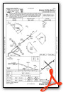
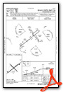
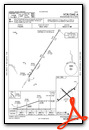
Instrument Approach Procedure (IAP) Charts
Nearby Airports with Instrument Procedures
| ID | Name | Heading / Distance | ||
|---|---|---|---|---|
 |
KSSC | Shaw AFB Airport | 165° | 19.2 |
|
KSMS | Sumter Airport | 149° | 20.0 |
|
KHVS | Hartsville Regional Airport | 071° | 23.3 |
|
KMMT | Mc Entire Jngb Airport | 208° | 24.7 |
|
KFDW | Fairfield County Airport | 274° | 27.1 |
|
KCUB | Jim Hamilton L B Owens Airport | 228° | 28.5 |
|
KPYG | Pageland Airport | 021° | 29.5 |
|
KLKR | Lancaster County-Mc Whirter Field Airport | 331° | 30.0 |
|
KCAE | Columbia Metro Airport | 233° | 34.5 |
|
KUDG | Darlington County Airport | 073° | 35.1 |
|
N52 | Jaars-Townsend Airport | 345° | 35.9 |
|
KCQW | Cheraw Municipal/Lynch Bellinger Field Airport | 049° | 39.6 |
Airport Images
Do you have a recent image of this airport? Upload it here!


